Sitdown Mountain Topo Map Washington
To zoom in, hover over the map of Sitdown Mountain
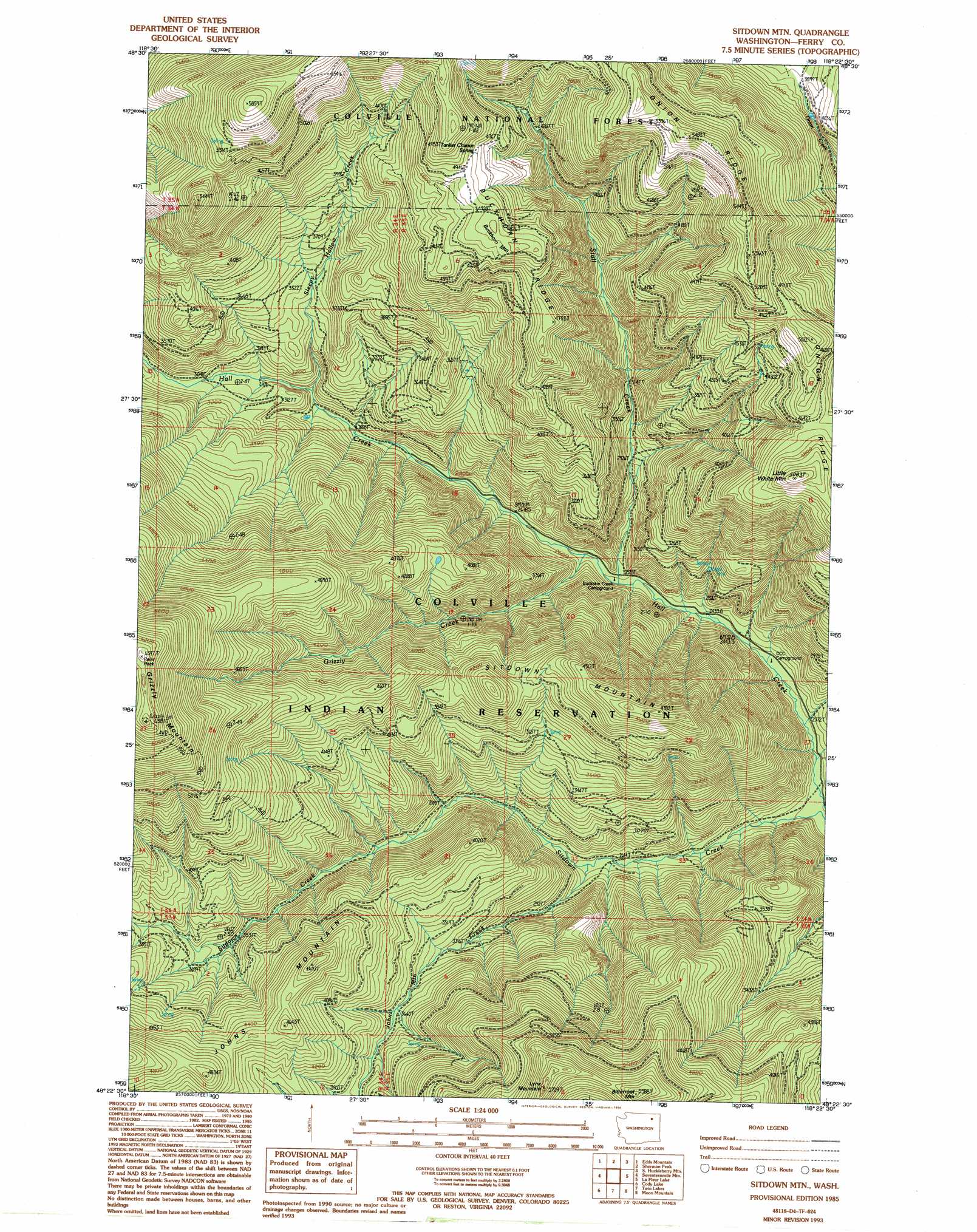
USGS Topo Quad 48118d4 - 1:24,000 scale
| Topo Map Name: | Sitdown Mountain |
| USGS Topo Quad ID: | 48118d4 |
| Print Size: | ca. 21 1/4" wide x 27" high |
| Southeast Coordinates: | 48.375° N latitude / 118.375° W longitude |
| Map Center Coordinates: | 48.4375° N latitude / 118.4375° W longitude |
| U.S. State: | WA |
| Filename: | o48118d4.jpg |
| Download Map JPG Image: | Sitdown Mountain topo map 1:24,000 scale |
| Map Type: | Topographic |
| Topo Series: | 7.5´ |
| Map Scale: | 1:24,000 |
| Source of Map Images: | United States Geological Survey (USGS) |
| Alternate Map Versions: |
Sitdown Mtn WA 1985, updated 1985 Download PDF Buy paper map Sitdown Mtn. WA 1985, updated 1994 Download PDF Buy paper map Sitdown Mtn. WA 1992, updated 1996 Download PDF Buy paper map Sitdown Mountain WA 2011 Download PDF Buy paper map Sitdown Mountain WA 2014 Download PDF Buy paper map |
| FStopo: | US Forest Service topo Sitdown Mountain is available: Download FStopo PDF Download FStopo TIF |
1:24,000 Topo Quads surrounding Sitdown Mountain
Republic |
Cooke Mountain |
Copper Butte |
Jackknife Mountain |
Boyds |
Bear Mountain |
Edds Mountain |
Sherman Peak |
South Huckleberry Mountain |
Bangs Mountain |
Thirteenmile Creek |
Seventeenmile Mountain |
Sitdown Mountain |
La Fleur Lake |
Rice |
Cody Butte |
Cody Lake |
Twin Lakes |
Moon Mountain |
Inchelium |
Louie Creek |
Frosty Meadows |
Gold Mountain |
Kewa |
Cedonia |
> Back to 48118a1 at 1:100,000 scale
> Back to 48118a1 at 1:250,000 scale
> Back to U.S. Topo Maps home
Sitdown Mountain topo map: Gazetteer
Sitdown Mountain: Springs
Tanker Chance Spring elevation 1496m 4908′Sitdown Mountain: Streams
Grizzly Creek elevation 780m 2559′Johns Mountain Creek elevation 816m 2677′
Sitdown Creek elevation 698m 2290′
Sleepy Hollow Creek elevation 889m 2916′
Stall Creek elevation 767m 2516′
Sitdown Mountain: Summits
Bitterfoot Mountain elevation 1696m 5564′Grizzly Mountain elevation 1944m 6377′
Johns Mountain elevation 1459m 4786′
Little White Mountain elevation 1540m 5052′
Lynx Mountain elevation 1711m 5613′
Sitdown Mountain elevation 1441m 4727′
Sitdown Mountain: Trails
White Mountain Trail (historical) elevation 1680m 5511′Sitdown Mountain digital topo map on disk
Buy this Sitdown Mountain topo map showing relief, roads, GPS coordinates and other geographical features, as a high-resolution digital map file on DVD: