Strawberry Mountain Topo Map Washington
To zoom in, hover over the map of Strawberry Mountain
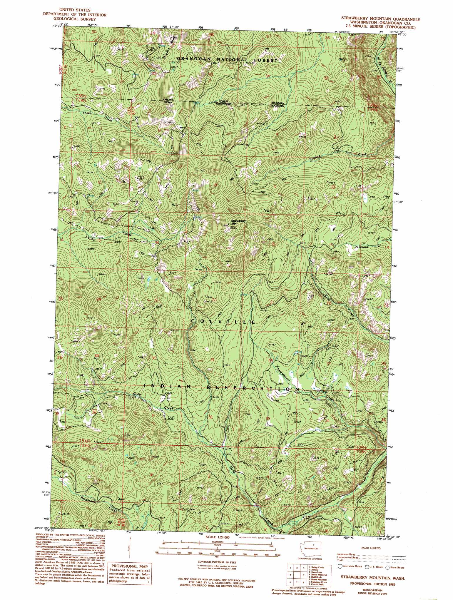
USGS Topo Quad 48118d8 - 1:24,000 scale
| Topo Map Name: | Strawberry Mountain |
| USGS Topo Quad ID: | 48118d8 |
| Print Size: | ca. 21 1/4" wide x 27" high |
| Southeast Coordinates: | 48.375° N latitude / 118.875° W longitude |
| Map Center Coordinates: | 48.4375° N latitude / 118.9375° W longitude |
| U.S. State: | WA |
| Filename: | o48118d8.jpg |
| Download Map JPG Image: | Strawberry Mountain topo map 1:24,000 scale |
| Map Type: | Topographic |
| Topo Series: | 7.5´ |
| Map Scale: | 1:24,000 |
| Source of Map Images: | United States Geological Survey (USGS) |
| Alternate Map Versions: |
Strawberry Mountain WA 1989, updated 1989 Download PDF Buy paper map Strawberry Mountain WA 1989, updated 1994 Download PDF Buy paper map Strawberry Mountain WA 2001, updated 2004 Download PDF Buy paper map Strawberry Mountain WA 2011 Download PDF Buy paper map Strawberry Mountain WA 2014 Download PDF Buy paper map |
| FStopo: | US Forest Service topo Strawberry Mountain is available: Download FStopo PDF Download FStopo TIF |
1:24,000 Topo Quads surrounding Strawberry Mountain
Cayuse Mountain |
Mount Annie |
Wauconda Summit |
Storm King Mountain |
Republic |
Tunk Mountain |
Bailey Creek |
Aeneas |
Swan Lake |
Bear Mountain |
Crawfish Lake |
Moses Meadows |
Strawberry Mountain |
Bald Knob |
Thirteenmile Creek |
Disautel |
Moses Mountain |
Stepstone Creek |
Central Peak |
Cody Butte |
Hopkins Canyon |
Armstrong Creek |
Nespelem |
Nespelem Ne |
Louie Creek |
> Back to 48118a1 at 1:100,000 scale
> Back to 48118a1 at 1:250,000 scale
> Back to U.S. Topo Maps home
Strawberry Mountain topo map: Gazetteer
Strawberry Mountain: Springs
Sixmile Spring (historical) elevation 1325m 4347′Strawberry Mountain: Streams
Strawberry Creek elevation 814m 2670′Strawberry Mountain: Summits
Dugout Mountain elevation 1623m 5324′Strawberry Mountain elevation 1781m 5843′
Strawberry Mountain: Trails
Dugout Lookout Trail (historical) elevation 1348m 4422′Strawberry Mountain digital topo map on disk
Buy this Strawberry Mountain topo map showing relief, roads, GPS coordinates and other geographical features, as a high-resolution digital map file on DVD: