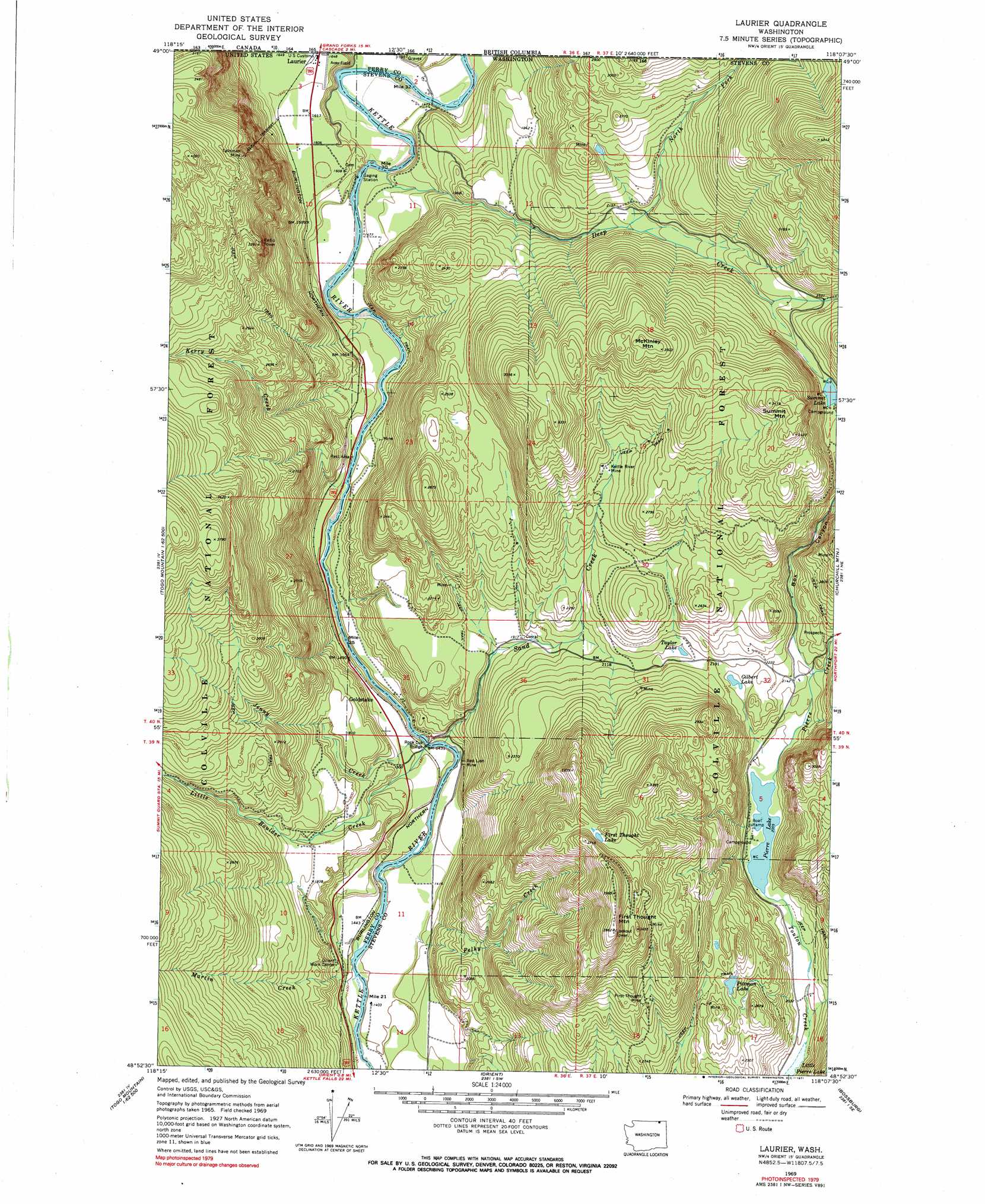
Laurier Topo Map Washington
To zoom in, hover over the map of Laurier
USGS Topo Quad 48118h2 - 1:24,000 scale
| Topo Map Name: | Laurier |
| USGS Topo Quad ID: | 48118h2 |
| Print Size: | ca. 21 1/4" wide x 27" high |
| Southeast Coordinates: | 48.875° N latitude / 118.125° W longitude |
| Map Center Coordinates: | 48.9375° N latitude / 118.1875° W longitude |
| U.S. State: | WA |
| Filename: | o48118h2.jpg |
| Download Map JPG Image: | Laurier topo map 1:24,000 scale |
| Map Type: | Topographic |
| Topo Series: | 7.5´ |
| Map Scale: | 1:24,000 |
| Source of Map Images: | United States Geological Survey (USGS) |
| Alternate Map Versions: |
Laurier WA 1969, updated 1971 Download PDF Buy paper map Laurier WA 1969, updated 1971 Download PDF Buy paper map Laurier WA 1992, updated 1996 Download PDF Buy paper map Laurier WA 2011 Download PDF Buy paper map Laurier WA 2014 Download PDF Buy paper map |
| FStopo: | US Forest Service topo Laurier is available: Download FStopo PDF Download FStopo TIF |
1:24,000 Topo Quads surrounding Laurier
Boundary Mountain |
Independent Mountain |
Laurier |
Churchill Mountain |
Belshazzar Mountain |
Mount Leona |
Bulldog Mountain |
Orient |
Bossburg |
China Bend |
Copper Butte |
Jackknife Mountain |
Boyds |
Marcus |
Echo Valley |
> Back to 48118e1 at 1:100,000 scale
> Back to 48118a1 at 1:250,000 scale
> Back to U.S. Topo Maps home
Laurier topo map: Gazetteer
Laurier: Airports
Avey Field State Airport elevation 505m 1656′Standing Circle R Ranch Airport elevation 431m 1414′
Laurier: Bridges
Rock Cut Bridge elevation 433m 1420′Laurier: Lakes
First Thought Lake elevation 1058m 3471′Gilbert Lake elevation 657m 2155′
Little Pierre Lake elevation 609m 1998′
Pierre Lake elevation 612m 2007′
Pittman Lake elevation 762m 2500′
Summit Lake elevation 773m 2536′
Taylor Lake elevation 658m 2158′
Laurier: Mines
First Thought Mine elevation 879m 2883′Kettle River Mine elevation 755m 2477′
Red Lion Mine elevation 449m 1473′
Talisman Mine elevation 1042m 3418′
Laurier: Populated Places
Goldstake elevation 460m 1509′Laurier elevation 504m 1653′
Laurier: Streams
Deep Creek elevation 453m 1486′Jenny Creek elevation 428m 1404′
Kerry Creek elevation 487m 1597′
Little Boulder Creek elevation 435m 1427′
Martin Creek elevation 425m 1394′
North Fork Deep Creek elevation 650m 2132′
Pelky Creek elevation 434m 1423′
Pierre Creek elevation 612m 2007′
Sand Creek elevation 427m 1400′
Laurier: Summits
First Thought Mountain elevation 1207m 3959′McKinley Mountain elevation 1060m 3477′
Summit Mountain elevation 1053m 3454′
Laurier: Valleys
Box Canyon elevation 646m 2119′Laurier digital topo map on disk
Buy this Laurier topo map showing relief, roads, GPS coordinates and other geographical features, as a high-resolution digital map file on DVD: