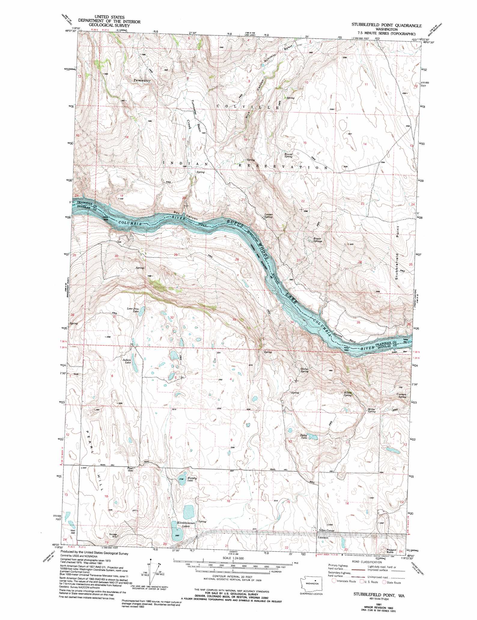
Stubblefield Point Topo Map Washington
To zoom in, hover over the map of Stubblefield Point
USGS Topo Quad 48119a4 - 1:24,000 scale
| Topo Map Name: | Stubblefield Point |
| USGS Topo Quad ID: | 48119a4 |
| Print Size: | ca. 21 1/4" wide x 27" high |
| Southeast Coordinates: | 48° N latitude / 119.375° W longitude |
| Map Center Coordinates: | 48.0625° N latitude / 119.4375° W longitude |
| U.S. State: | WA |
| Filename: | o48119a4.jpg |
| Download Map JPG Image: | Stubblefield Point topo map 1:24,000 scale |
| Map Type: | Topographic |
| Topo Series: | 7.5´ |
| Map Scale: | 1:24,000 |
| Source of Map Images: | United States Geological Survey (USGS) |
| Alternate Map Versions: |
Stubblefield Point WA 1981, updated 1981 Download PDF Buy paper map Stubblefield Point WA 1981, updated 1994 Download PDF Buy paper map Stubblefield Point WA 2011 Download PDF Buy paper map Stubblefield Point WA 2014 Download PDF Buy paper map |
1:24,000 Topo Quads surrounding Stubblefield Point
Malott |
Okanogan |
Omak Lake |
Camp Seven |
Disautel |
Monse |
White Lakes |
Joe Lake |
Boot Mountain |
Hopkins Canyon |
Bridgeport |
Bridgeport Point |
Stubblefield Point |
Trefry Canyon |
Alameda Flat |
Chief Joseph Dam |
Coleman Hill |
Leahy |
Foster Coulee |
Barker Canyon |
Mansfield |
Piersol Hills |
Barnes Butte |
Sims Corner |
Steamboat Rock West |
> Back to 48119a1 at 1:100,000 scale
> Back to 48118a1 at 1:250,000 scale
> Back to U.S. Topo Maps home
Stubblefield Point topo map: Gazetteer
Stubblefield Point: Basins
Achimin Basin elevation 594m 1948′Tumwater Basin elevation 446m 1463′
Stubblefield Point: Bends
Gaviota Bend elevation 289m 948′Stubblefield Point: Cliffs
Stubblefield Point elevation 688m 2257′Stubblefield Point: Lakes
Duley Lake elevation 683m 2240′Judson Lake elevation 686m 2250′
Klinkhammer Lakes elevation 640m 2099′
Lone Pine Lake elevation 660m 2165′
Murphy Lake elevation 655m 2148′
Stubblefield Point: Populated Places
Nilles Corner elevation 689m 2260′Stubblefield Point: Rapids
Eagle Rapids elevation 290m 951′Long Rapids elevation 290m 951′
White Cap Rapids elevation 290m 951′
Stubblefield Point: Springs
Bryan Springs elevation 503m 1650′Connors Spring elevation 511m 1676′
Gladys Spring elevation 555m 1820′
Lenner Spring elevation 408m 1338′
Miller Spring elevation 659m 2162′
Rilette Spring elevation 656m 2152′
Round Spring elevation 652m 2139′
Vaughn Spring elevation 621m 2037′
Stubblefield Point: Streams
Tumwater Creek elevation 290m 951′Stubblefield Point: Valleys
Box Canyon elevation 301m 987′Rice Canyon elevation 437m 1433′
Stubblefield Point digital topo map on disk
Buy this Stubblefield Point topo map showing relief, roads, GPS coordinates and other geographical features, as a high-resolution digital map file on DVD: