Bridgeport Topo Map Washington
To zoom in, hover over the map of Bridgeport
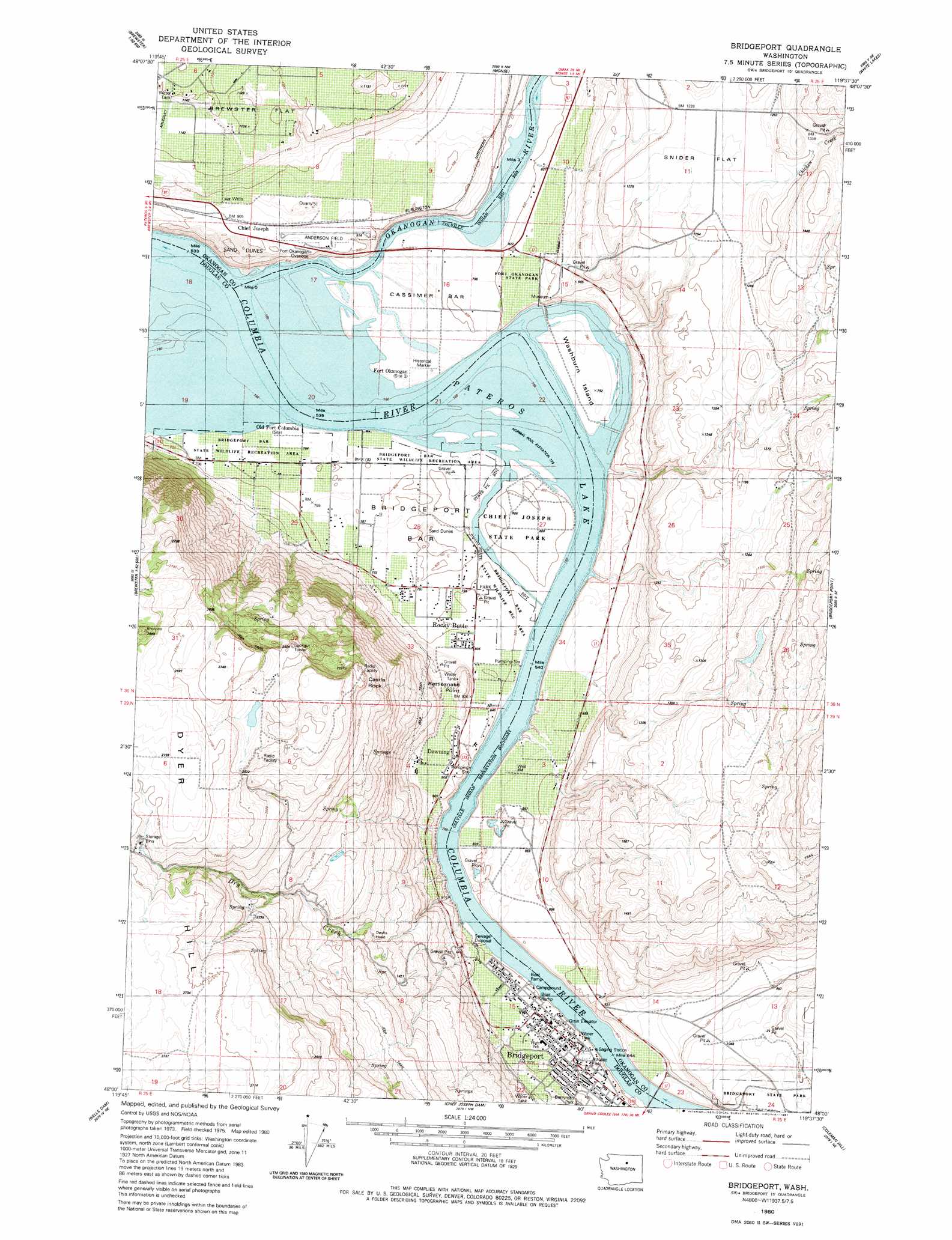
USGS Topo Quad 48119a6 - 1:24,000 scale
| Topo Map Name: | Bridgeport |
| USGS Topo Quad ID: | 48119a6 |
| Print Size: | ca. 21 1/4" wide x 27" high |
| Southeast Coordinates: | 48° N latitude / 119.625° W longitude |
| Map Center Coordinates: | 48.0625° N latitude / 119.6875° W longitude |
| U.S. State: | WA |
| Filename: | o48119a6.jpg |
| Download Map JPG Image: | Bridgeport topo map 1:24,000 scale |
| Map Type: | Topographic |
| Topo Series: | 7.5´ |
| Map Scale: | 1:24,000 |
| Source of Map Images: | United States Geological Survey (USGS) |
| Alternate Map Versions: |
Bridgeport WA 1980, updated 1981 Download PDF Buy paper map Bridgeport WA 2011 Download PDF Buy paper map Bridgeport WA 2014 Download PDF Buy paper map |
1:24,000 Topo Quads surrounding Bridgeport
Thrapp Mountain |
Chiliwist Valley |
Malott |
Okanogan |
Omak Lake |
Knowton Knob |
Rat Lake |
Monse |
White Lakes |
Joe Lake |
Pateros |
Brewster |
Bridgeport |
Bridgeport Point |
Stubblefield Point |
Azwell |
Wells Dam |
Chief Joseph Dam |
Coleman Hill |
Leahy |
Chelan Falls |
Mud Spring |
Mansfield |
Piersol Hills |
Barnes Butte |
> Back to 48119a1 at 1:100,000 scale
> Back to 48118a1 at 1:250,000 scale
> Back to U.S. Topo Maps home
Bridgeport topo map: Gazetteer
Bridgeport: Airports
Anderson Field elevation 279m 915′Bridgeport: Bars
Buenna Bar elevation 239m 784′Cassimer Bar elevation 242m 793′
Bridgeport: Cliffs
Devils Head elevation 467m 1532′Bridgeport: Flats
Snider Flat elevation 372m 1220′Bridgeport: Islands
Washburn Island elevation 242m 793′Bridgeport: Parks
Bridgeport Bar State Wildlife Recreation Area elevation 241m 790′Bridgeport Park elevation 251m 823′
Chief Joseph State Park elevation 245m 803′
Fort Okanogan State Park elevation 285m 935′
Rock Ridge Park elevation 246m 807′
Waterfront Park elevation 239m 784′
Bridgeport: Populated Places
Bridgeport elevation 259m 849′Downing elevation 274m 898′
Rocky Butte elevation 249m 816′
Bridgeport: Rapids
Reef Rapids elevation 239m 784′Bridgeport: Streams
Chicken Creek elevation 373m 1223′Dry Creek elevation 253m 830′
Okanogan River elevation 239m 784′
Bridgeport: Summits
Castle Rock elevation 771m 2529′Rattlesnake Point elevation 320m 1049′
Timber Peak elevation 900m 2952′
Bridgeport digital topo map on disk
Buy this Bridgeport topo map showing relief, roads, GPS coordinates and other geographical features, as a high-resolution digital map file on DVD: