Cayuse Mountain Topo Map Washington
To zoom in, hover over the map of Cayuse Mountain
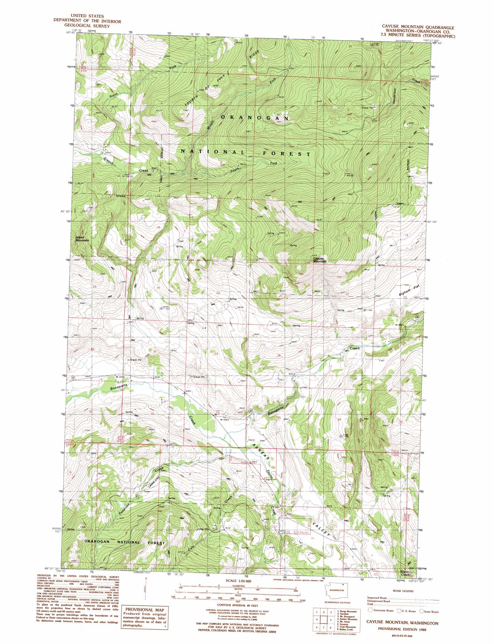
USGS Topo Quad 48119f2 - 1:24,000 scale
| Topo Map Name: | Cayuse Mountain |
| USGS Topo Quad ID: | 48119f2 |
| Print Size: | ca. 21 1/4" wide x 27" high |
| Southeast Coordinates: | 48.625° N latitude / 119.125° W longitude |
| Map Center Coordinates: | 48.6875° N latitude / 119.1875° W longitude |
| U.S. State: | WA |
| Filename: | o48119f2.jpg |
| Download Map JPG Image: | Cayuse Mountain topo map 1:24,000 scale |
| Map Type: | Topographic |
| Topo Series: | 7.5´ |
| Map Scale: | 1:24,000 |
| Source of Map Images: | United States Geological Survey (USGS) |
| Alternate Map Versions: |
Cayuse Mountain WA 1988, updated 1988 Download PDF Buy paper map Cayuse Mountain WA 2001, updated 2004 Download PDF Buy paper map Cayuse Mountain WA 2011 Download PDF Buy paper map Cayuse Mountain WA 2014 Download PDF Buy paper map |
| FStopo: | US Forest Service topo Cayuse Mountain is available: Download FStopo PDF Download FStopo TIF |
1:24,000 Topo Quads surrounding Cayuse Mountain
Oroville |
Mount Hull |
Molson |
Chesaw |
Buckhorn Mountain |
Ellisforde |
Burge Mountain |
Havillah |
Mount Bonaparte |
Bodie |
Tonasket |
Barker Mountain |
Cayuse Mountain |
Mount Annie |
Wauconda Summit |
Keystone |
Synarep |
Tunk Mountain |
Bailey Creek |
Aeneas |
The Pothole |
Omak Mountain |
Crawfish Lake |
Moses Meadows |
Strawberry Mountain |
> Back to 48119e1 at 1:100,000 scale
> Back to 48118a1 at 1:250,000 scale
> Back to U.S. Topo Maps home
Cayuse Mountain topo map: Gazetteer
Cayuse Mountain: Flats
Bigham Flat elevation 1033m 3389′Cayuse Mountain: Ridges
Fourth of July Ridge elevation 1389m 4557′Cayuse Mountain: Streams
Cole Creek elevation 720m 2362′Middle Fork Siwash Creek elevation 1027m 3369′
North Fork Siwash Creek elevation 899m 2949′
Patterson Creek elevation 711m 2332′
Peony Creek elevation 712m 2335′
South Fork Siwash Creek elevation 1030m 3379′
Cayuse Mountain: Summits
Cayuse Mountain elevation 1568m 5144′Cayuse Mountain: Trails
North Fork Trail elevation 1270m 4166′Cayuse Mountain: Valleys
Aeneas Valley elevation 712m 2335′Cayuse Mountain digital topo map on disk
Buy this Cayuse Mountain topo map showing relief, roads, GPS coordinates and other geographical features, as a high-resolution digital map file on DVD: