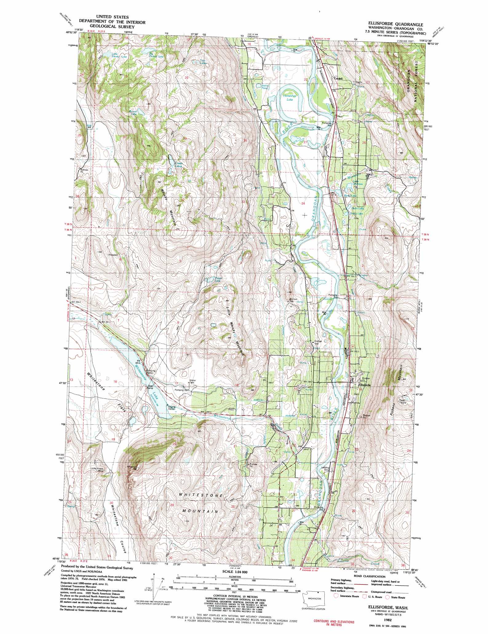
Ellisforde Topo Map Washington
To zoom in, hover over the map of Ellisforde
USGS Topo Quad 48119g4 - 1:24,000 scale
| Topo Map Name: | Ellisforde |
| USGS Topo Quad ID: | 48119g4 |
| Print Size: | ca. 21 1/4" wide x 27" high |
| Southeast Coordinates: | 48.75° N latitude / 119.375° W longitude |
| Map Center Coordinates: | 48.8125° N latitude / 119.4375° W longitude |
| U.S. State: | WA |
| Filename: | o48119g4.jpg |
| Download Map JPG Image: | Ellisforde topo map 1:24,000 scale |
| Map Type: | Topographic |
| Topo Series: | 7.5´ |
| Map Scale: | 1:24,000 |
| Source of Map Images: | United States Geological Survey (USGS) |
| Alternate Map Versions: |
Ellisforde WA 1982, updated 1982 Download PDF Buy paper map Ellisforde WA 2001, updated 2004 Download PDF Buy paper map Ellisforde WA 2011 Download PDF Buy paper map Ellisforde WA 2014 Download PDF Buy paper map |
| FStopo: | US Forest Service topo Ellisforde is available: Download FStopo PDF Download FStopo TIF |
1:24,000 Topo Quads surrounding Ellisforde
Nighthawk |
Bullfrog Mountain |
Oroville |
Mount Hull |
Molson |
Loomis |
Enterprise |
Ellisforde |
Burge Mountain |
Havillah |
Blue Goat Mountain |
Aeneas Lake |
Tonasket |
Barker Mountain |
Cayuse Mountain |
Conconully East |
Riverside |
Keystone |
Synarep |
Tunk Mountain |
> Back to 48119e1 at 1:100,000 scale
> Back to 48118a1 at 1:250,000 scale
> Back to U.S. Topo Maps home
Ellisforde topo map: Gazetteer
Ellisforde: Dams
Whitestone Lake Dam elevation 386m 1266′Ellisforde: Flats
Whitestone Flats elevation 437m 1433′Ellisforde: Lakes
Big Finney Lake elevation 760m 2493′Borst Lake elevation 290m 951′
Crater Lakes elevation 751m 2463′
Finley Lake elevation 287m 941′
Horseshoe Lake elevation 276m 905′
Irwins Pond elevation 811m 2660′
Lake Andrews elevation 299m 980′
Little Finney Lake elevation 761m 2496′
Poison Lake elevation 511m 1676′
Stern Lake elevation 290m 951′
Twin Lakes elevation 601m 1971′
Ellisforde: Mines
Lucky Knock Mine elevation 436m 1430′Ellisforde: Populated Places
Cordell elevation 277m 908′Ellisforde elevation 277m 908′
Ellisforde: Reservoirs
Whitestone Lake elevation 386m 1266′Ellisforde: Streams
Antoine Creek elevation 277m 908′Mosquito Creek elevation 273m 895′
Whitestone Creek elevation 271m 889′
Ellisforde: Summits
Little Whisky Mountain elevation 624m 2047′Pickens Mountain elevation 846m 2775′
Whisky Mountain elevation 869m 2851′
Whitestone Mountain elevation 861m 2824′
Ellisforde digital topo map on disk
Buy this Ellisforde topo map showing relief, roads, GPS coordinates and other geographical features, as a high-resolution digital map file on DVD: