Hurley Peak Topo Map Washington
To zoom in, hover over the map of Hurley Peak
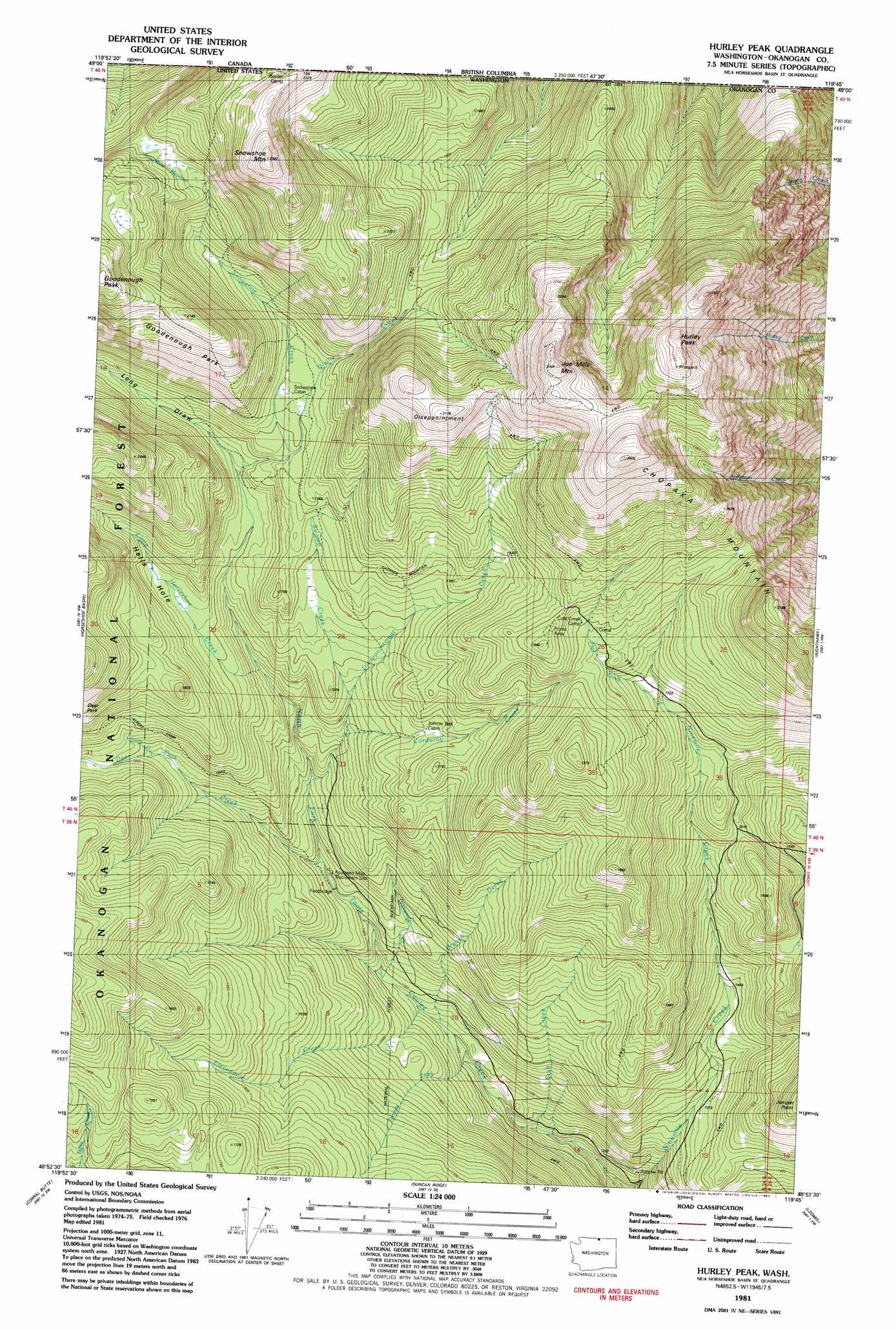
USGS Topo Quad 48119h7 - 1:24,000 scale
| Topo Map Name: | Hurley Peak |
| USGS Topo Quad ID: | 48119h7 |
| Print Size: | ca. 21 1/4" wide x 27" high |
| Southeast Coordinates: | 48.875° N latitude / 119.75° W longitude |
| Map Center Coordinates: | 48.9375° N latitude / 119.8125° W longitude |
| U.S. State: | WA |
| Filename: | o48119h7.jpg |
| Download Map JPG Image: | Hurley Peak topo map 1:24,000 scale |
| Map Type: | Topographic |
| Topo Series: | 7.5´ |
| Map Scale: | 1:24,000 |
| Source of Map Images: | United States Geological Survey (USGS) |
| Alternate Map Versions: |
Hurley Peak WA 1981, updated 1982 Download PDF Buy paper map Hurley Peak WA 2001, updated 2004 Download PDF Buy paper map Hurley Peak WA 2011 Download PDF Buy paper map Hurley Peak WA 2014 Download PDF Buy paper map |
| FStopo: | US Forest Service topo Hurley Peak is available: Download FStopo PDF Download FStopo TIF |
1:24,000 Topo Quads surrounding Hurley Peak
Bauerman Ridge |
Horseshoe Basin |
Hurley Peak |
Nighthawk |
Bullfrog Mountain |
Coleman Peak |
Corral Butte |
Duncan Ridge |
Loomis |
Enterprise |
Spur Peak |
Tiffany Mountain |
Coxit Mountain |
Blue Goat Mountain |
Aeneas Lake |
> Back to 48119e1 at 1:100,000 scale
> Back to 48118a1 at 1:250,000 scale
> Back to U.S. Topo Maps home
Hurley Peak topo map: Gazetteer
Hurley Peak: Basins
Hells Hole elevation 1681m 5515′Hurley Peak: Capes
Juniper Point elevation 1553m 5095′Hurley Peak: Flats
Snowshoe Meadow elevation 1990m 6528′Hurley Peak: Parks
Fourteen Mile Recreation Site elevation 1431m 4694′Goodenough Park elevation 1992m 6535′
Hurley Peak: Streams
Branch Creek elevation 1312m 4304′Cold Creek elevation 1718m 5636′
Corduroy Creek elevation 1570m 5150′
Deer Park Creek elevation 1434m 4704′
Disappointment Creek elevation 1490m 4888′
Elevenmile Creek elevation 1327m 4353′
Little Horseshoe Creek elevation 1628m 5341′
Olallie Creek elevation 1729m 5672′
Snehumption Creek elevation 1547m 5075′
Snowshoe Creek elevation 1729m 5672′
Stub Creek elevation 1222m 4009′
Sunday Creek elevation 1592m 5223′
Swamp Creek elevation 1622m 5321′
Tenmile Creek elevation 1296m 4251′
Twelvemile Creek elevation 1360m 4461′
Hurley Peak: Summits
Chopaka Mountain elevation 2403m 7883′Disappointment elevation 2175m 7135′
Hurley Peak elevation 2379m 7805′
Joe Mills Mountain elevation 2334m 7657′
Snowshoe Mountain elevation 2344m 7690′
Hurley Peak: Trails
Chopaka Mountain Trail elevation 1758m 5767′North Fork Toats Creek Trail elevation 1422m 4665′
Hurley Peak: Valleys
Long Draw elevation 1693m 5554′Hurley Peak digital topo map on disk
Buy this Hurley Peak topo map showing relief, roads, GPS coordinates and other geographical features, as a high-resolution digital map file on DVD: