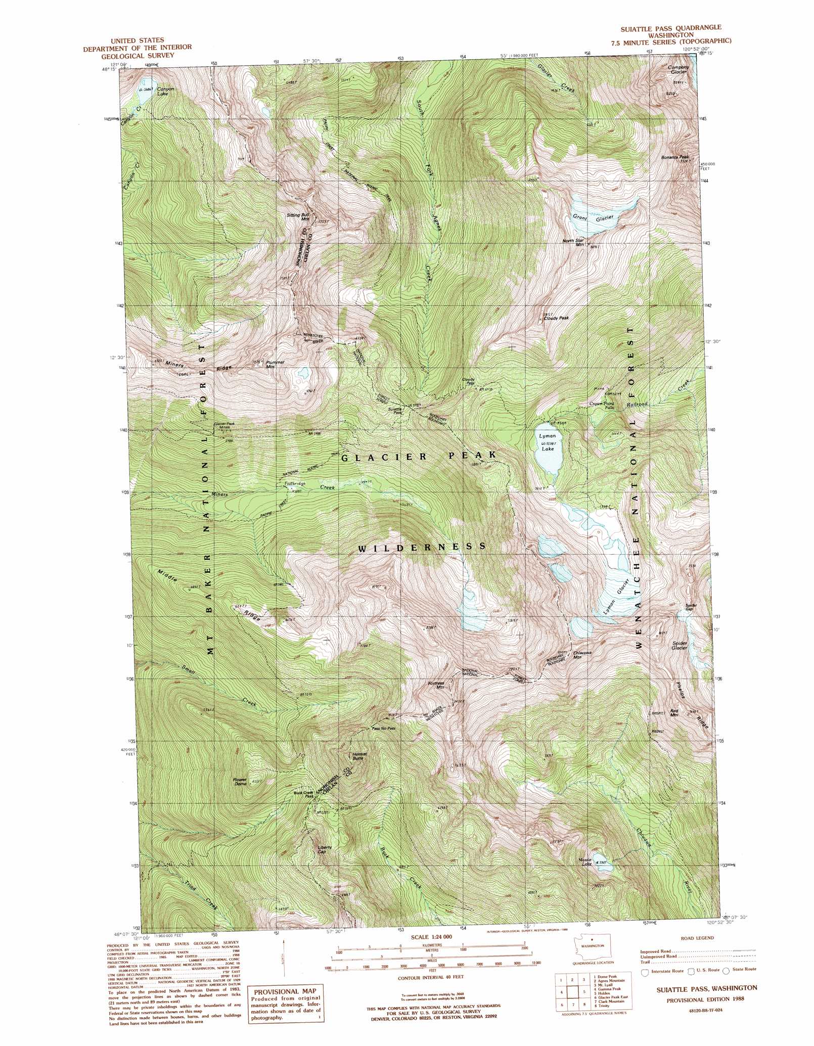
Suiattle Pass Topo Map Washington
To zoom in, hover over the map of Suiattle Pass
USGS Topo Quad 48120b8 - 1:24,000 scale
| Topo Map Name: | Suiattle Pass |
| USGS Topo Quad ID: | 48120b8 |
| Print Size: | ca. 21 1/4" wide x 27" high |
| Southeast Coordinates: | 48.125° N latitude / 120.875° W longitude |
| Map Center Coordinates: | 48.1875° N latitude / 120.9375° W longitude |
| U.S. State: | WA |
| Filename: | o48120b8.jpg |
| Download Map JPG Image: | Suiattle Pass topo map 1:24,000 scale |
| Map Type: | Topographic |
| Topo Series: | 7.5´ |
| Map Scale: | 1:24,000 |
| Source of Map Images: | United States Geological Survey (USGS) |
| Alternate Map Versions: |
Suiattle Pass WA 1988, updated 1988 Download PDF Buy paper map Suiattle Pass WA 1988, updated 1988 Download PDF Buy paper map Suiattle Pass WA 1999, updated 2002 Download PDF Buy paper map Suiattle Pass WA 2011 Download PDF Buy paper map Suiattle Pass WA 2014 Download PDF Buy paper map |
| FStopo: | US Forest Service topo Suiattle Pass is available: Download FStopo PDF Download FStopo TIF |
1:24,000 Topo Quads surrounding Suiattle Pass
Sonny Boy Lakes |
Cascade Pass |
Goode Mountain |
Mcgregor Mountain |
Mcalester Mountain |
Downey Mountain |
Dome Peak |
Agnes Mountain |
Mount Lyall |
Stehekin |
Lime Mountain |
Gamma Peak |
Suiattle Pass |
Holden |
Pinnacle Mountain |
Glacier Peak West |
Glacier Peak East |
Clark Mountain |
Trinity |
Saska Peak |
Benchmark Mountain |
Poe Mountain |
Mount David |
Schaefer Lake |
Chikamin Creek |
> Back to 48120a1 at 1:100,000 scale
> Back to 48120a1 at 1:250,000 scale
> Back to U.S. Topo Maps home
Suiattle Pass topo map: Gazetteer
Suiattle Pass: Falls
Crown Point Falls elevation 1565m 5134′Suiattle Pass: Forests
Lake Wenatchee Ranger District (historical) elevation 1378m 4520′Suiattle Pass: Gaps
Buck Creek Pass elevation 1767m 5797′Cloudy Pass elevation 1963m 6440′
Pass No Pass elevation 1942m 6371′
Spider Gap elevation 2156m 7073′
Suiattle Pass elevation 1819m 5967′
Suiattle Pass: Glaciers
Grant Glacier elevation 2218m 7276′Lyman Glacier elevation 1989m 6525′
Spider Glacier elevation 2009m 6591′
Suiattle Pass: Lakes
Canyon Lake elevation 1710m 5610′Lyman Lake elevation 1708m 5603′
Massie Lake elevation 1803m 5915′
Suiattle Pass: Mines
Glacier Peak Mines elevation 1780m 5839′Suiattle Pass: Ridges
Middle Ridge elevation 2025m 6643′Suiattle Pass: Streams
Rubin Creek elevation 1234m 4048′Suiattle Pass: Summits
Chiwawa Mountain elevation 2576m 8451′Cloudy Peak elevation 2367m 7765′
Flower Dome elevation 1924m 6312′
Fortress Mountain elevation 2643m 8671′
Helmet Butte elevation 2218m 7276′
Liberty Cap elevation 2059m 6755′
North Star Mountain elevation 2436m 7992′
Plummer Mountain elevation 2398m 7867′
Red Mountain elevation 2317m 7601′
Sitting Bull Mountain elevation 2360m 7742′
Suiattle Pass: Trails
Miners Creek Trail (historical) elevation 1674m 5492′Suiattle Pass digital topo map on disk
Buy this Suiattle Pass topo map showing relief, roads, GPS coordinates and other geographical features, as a high-resolution digital map file on DVD: