Sun Mountain Topo Map Washington
To zoom in, hover over the map of Sun Mountain
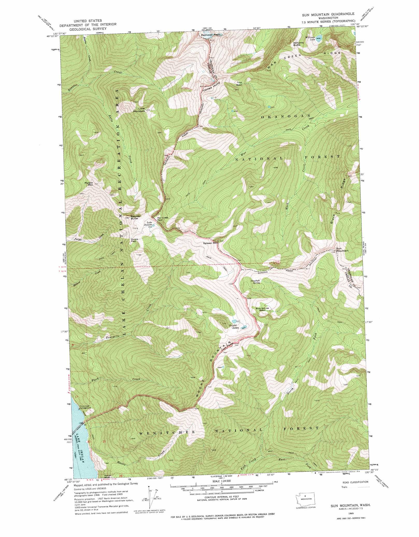
USGS Topo Quad 48120c5 - 1:24,000 scale
| Topo Map Name: | Sun Mountain |
| USGS Topo Quad ID: | 48120c5 |
| Print Size: | ca. 21 1/4" wide x 27" high |
| Southeast Coordinates: | 48.25° N latitude / 120.5° W longitude |
| Map Center Coordinates: | 48.3125° N latitude / 120.5625° W longitude |
| U.S. State: | WA |
| Filename: | o48120c5.jpg |
| Download Map JPG Image: | Sun Mountain topo map 1:24,000 scale |
| Map Type: | Topographic |
| Topo Series: | 7.5´ |
| Map Scale: | 1:24,000 |
| Source of Map Images: | United States Geological Survey (USGS) |
| Alternate Map Versions: |
Sun Mountain WA 1969, updated 1973 Download PDF Buy paper map Sun Mountain WA 1969, updated 1978 Download PDF Buy paper map Sun Mountain WA 2002, updated 2006 Download PDF Buy paper map Sun Mountain WA 2011 Download PDF Buy paper map Sun Mountain WA 2014 Download PDF Buy paper map |
| FStopo: | US Forest Service topo Sun Mountain is available: Download FStopo PDF Download FStopo TIF |
1:24,000 Topo Quads surrounding Sun Mountain
Mount Arriva |
Washington Pass |
Silver Star Mountain |
Mazama |
Rendevous Mountain |
Mcgregor Mountain |
Mcalester Mountain |
Gilbert |
Midnight Mountain |
Thompson Ridge |
Mount Lyall |
Stehekin |
Sun Mountain |
Oval Peak |
Hoodoo Peak |
Holden |
Pinnacle Mountain |
Lucerne |
Prince Creek |
Martin Peak |
Trinity |
Saska Peak |
Pyramid Mountain |
Big Goat Mountain |
South Navarre Peak |
> Back to 48120a1 at 1:100,000 scale
> Back to 48120a1 at 1:250,000 scale
> Back to U.S. Topo Maps home
Sun Mountain topo map: Gazetteer
Sun Mountain: Basins
Blue Grouse Basin elevation 1978m 6489′Tony Basin elevation 2049m 6722′
Sun Mountain: Gaps
Purple Pass elevation 2101m 6893′Twin Peaks elevation 2306m 7565′
War Creek Pass elevation 2061m 6761′
Sun Mountain: Lakes
Lake Juanita elevation 2036m 6679′Triplet Lakes elevation 1975m 6479′
Williams Lake elevation 1980m 6496′
Sun Mountain: Ridges
Black Ridge elevation 2258m 7408′Camels Hump elevation 2411m 7910′
War Creek Ridge elevation 2261m 7417′
Sun Mountain: Springs
Deephole Spring elevation 2008m 6587′Sun Mountain: Streams
Butte Creek elevation 1258m 4127′East Fork Fish Creek elevation 1027m 3369′
Hunts Creek elevation 338m 1108′
Mack Creek elevation 1382m 4534′
North Fork Fish Creek elevation 1027m 3369′
Rennie Creek elevation 1232m 4041′
Sun Mountain: Summits
Boulder Butte elevation 2227m 7306′Lone Mountain elevation 2030m 6660′
Moore Mountain elevation 2164m 7099′
Purple Mountain elevation 2155m 7070′
Splawn Mountain elevation 2255m 7398′
Sun Mountain elevation 2279m 7477′
Williams Butte elevation 2277m 7470′
Sun Mountain digital topo map on disk
Buy this Sun Mountain topo map showing relief, roads, GPS coordinates and other geographical features, as a high-resolution digital map file on DVD: