Thompson Ridge Topo Map Washington
To zoom in, hover over the map of Thompson Ridge
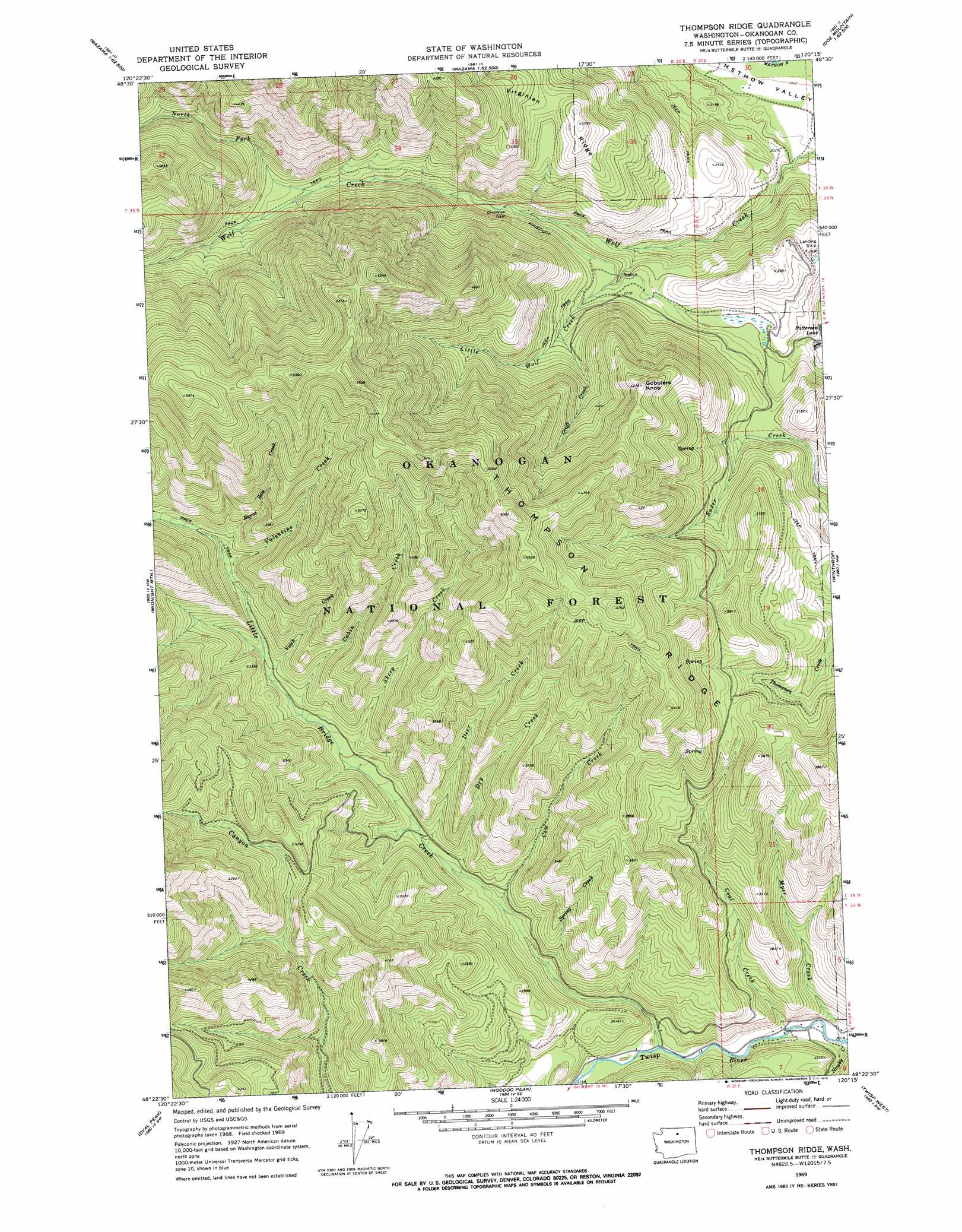
USGS Topo Quad 48120d3 - 1:24,000 scale
| Topo Map Name: | Thompson Ridge |
| USGS Topo Quad ID: | 48120d3 |
| Print Size: | ca. 21 1/4" wide x 27" high |
| Southeast Coordinates: | 48.375° N latitude / 120.25° W longitude |
| Map Center Coordinates: | 48.4375° N latitude / 120.3125° W longitude |
| U.S. State: | WA |
| Filename: | o48120d3.jpg |
| Download Map JPG Image: | Thompson Ridge topo map 1:24,000 scale |
| Map Type: | Topographic |
| Topo Series: | 7.5´ |
| Map Scale: | 1:24,000 |
| Source of Map Images: | United States Geological Survey (USGS) |
| Alternate Map Versions: |
Thompson Ridge WA 1969, updated 1972 Download PDF Buy paper map Thompson Ridge WA 2002, updated 2006 Download PDF Buy paper map Thompson Ridge WA 2011 Download PDF Buy paper map Thompson Ridge WA 2014 Download PDF Buy paper map |
| FStopo: | US Forest Service topo Thompson Ridge is available: Download FStopo PDF Download FStopo TIF |
1:24,000 Topo Quads surrounding Thompson Ridge
Robinson Mountain |
Mcleod Mountain |
Sweetgrass Butte |
Doe Mountain |
Spur Peak |
Silver Star Mountain |
Mazama |
Rendevous Mountain |
Lewis Butte |
Pearrygin Peak |
Gilbert |
Midnight Mountain |
Thompson Ridge |
Winthrop |
Blue Buck Mountain |
Sun Mountain |
Oval Peak |
Hoodoo Peak |
Twisp West |
Twisp East |
Lucerne |
Prince Creek |
Martin Peak |
Hungry Mountain |
Methow |
> Back to 48120a1 at 1:100,000 scale
> Back to 48120a1 at 1:250,000 scale
> Back to U.S. Topo Maps home
Thompson Ridge topo map: Gazetteer
Thompson Ridge: Areas
Wolf Creek Research Natural Area elevation 904m 2965′Thompson Ridge: Dams
Patterson Lake Dam elevation 731m 2398′Thompson Ridge: Reservoirs
Patterson Lake elevation 731m 2398′Thompson Ridge: Ridges
Thompson Ridge elevation 1449m 4753′Virginian Ridge elevation 1124m 3687′
Thompson Ridge: Streams
Burnt Saw Creek elevation 1009m 3310′Cabin Creek elevation 883m 2896′
Coal Creek elevation 622m 2040′
Cow Creek elevation 750m 2460′
Deer Creek elevation 789m 2588′
Dry Creek elevation 767m 2516′
Graff Creek elevation 894m 2933′
Little Bridge Creek elevation 653m 2142′
Little Wolf Creek elevation 730m 2395′
Myer Creek elevation 618m 2027′
Newby Creek elevation 620m 2034′
North Fork Wolf Creek elevation 934m 3064′
Sheep Creek elevation 842m 2762′
Spring Creek elevation 718m 2355′
Valentine Creek elevation 982m 3221′
Vetch Creek elevation 906m 2972′
Thompson Ridge: Summits
Gobblers Knob elevation 1299m 4261′Thompson Ridge digital topo map on disk
Buy this Thompson Ridge topo map showing relief, roads, GPS coordinates and other geographical features, as a high-resolution digital map file on DVD: