Lewis Butte Topo Map Washington
To zoom in, hover over the map of Lewis Butte
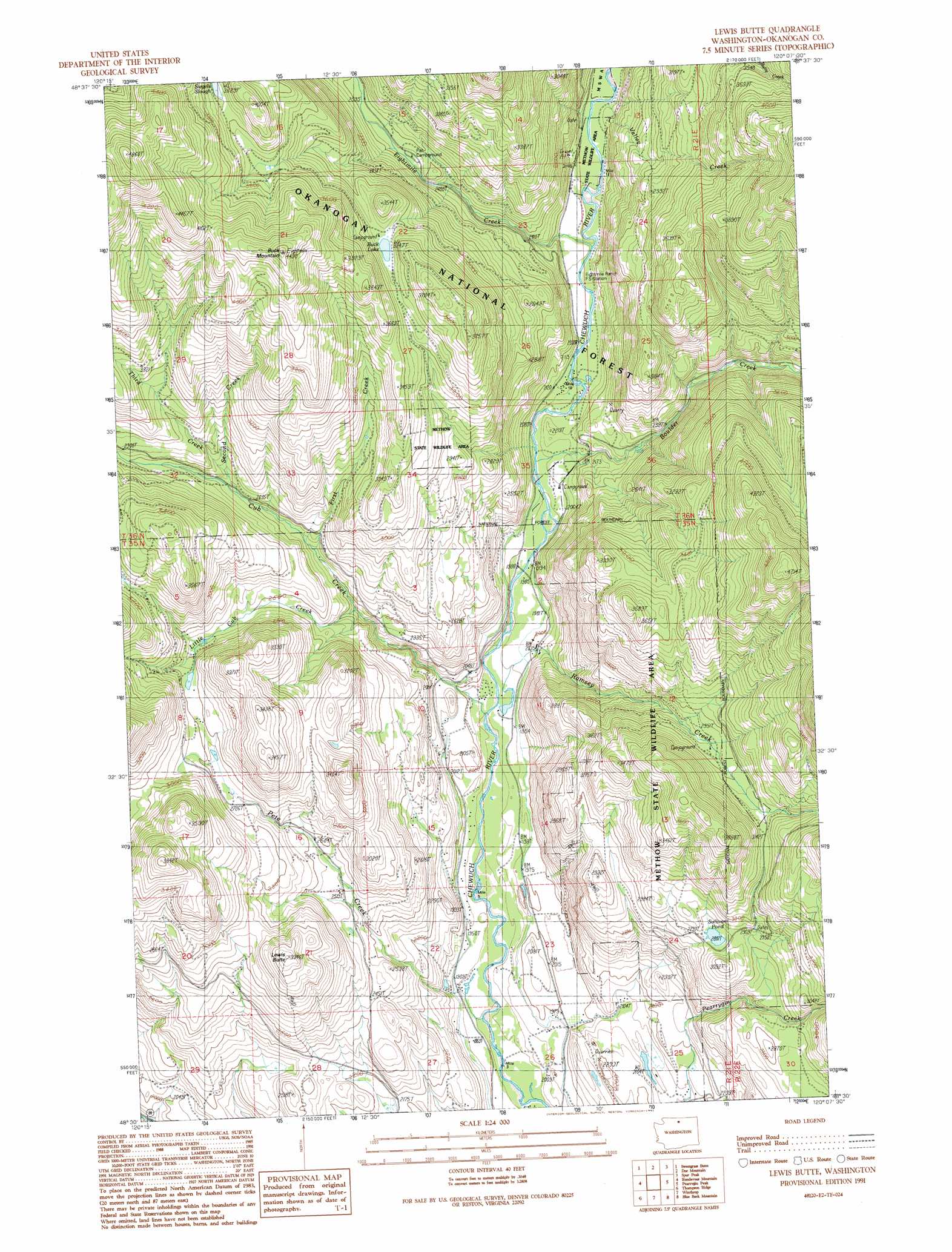
USGS Topo Quad 48120e2 - 1:24,000 scale
| Topo Map Name: | Lewis Butte |
| USGS Topo Quad ID: | 48120e2 |
| Print Size: | ca. 21 1/4" wide x 27" high |
| Southeast Coordinates: | 48.5° N latitude / 120.125° W longitude |
| Map Center Coordinates: | 48.5625° N latitude / 120.1875° W longitude |
| U.S. State: | WA |
| Filename: | o48120e2.jpg |
| Download Map JPG Image: | Lewis Butte topo map 1:24,000 scale |
| Map Type: | Topographic |
| Topo Series: | 7.5´ |
| Map Scale: | 1:24,000 |
| Source of Map Images: | United States Geological Survey (USGS) |
| Alternate Map Versions: |
Lewis Butte WA 1991, updated 1991 Download PDF Buy paper map Lewis Butte WA 2002, updated 2006 Download PDF Buy paper map Lewis Butte WA 2011 Download PDF Buy paper map Lewis Butte WA 2014 Download PDF Buy paper map |
| FStopo: | US Forest Service topo Lewis Butte is available: Download FStopo PDF Download FStopo TIF |
1:24,000 Topo Quads surrounding Lewis Butte
Lost Peak |
Billy Goat Mountain |
Mount Barney |
Coleman Peak |
Corral Butte |
Mcleod Mountain |
Sweetgrass Butte |
Doe Mountain |
Spur Peak |
Tiffany Mountain |
Mazama |
Rendevous Mountain |
Lewis Butte |
Pearrygin Peak |
Old Baldy |
Midnight Mountain |
Thompson Ridge |
Winthrop |
Blue Buck Mountain |
Loup Loup Summit |
Oval Peak |
Hoodoo Peak |
Twisp West |
Twisp East |
Thrapp Mountain |
> Back to 48120e1 at 1:100,000 scale
> Back to 48120a1 at 1:250,000 scale
> Back to U.S. Topo Maps home
Lewis Butte topo map: Gazetteer
Lewis Butte: Dams
Wright Ponds-East Pond Dam elevation 644m 2112′Wright Ponds-West Pond Dam elevation 644m 2112′
Lewis Butte: Guts
Siegels Slough elevation 1108m 3635′Lewis Butte: Lakes
Buck Lake elevation 991m 3251′Meadow Lake elevation 1290m 4232′
Sullivan Pond elevation 857m 2811′
Lewis Butte: Parks
Methow Wildlife Area elevation 1034m 3392′Lewis Butte: Reservoirs
Wright Ponds-East Pond elevation 644m 2112′Wright Ponds-West Pond elevation 644m 2112′
Lewis Butte: Streams
Boulder Creek elevation 624m 2047′Cub Creek elevation 587m 1925′
Eightmile Creek elevation 646m 2119′
First Creek elevation 753m 2470′
Little Cub Creek elevation 706m 2316′
Pete Creek elevation 558m 1830′
Ramsey Creek elevation 593m 1945′
Second Creek elevation 802m 2631′
Third Creek elevation 813m 2667′
Valley Creek elevation 657m 2155′
Lewis Butte: Summits
Buck Mountain elevation 1368m 4488′Lewis Butte elevation 1015m 3330′
Lewis Butte digital topo map on disk
Buy this Lewis Butte topo map showing relief, roads, GPS coordinates and other geographical features, as a high-resolution digital map file on DVD: