Mount Arriva Topo Map Washington
To zoom in, hover over the map of Mount Arriva
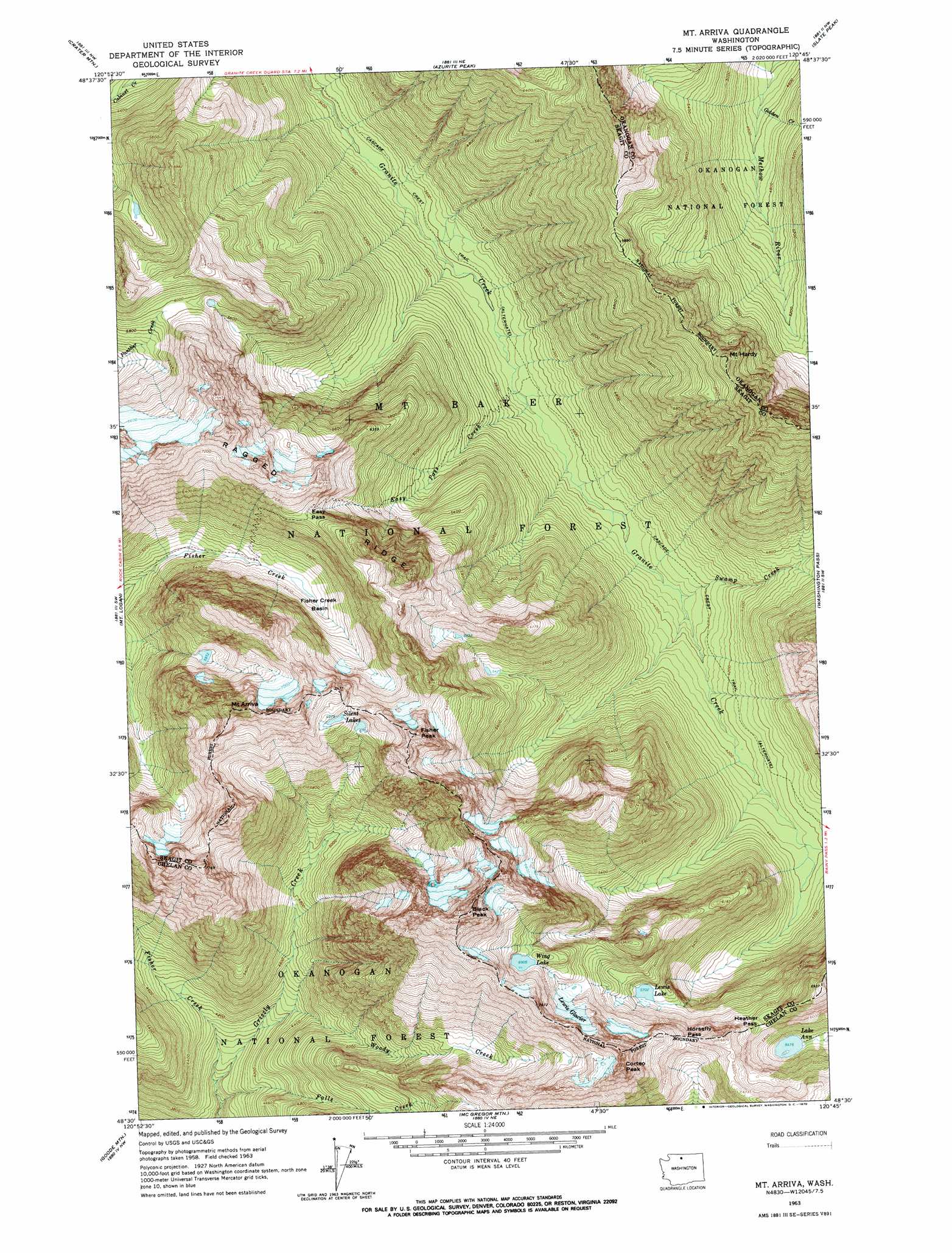
USGS Topo Quad 48120e7 - 1:24,000 scale
| Topo Map Name: | Mount Arriva |
| USGS Topo Quad ID: | 48120e7 |
| Print Size: | ca. 21 1/4" wide x 27" high |
| Southeast Coordinates: | 48.5° N latitude / 120.75° W longitude |
| Map Center Coordinates: | 48.5625° N latitude / 120.8125° W longitude |
| U.S. State: | WA |
| Filename: | o48120e7.jpg |
| Download Map JPG Image: | Mount Arriva topo map 1:24,000 scale |
| Map Type: | Topographic |
| Topo Series: | 7.5´ |
| Map Scale: | 1:24,000 |
| Source of Map Images: | United States Geological Survey (USGS) |
| Alternate Map Versions: |
Mt. Arriva WA 1963, updated 1964 Download PDF Buy paper map Mt. Arriva WA 1963, updated 1970 Download PDF Buy paper map Mt. Arriva WA 1963, updated 1970 Download PDF Buy paper map Mount Arriva WA 2002, updated 2006 Download PDF Buy paper map Mount Arriva WA 2011 Download PDF Buy paper map Mount Arriva WA 2014 Download PDF Buy paper map |
| FStopo: | US Forest Service topo Mount Arriva is available: Download FStopo PDF Download FStopo TIF |
1:24,000 Topo Quads surrounding Mount Arriva
Pumpkin Mountain |
Jack Mountain |
Shull Mountain |
Pasayten Peak |
Mount Lago |
Ross Dam |
Crater Mountain |
Azurite Peak |
Slate Peak |
Robinson Mountain |
Forbidden Peak |
Mount Logan |
Mount Arriva |
Washington Pass |
Silver Star Mountain |
Cascade Pass |
Goode Mountain |
Mcgregor Mountain |
Mcalester Mountain |
Gilbert |
Dome Peak |
Agnes Mountain |
Mount Lyall |
Stehekin |
Sun Mountain |
> Back to 48120e1 at 1:100,000 scale
> Back to 48120a1 at 1:250,000 scale
> Back to U.S. Topo Maps home
Mount Arriva topo map: Gazetteer
Mount Arriva: Basins
Fisher Creek Basin elevation 1624m 5328′Mount Arriva: Gaps
Easy Pass elevation 1987m 6519′Heather Pass elevation 1858m 6095′
Horsefly Pass elevation 1964m 6443′
Maple Pass elevation 2037m 6683′
Mesahchie Pass elevation 1825m 5987′
Mount Arriva: Glaciers
Lewis Glacier elevation 2060m 6758′Mesahchie Glacier elevation 2156m 7073′
Mount Arriva: Lakes
Ann Lake elevation 1670m 5479′Kitling Lake elevation 1766m 5793′
Lewis Lake elevation 1739m 5705′
Silent Lakes elevation 2126m 6975′
Wing Lake elevation 2106m 6909′
Mount Arriva: Ridges
Ragged Ridge elevation 2425m 7956′Mount Arriva: Streams
Easy Pass Creek elevation 1125m 3690′Falls Creek elevation 1083m 3553′
Fisher Creek elevation 1120m 3674′
Golden Creek elevation 1374m 4507′
Kitling Creek elevation 1089m 3572′
Porcupine Creek elevation 1342m 4402′
Swamp Creek elevation 1180m 3871′
West Fork Methow River elevation 1602m 5255′
Woody Creek elevation 1220m 4002′
Mount Arriva: Summits
Black Peak elevation 2719m 8920′Corteo Peak elevation 2449m 8034′
Fisher Peak elevation 2439m 8001′
Kitling Peak elevation 2440m 8005′
Mount Arriva elevation 2482m 8143′
Mount Hardy elevation 2449m 8034′
Mount Arriva: Trails
Maple Pass Trail elevation 2041m 6696′Mount Arriva digital topo map on disk
Buy this Mount Arriva topo map showing relief, roads, GPS coordinates and other geographical features, as a high-resolution digital map file on DVD: