Bauerman Ridge Topo Map Washington
To zoom in, hover over the map of Bauerman Ridge
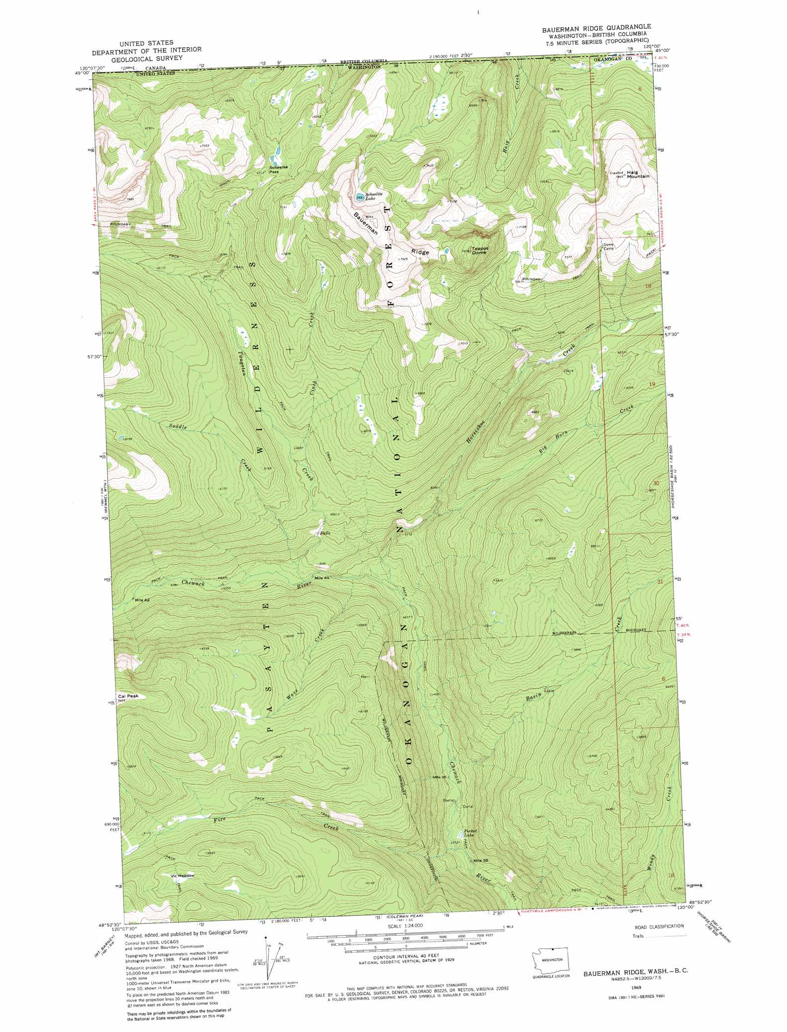
USGS Topo Quad 48120h1 - 1:24,000 scale
| Topo Map Name: | Bauerman Ridge |
| USGS Topo Quad ID: | 48120h1 |
| Print Size: | ca. 21 1/4" wide x 27" high |
| Southeast Coordinates: | 48.875° N latitude / 120° W longitude |
| Map Center Coordinates: | 48.9375° N latitude / 120.0625° W longitude |
| U.S. State: | WA |
| Filename: | o48120h1.jpg |
| Download Map JPG Image: | Bauerman Ridge topo map 1:24,000 scale |
| Map Type: | Topographic |
| Topo Series: | 7.5´ |
| Map Scale: | 1:24,000 |
| Source of Map Images: | United States Geological Survey (USGS) |
| Alternate Map Versions: |
Bauerman Ridge WA 1969, updated 1973 Download PDF Buy paper map Bauerman Ridge WA 1969, updated 1981 Download PDF Buy paper map Bauerman Ridge WA 2001, updated 2004 Download PDF Buy paper map Bauerman Ridge WA 2011 Download PDF Buy paper map Bauerman Ridge WA 2014 Download PDF Buy paper map |
| FStopo: | US Forest Service topo Bauerman Ridge is available: Download FStopo PDF Download FStopo TIF |
1:24,000 Topo Quads surrounding Bauerman Ridge
Ashnola Pass |
Remmel Mountain |
Bauerman Ridge |
Horseshoe Basin |
Hurley Peak |
Billy Goat Mountain |
Mount Barney |
Coleman Peak |
Corral Butte |
Duncan Ridge |
Sweetgrass Butte |
Doe Mountain |
Spur Peak |
Tiffany Mountain |
Coxit Mountain |
> Back to 48120e1 at 1:100,000 scale
> Back to 48120a1 at 1:250,000 scale
> Back to U.S. Topo Maps home
Bauerman Ridge topo map: Gazetteer
Bauerman Ridge: Flats
Vic Meadow elevation 1913m 6276′Bauerman Ridge: Gaps
Scheelite Pass elevation 2038m 6686′Bauerman Ridge: Lakes
Pocket Lake elevation 1326m 4350′Scheelite Lake elevation 2239m 7345′
Bauerman Ridge: Ridges
Bauerman Ridge elevation 2449m 8034′Bauerman Ridge: Streams
Basin Creek elevation 1330m 4363′Big Horn Creek elevation 1545m 5068′
Cinch Creek elevation 1708m 5603′
Fire Creek elevation 1306m 4284′
Horseshoe Creek elevation 1414m 4639′
Saddle Creek elevation 1503m 4931′
Tungsten Creek elevation 1486m 4875′
Wave Creek elevation 1442m 4730′
Bauerman Ridge: Summits
Haig Mountain elevation 2392m 7847′Teapot Dome elevation 2320m 7611′
Bauerman Ridge digital topo map on disk
Buy this Bauerman Ridge topo map showing relief, roads, GPS coordinates and other geographical features, as a high-resolution digital map file on DVD: