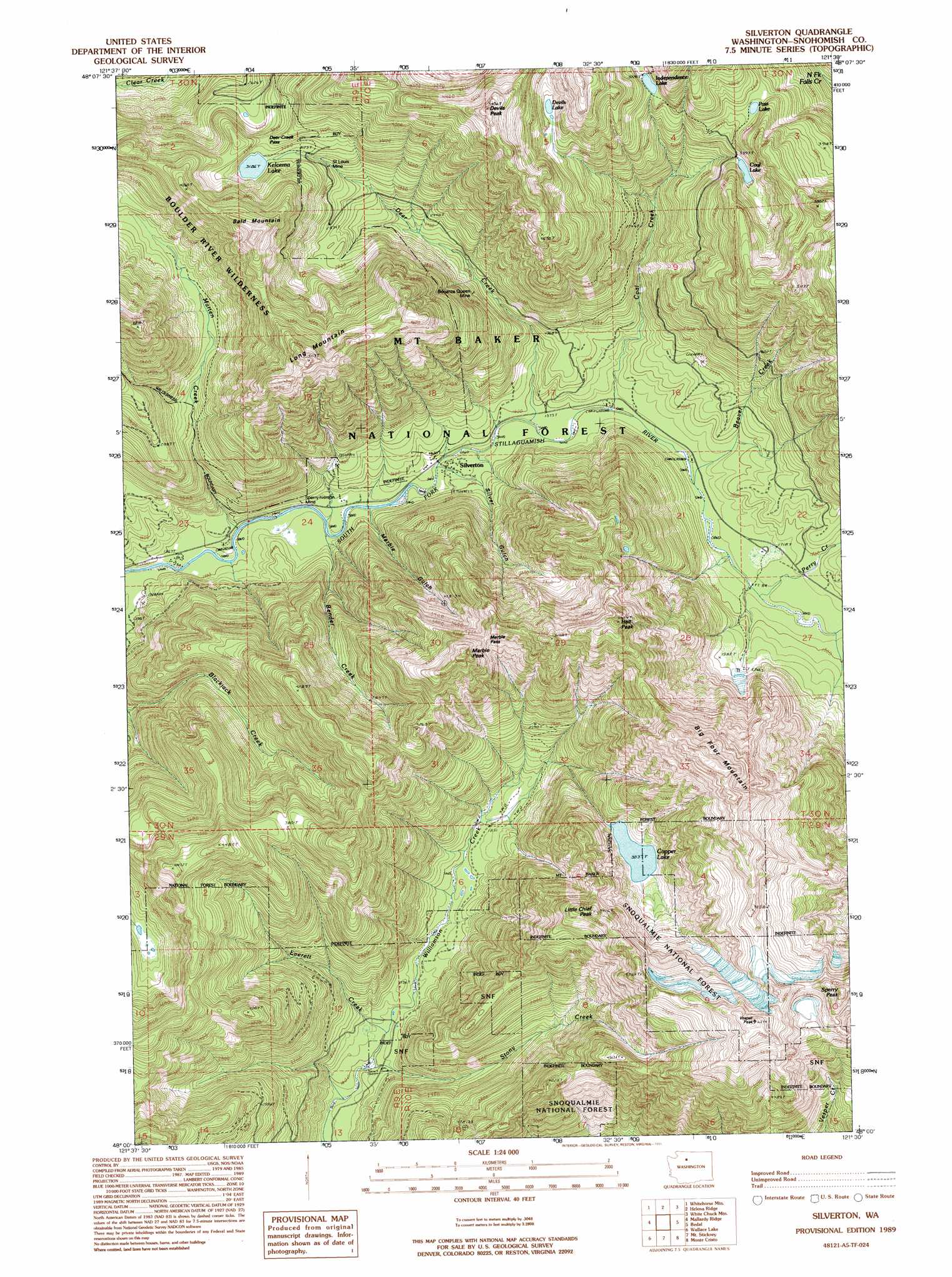
Silverton Topo Map Washington
To zoom in, hover over the map of Silverton
USGS Topo Quad 48121a5 - 1:24,000 scale
| Topo Map Name: | Silverton |
| USGS Topo Quad ID: | 48121a5 |
| Print Size: | ca. 21 1/4" wide x 27" high |
| Southeast Coordinates: | 48° N latitude / 121.5° W longitude |
| Map Center Coordinates: | 48.0625° N latitude / 121.5625° W longitude |
| U.S. State: | WA |
| Filename: | o48121a5.jpg |
| Download Map JPG Image: | Silverton topo map 1:24,000 scale |
| Map Type: | Topographic |
| Topo Series: | 7.5´ |
| Map Scale: | 1:24,000 |
| Source of Map Images: | United States Geological Survey (USGS) |
| Alternate Map Versions: |
Silverton WA 1989, updated 1989 Download PDF Buy paper map Silverton WA 1989, updated 1995 Download PDF Buy paper map Silverton WA 2011 Download PDF Buy paper map Silverton WA 2014 Download PDF Buy paper map |
| FStopo: | US Forest Service topo Silverton is available: Download FStopo PDF Download FStopo TIF |
1:24,000 Topo Quads surrounding Silverton
Mount Higgins |
Fortson |
Darrington |
Prairie Mountain |
Huckleberry Mountain |
Meadow Mountain |
Whitehorse Mountain |
Helena Ridge |
White Chuck Mountain |
Pugh Mountain |
Verlot |
Mallardy Ridge |
Silverton |
Bedal |
Sloan Peak |
Lake Chaplain |
Wallace Lake |
Mount Stickney |
Monte Cristo |
Blanca Lake |
Sultan |
Gold Bar |
Index |
Baring |
Evergreen Mountain |
> Back to 48121a1 at 1:100,000 scale
> Back to 48120a1 at 1:250,000 scale
> Back to U.S. Topo Maps home
Silverton topo map: Gazetteer
Silverton: Flats
Marble Pass elevation 1319m 4327′Silverton: Gaps
Deer Creek Pass elevation 1014m 3326′Silverton: Lakes
Coal Lake elevation 1031m 3382′Copper Lake elevation 927m 3041′
Independence Lake elevation 1131m 3710′
Kelcema Lake elevation 972m 3188′
Pass Lake elevation 1132m 3713′
Silverton: Mines
Bonanza Queen Mine elevation 704m 2309′Saint Louis Mine elevation 889m 2916′
Silverton: Populated Places
Silverton elevation 468m 1535′Silverton: Post Offices
Big Four Post Office (historical) elevation 539m 1768′Silverton Post Office (historical) elevation 468m 1535′
Silverton: Streams
Beaver Creek elevation 504m 1653′Bender Creek elevation 438m 1437′
Coal Creek elevation 490m 1607′
Deer Creek elevation 478m 1568′
Everett Creek elevation 492m 1614′
Marble Gulch elevation 502m 1646′
Marten Creek elevation 432m 1417′
Perry Creek elevation 516m 1692′
Silver Gulch elevation 496m 1627′
Stony Creek elevation 482m 1581′
Silverton: Summits
Bald Mountain elevation 1409m 4622′Big Four Mountain elevation 1880m 6167′
Devils Peak elevation 1554m 5098′
Hall Peak elevation 1561m 5121′
Little Chief Peak elevation 1593m 5226′
Long Mountain elevation 1528m 5013′
Marble Peak elevation 1531m 5022′
Sperry Peak elevation 1813m 5948′
Vesper Peak elevation 1871m 6138′
Silverton digital topo map on disk
Buy this Silverton topo map showing relief, roads, GPS coordinates and other geographical features, as a high-resolution digital map file on DVD: