Lime Mountain Topo Map Washington
To zoom in, hover over the map of Lime Mountain
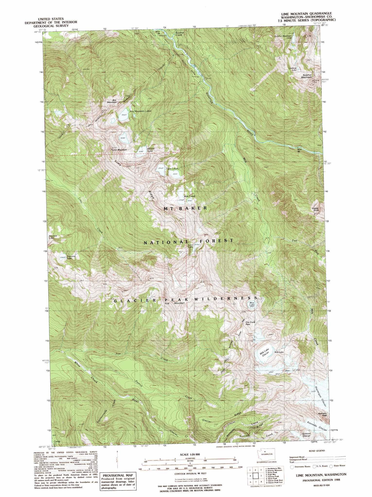
USGS Topo Quad 48121b2 - 1:24,000 scale
| Topo Map Name: | Lime Mountain |
| USGS Topo Quad ID: | 48121b2 |
| Print Size: | ca. 21 1/4" wide x 27" high |
| Southeast Coordinates: | 48.125° N latitude / 121.125° W longitude |
| Map Center Coordinates: | 48.1875° N latitude / 121.1875° W longitude |
| U.S. State: | WA |
| Filename: | o48121b2.jpg |
| Download Map JPG Image: | Lime Mountain topo map 1:24,000 scale |
| Map Type: | Topographic |
| Topo Series: | 7.5´ |
| Map Scale: | 1:24,000 |
| Source of Map Images: | United States Geological Survey (USGS) |
| Alternate Map Versions: |
Lime Mountain WA 1988, updated 1988 Download PDF Buy paper map Lime Mountain WA 1988, updated 1988 Download PDF Buy paper map Lime Mountain WA 1999, updated 2002 Download PDF Buy paper map Lime Mountain WA 2011 Download PDF Buy paper map Lime Mountain WA 2014 Download PDF Buy paper map |
| FStopo: | US Forest Service topo Lime Mountain is available: Download FStopo PDF Download FStopo TIF |
1:24,000 Topo Quads surrounding Lime Mountain
Illabot Peaks |
Snowking Mountain |
Sonny Boy Lakes |
Cascade Pass |
Goode Mountain |
Prairie Mountain |
Huckleberry Mountain |
Downey Mountain |
Dome Peak |
Agnes Mountain |
White Chuck Mountain |
Pugh Mountain |
Lime Mountain |
Gamma Peak |
Suiattle Pass |
Bedal |
Sloan Peak |
Glacier Peak West |
Glacier Peak East |
Clark Mountain |
Monte Cristo |
Blanca Lake |
Benchmark Mountain |
Poe Mountain |
Mount David |
> Back to 48121a1 at 1:100,000 scale
> Back to 48120a1 at 1:250,000 scale
> Back to U.S. Topo Maps home
Lime Mountain topo map: Gazetteer
Lime Mountain: Basins
Buckeye Basin elevation 690m 2263′Lime Mountain: Gaps
Fire Creek Pass elevation 1779m 5836′Lime Mountain: Glaciers
Milk Lake Glacier elevation 1846m 6056′Ptarmigan Glacier elevation 2319m 7608′
Lime Mountain: Lakes
Box Mountain Lakes elevation 1544m 5065′Diamond Lake elevation 1605m 5265′
Lime Lake elevation 1689m 5541′
Lookout Lake elevation 1724m 5656′
Mica Lake elevation 1660m 5446′
Milk Lake elevation 1842m 6043′
Milk Lakes elevation 1597m 5239′
Rivord Lake elevation 1628m 5341′
Sulphur Mountain Lake elevation 1581m 5187′
Twin Lakes elevation 1670m 5479′
Lime Mountain: Ridges
Glacier Ridge elevation 1544m 5065′Grassy Point elevation 1880m 6167′
Kennedy Ridge elevation 1526m 5006′
Lime Ridge elevation 2005m 6578′
Lime Mountain: Streams
East Fork Milk Creek elevation 781m 2562′Fire Creek elevation 734m 2408′
Fourteenmile Creek elevation 816m 2677′
Glacier Creek elevation 906m 2972′
Milk Creek elevation 539m 1768′
Pumice Creek elevation 772m 2532′
Sulphur Creek elevation 464m 1522′
Lime Mountain: Summits
Box Mountain elevation 1756m 5761′Fire Mountain elevation 1970m 6463′
Kennedy Peak elevation 2518m 8261′
Lime Mountain elevation 1986m 6515′
Sulphur Mountain elevation 2027m 6650′
Lime Mountain: Trails
Camp Creek Ridge Trail (historical) elevation 1454m 4770′Fire Creek Trail (historical) elevation 1631m 5351′
Fire Creek Way (historical) elevation 970m 3182′
Glacier Ridge Trail elevation 1488m 4881′
Kennedy Ridge Trail elevation 1350m 4429′
Meadow Mountain Way (historical) elevation 1800m 5905′
Sulphur Mountain Way (historical) elevation 1090m 3576′
Lime Mountain digital topo map on disk
Buy this Lime Mountain topo map showing relief, roads, GPS coordinates and other geographical features, as a high-resolution digital map file on DVD: