Pugh Mountain Topo Map Washington
To zoom in, hover over the map of Pugh Mountain
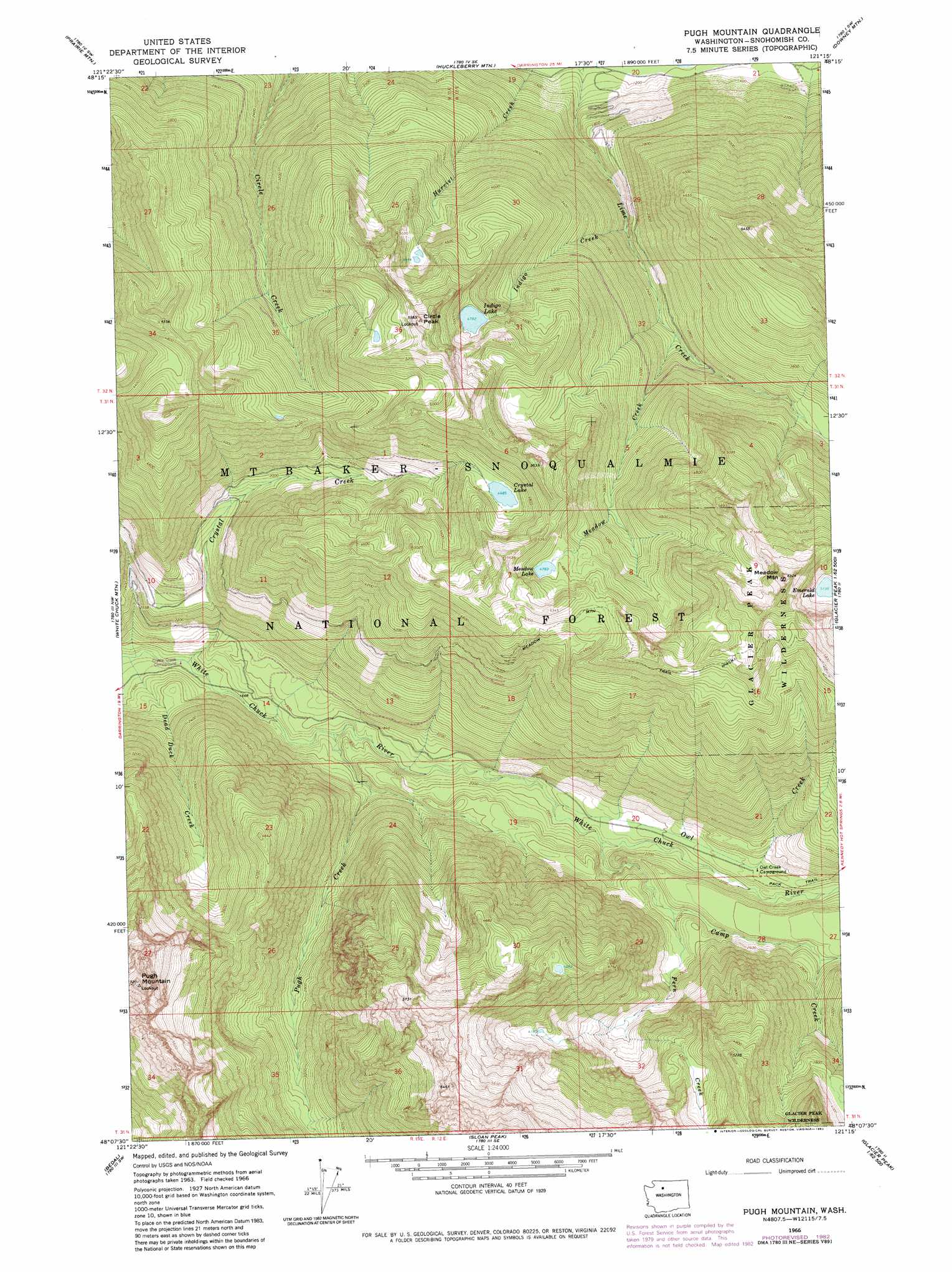
USGS Topo Quad 48121b3 - 1:24,000 scale
| Topo Map Name: | Pugh Mountain |
| USGS Topo Quad ID: | 48121b3 |
| Print Size: | ca. 21 1/4" wide x 27" high |
| Southeast Coordinates: | 48.125° N latitude / 121.25° W longitude |
| Map Center Coordinates: | 48.1875° N latitude / 121.3125° W longitude |
| U.S. State: | WA |
| Filename: | o48121b3.jpg |
| Download Map JPG Image: | Pugh Mountain topo map 1:24,000 scale |
| Map Type: | Topographic |
| Topo Series: | 7.5´ |
| Map Scale: | 1:24,000 |
| Source of Map Images: | United States Geological Survey (USGS) |
| Alternate Map Versions: |
Pugh Mountain WA 1966, updated 1968 Download PDF Buy paper map Pugh Mountain WA 1966, updated 1972 Download PDF Buy paper map Pugh Mountain WA 1966, updated 1983 Download PDF Buy paper map Mount Pugh WA 1999, updated 2002 Download PDF Buy paper map Mount Pugh WA 2011 Download PDF Buy paper map Mount Pugh WA 2014 Download PDF Buy paper map |
| FStopo: | US Forest Service topo Mount Pugh is available: Download FStopo PDF Download FStopo TIF |
1:24,000 Topo Quads surrounding Pugh Mountain
Rockport |
Illabot Peaks |
Snowking Mountain |
Sonny Boy Lakes |
Cascade Pass |
Darrington |
Prairie Mountain |
Huckleberry Mountain |
Downey Mountain |
Dome Peak |
Helena Ridge |
White Chuck Mountain |
Pugh Mountain |
Lime Mountain |
Gamma Peak |
Silverton |
Bedal |
Sloan Peak |
Glacier Peak West |
Glacier Peak East |
Mount Stickney |
Monte Cristo |
Blanca Lake |
Benchmark Mountain |
Poe Mountain |
> Back to 48121a1 at 1:100,000 scale
> Back to 48120a1 at 1:250,000 scale
> Back to U.S. Topo Maps home
Pugh Mountain topo map: Gazetteer
Pugh Mountain: Forests
Darrington Ranger District elevation 1283m 4209′Pugh Mountain: Lakes
Crystal Lake elevation 1368m 4488′Emerald Lake elevation 1567m 5141′
Indigo Lake elevation 1459m 4786′
Meadow Lake elevation 1459m 4786′
Pugh Mountain: Streams
Camp Creek elevation 618m 2027′Crystal Creek elevation 458m 1502′
Dead Duck Creek elevation 452m 1482′
Fern Creek elevation 718m 2355′
Indigo Creek elevation 684m 2244′
Meadow Creek elevation 764m 2506′
Owl Creek elevation 604m 1981′
Pugh Creek elevation 507m 1663′
Pugh Mountain: Summits
Circle Peak elevation 1747m 5731′Meadow Mountain elevation 1920m 6299′
Mount Pugh elevation 2191m 7188′
Pugh Mountain: Trails
Meadow Mountain Trail elevation 1601m 5252′Pugh Mountain digital topo map on disk
Buy this Pugh Mountain topo map showing relief, roads, GPS coordinates and other geographical features, as a high-resolution digital map file on DVD: