Grandy Lake Topo Map Washington
To zoom in, hover over the map of Grandy Lake
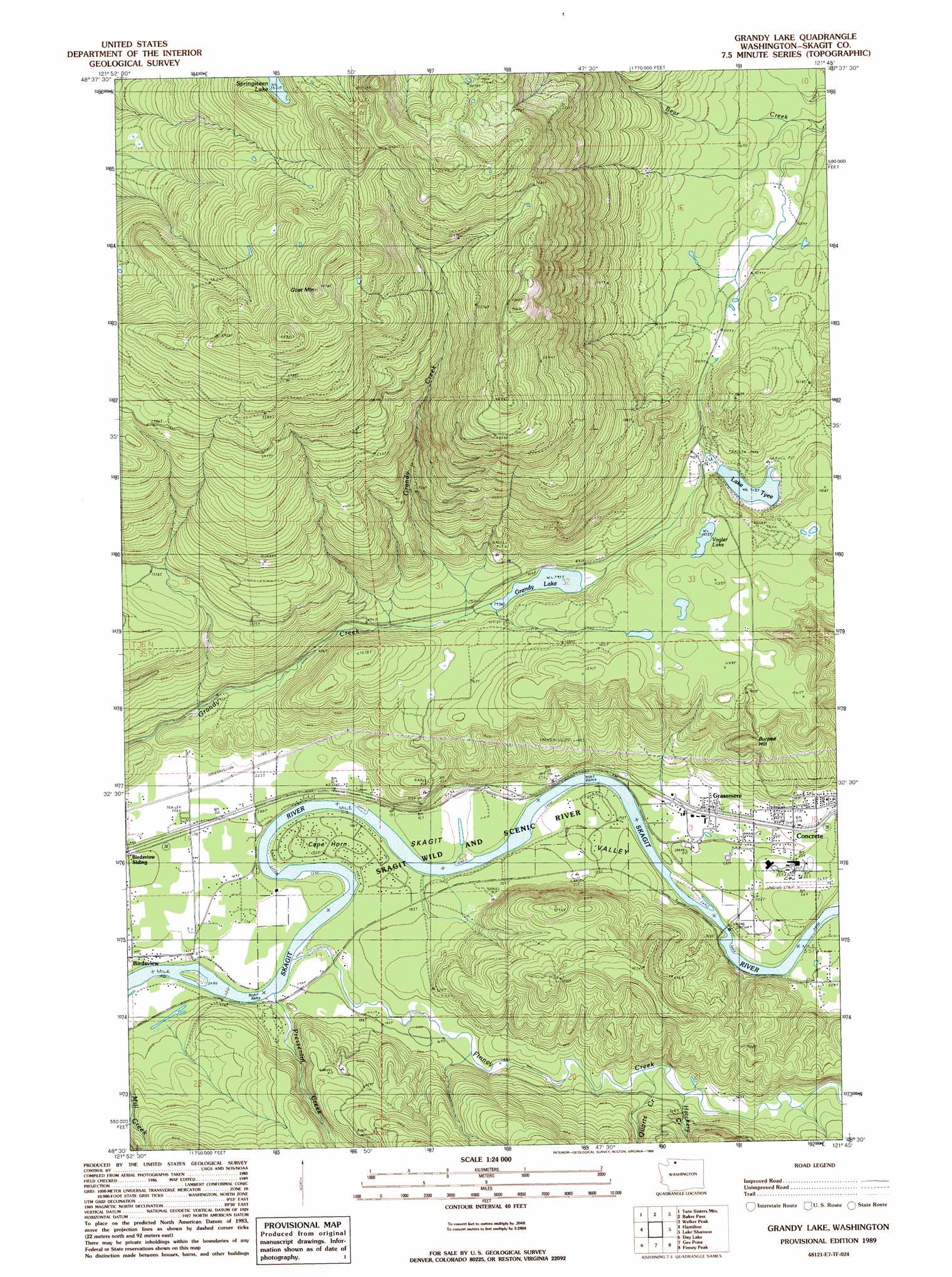
USGS Topo Quad 48121e7 - 1:24,000 scale
| Topo Map Name: | Grandy Lake |
| USGS Topo Quad ID: | 48121e7 |
| Print Size: | ca. 21 1/4" wide x 27" high |
| Southeast Coordinates: | 48.5° N latitude / 121.75° W longitude |
| Map Center Coordinates: | 48.5625° N latitude / 121.8125° W longitude |
| U.S. State: | WA |
| Filename: | o48121e7.jpg |
| Download Map JPG Image: | Grandy Lake topo map 1:24,000 scale |
| Map Type: | Topographic |
| Topo Series: | 7.5´ |
| Map Scale: | 1:24,000 |
| Source of Map Images: | United States Geological Survey (USGS) |
| Alternate Map Versions: |
Grandy Lake WA 1989, updated 1989 Download PDF Buy paper map Grandy Lake WA 2011 Download PDF Buy paper map Grandy Lake WA 2014 Download PDF Buy paper map |
| FStopo: | US Forest Service topo Grandy Lake is available: Download FStopo PDF Download FStopo TIF |
1:24,000 Topo Quads surrounding Grandy Lake
Canyon Lake |
Groat Mountain |
Mount Baker |
Shuksan Arm |
Mount Shuksan |
Cavanaugh Creek |
Twin Sisters Mountain |
Baker Pass |
Welker Peak |
Bacon Peak |
Lyman |
Hamilton |
Grandy Lake |
Lake Shannon |
Sauk Mountain |
Haystack Mountain |
Day Lake |
Gee Point |
Finney Peak |
Rockport |
Stimson Hill |
Oso |
Mount Higgins |
Fortson |
Darrington |
> Back to 48121e1 at 1:100,000 scale
> Back to 48120a1 at 1:250,000 scale
> Back to U.S. Topo Maps home
Grandy Lake topo map: Gazetteer
Grandy Lake: Airports
Concrete Municipal Airport elevation 66m 216′Grandy Lake: Bridges
Dalles Bridge elevation 48m 157′Grandy Lake: Capes
Cape Horn elevation 50m 164′Grandy Lake: Dams
Skagit Lake Dam elevation 280m 918′Grandy Lake: Lakes
Grandy Lake elevation 244m 800′Lake Tyee elevation 279m 915′
Vogler Lake elevation 329m 1079′
Grandy Lake: Populated Places
Grassmere elevation 67m 219′Grandy Lake: Reservoirs
Skagit Lake elevation 280m 918′Grandy Lake: Streams
Finney Creek elevation 44m 144′Hatchery Creek elevation 72m 236′
Pressentin Creek elevation 39m 127′
Quartz Creek elevation 75m 246′
Grandy Lake: Summits
Burpee Hill elevation 306m 1003′Goat Mountain elevation 1454m 4770′
Grandy Lake digital topo map on disk
Buy this Grandy Lake topo map showing relief, roads, GPS coordinates and other geographical features, as a high-resolution digital map file on DVD: