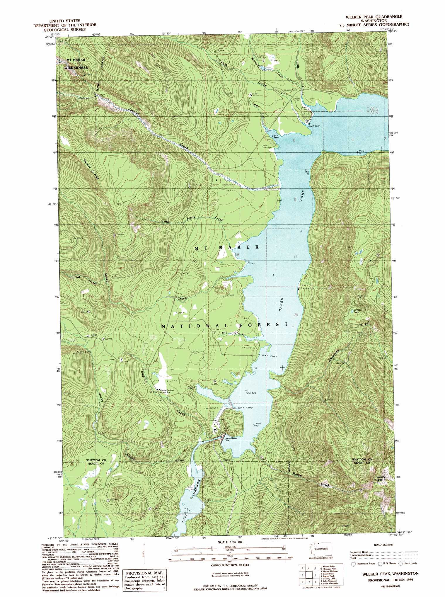
Welker Peak Topo Map Washington
To zoom in, hover over the map of Welker Peak
USGS Topo Quad 48121f6 - 1:24,000 scale
| Topo Map Name: | Welker Peak |
| USGS Topo Quad ID: | 48121f6 |
| Print Size: | ca. 21 1/4" wide x 27" high |
| Southeast Coordinates: | 48.625° N latitude / 121.625° W longitude |
| Map Center Coordinates: | 48.6875° N latitude / 121.6875° W longitude |
| U.S. State: | WA |
| Filename: | o48121f6.jpg |
| Download Map JPG Image: | Welker Peak topo map 1:24,000 scale |
| Map Type: | Topographic |
| Topo Series: | 7.5´ |
| Map Scale: | 1:24,000 |
| Source of Map Images: | United States Geological Survey (USGS) |
| Alternate Map Versions: |
Welker Peak WA 1989, updated 1989 Download PDF Buy paper map Welker Peak WA 2011 Download PDF Buy paper map Welker Peak WA 2014 Download PDF Buy paper map |
| FStopo: | US Forest Service topo Welker Peak is available: Download FStopo PDF Download FStopo TIF |
1:24,000 Topo Quads surrounding Welker Peak
Glacier |
Bearpaw Mountain |
Mount Larrabee |
Mount Sefrit |
Copper Mountain |
Groat Mountain |
Mount Baker |
Shuksan Arm |
Mount Shuksan |
Mount Blum |
Twin Sisters Mountain |
Baker Pass |
Welker Peak |
Bacon Peak |
Damnation Peak |
Hamilton |
Grandy Lake |
Lake Shannon |
Sauk Mountain |
Marblemount |
Day Lake |
Gee Point |
Finney Peak |
Rockport |
Illabot Peaks |
> Back to 48121e1 at 1:100,000 scale
> Back to 48120a1 at 1:250,000 scale
> Back to U.S. Topo Maps home
Welker Peak topo map: Gazetteer
Welker Peak: Dams
Rocky Creek Dam elevation 525m 1722′Upper Baker Dam elevation 222m 728′
West Pass Dike Dam elevation 221m 725′
Welker Peak: Forests
Mount Baker Ranger District elevation 804m 2637′Welker Peak: Lakes
Lilypad Lake elevation 929m 3047′Welker Peak: Rapids
Marble Rapids elevation 221m 725′Welker Peak: Reservoirs
Baker Lake elevation 221m 725′Welker Peak: Ridges
Forest Divide elevation 1200m 3937′Welker Peak: Streams
Anderson Creek elevation 221m 725′Boulder Creek elevation 224m 734′
Dillard Creek elevation 441m 1446′
Little Park Creek elevation 221m 725′
Little Sandy Creek elevation 221m 725′
Morovitz Creek elevation 235m 770′
Park Creek elevation 221m 725′
Rocky Creek elevation 139m 456′
Sandy Creek elevation 221m 725′
Sulphur Creek elevation 139m 456′
Swift Creek elevation 221m 725′
Welker Creek elevation 221m 725′
Welker Peak: Summits
Welker Peak elevation 1693m 5554′Welker Peak digital topo map on disk
Buy this Welker Peak topo map showing relief, roads, GPS coordinates and other geographical features, as a high-resolution digital map file on DVD: