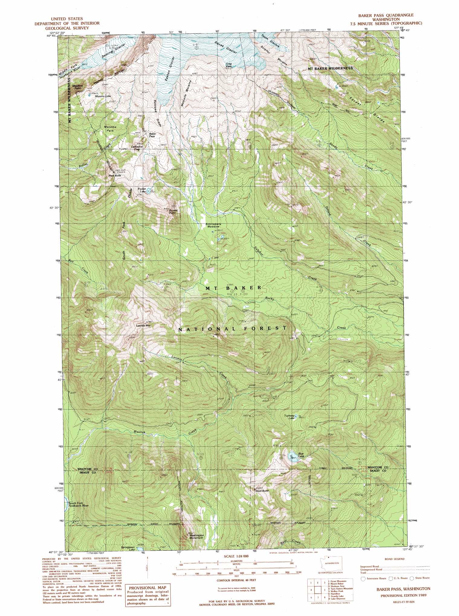
Baker Pass Topo Map Washington
To zoom in, hover over the map of Baker Pass
USGS Topo Quad 48121f7 - 1:24,000 scale
| Topo Map Name: | Baker Pass |
| USGS Topo Quad ID: | 48121f7 |
| Print Size: | ca. 21 1/4" wide x 27" high |
| Southeast Coordinates: | 48.625° N latitude / 121.75° W longitude |
| Map Center Coordinates: | 48.6875° N latitude / 121.8125° W longitude |
| U.S. State: | WA |
| Filename: | o48121f7.jpg |
| Download Map JPG Image: | Baker Pass topo map 1:24,000 scale |
| Map Type: | Topographic |
| Topo Series: | 7.5´ |
| Map Scale: | 1:24,000 |
| Source of Map Images: | United States Geological Survey (USGS) |
| Alternate Map Versions: |
Baker Pass WA 1989, updated 1989 Download PDF Buy paper map Baker Pass WA 1989, updated 1989 Download PDF Buy paper map Baker Pass WA 2011 Download PDF Buy paper map Baker Pass WA 2014 Download PDF Buy paper map |
| FStopo: | US Forest Service topo Baker Pass is available: Download FStopo PDF Download FStopo TIF |
1:24,000 Topo Quads surrounding Baker Pass
Maple Falls |
Glacier |
Bearpaw Mountain |
Mount Larrabee |
Mount Sefrit |
Canyon Lake |
Groat Mountain |
Mount Baker |
Shuksan Arm |
Mount Shuksan |
Cavanaugh Creek |
Twin Sisters Mountain |
Baker Pass |
Welker Peak |
Bacon Peak |
Lyman |
Hamilton |
Grandy Lake |
Lake Shannon |
Sauk Mountain |
Haystack Mountain |
Day Lake |
Gee Point |
Finney Peak |
Rockport |
> Back to 48121e1 at 1:100,000 scale
> Back to 48120a1 at 1:250,000 scale
> Back to U.S. Topo Maps home
Baker Pass topo map: Gazetteer
Baker Pass: Cliffs
Cathedral Crag elevation 1531m 5022′Meadow Point elevation 1627m 5337′
Baker Pass: Flats
Mazama Park elevation 1368m 4488′Schriebers Meadow elevation 1066m 3497′
Baker Pass: Gaps
Baker Pass elevation 1510m 4954′Baker Pass: Glaciers
Easton Glacier elevation 1949m 6394′Squak Glacier elevation 1998m 6555′
Baker Pass: Lakes
Baby Lake elevation 1347m 4419′Blue Lake elevation 1216m 3989′
Mazama Lake elevation 1564m 5131′
Pocket Lake elevation 1399m 4589′
Springsteen Lake elevation 1101m 3612′
Tuckway Lake elevation 1152m 3779′
Baker Pass: Pillars
Washington Monument elevation 1358m 4455′Baker Pass: Ridges
Metcalfe Moraine elevation 1806m 5925′South Fork Divide elevation 1473m 4832′
Sulphur Moraine elevation 1707m 5600′
Baker Pass: Streams
Loomis Creek elevation 788m 2585′Baker Pass: Summits
Dock Butte elevation 1512m 4960′Loomis Mountain elevation 1640m 5380′
Park Butte elevation 1641m 5383′
Railroad Grade elevation 1613m 5291′
Survey Point elevation 1531m 5022′
Baker Pass digital topo map on disk
Buy this Baker Pass topo map showing relief, roads, GPS coordinates and other geographical features, as a high-resolution digital map file on DVD: