Mount Larrabee Topo Map Washington
To zoom in, hover over the map of Mount Larrabee
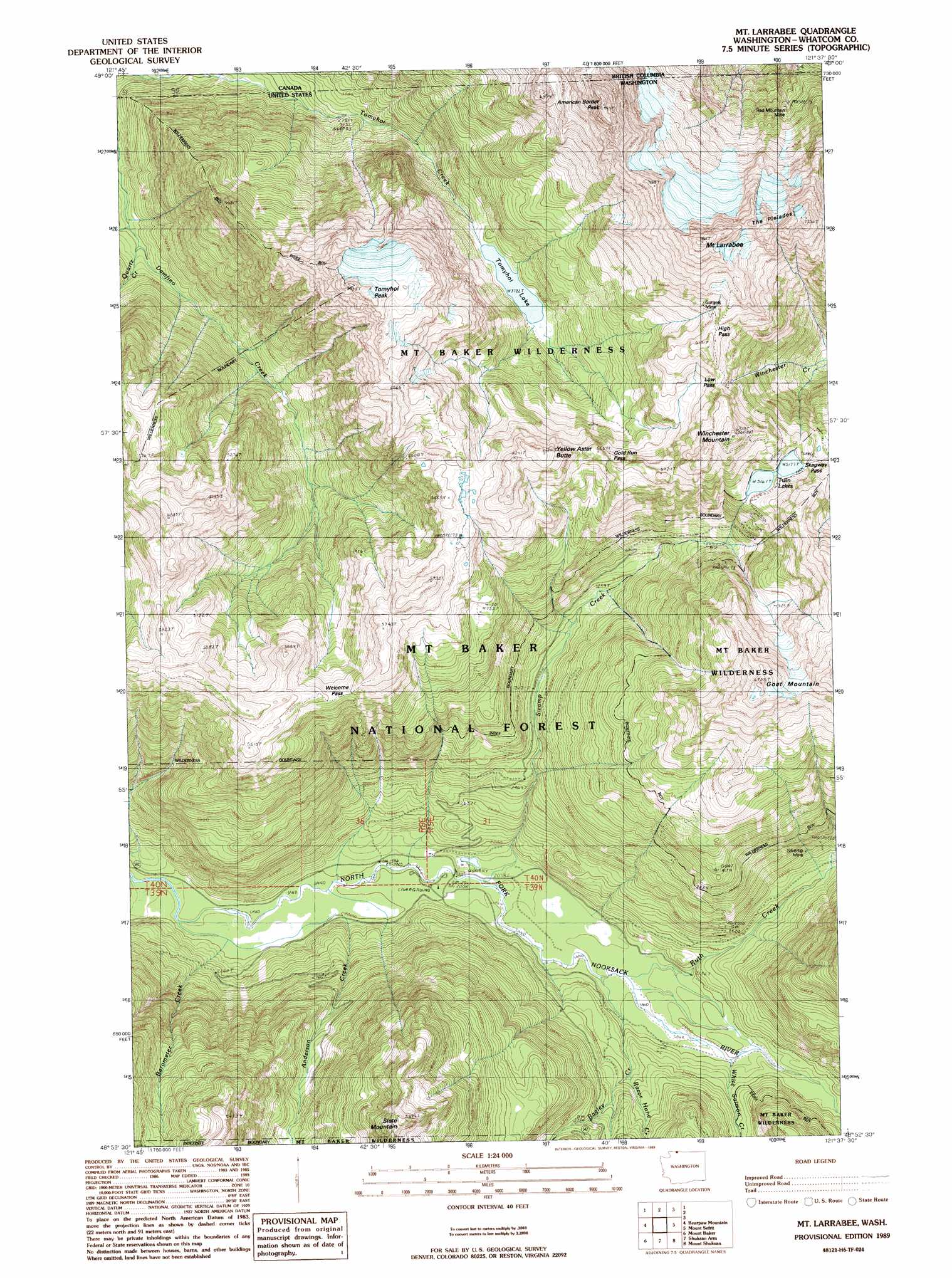
USGS Topo Quad 48121h6 - 1:24,000 scale
| Topo Map Name: | Mount Larrabee |
| USGS Topo Quad ID: | 48121h6 |
| Print Size: | ca. 21 1/4" wide x 27" high |
| Southeast Coordinates: | 48.875° N latitude / 121.625° W longitude |
| Map Center Coordinates: | 48.9375° N latitude / 121.6875° W longitude |
| U.S. State: | WA |
| Filename: | o48121h6.jpg |
| Download Map JPG Image: | Mount Larrabee topo map 1:24,000 scale |
| Map Type: | Topographic |
| Topo Series: | 7.5´ |
| Map Scale: | 1:24,000 |
| Source of Map Images: | United States Geological Survey (USGS) |
| Alternate Map Versions: |
Mt Larrabee WA 1989, updated 1989 Download PDF Buy paper map Mt Larrabee WA 1989, updated 1989 Download PDF Buy paper map Mount Larrabee WA 2011 Download PDF Buy paper map Mount Larrabee WA 2014 Download PDF Buy paper map |
| FStopo: | US Forest Service topo Mount Larrabee is available: Download FStopo PDF Download FStopo TIF |
1:24,000 Topo Quads surrounding Mount Larrabee
Glacier |
Bearpaw Mountain |
Mount Larrabee |
Mount Sefrit |
Copper Mountain |
Groat Mountain |
Mount Baker |
Shuksan Arm |
Mount Shuksan |
Mount Blum |
Twin Sisters Mountain |
Baker Pass |
Welker Peak |
Bacon Peak |
Damnation Peak |
> Back to 48121e1 at 1:100,000 scale
> Back to 48120a1 at 1:250,000 scale
> Back to U.S. Topo Maps home
Mount Larrabee topo map: Gazetteer
Mount Larrabee: Gaps
Gold Run Pass elevation 1654m 5426′High Pass elevation 1752m 5748′
Low Pass elevation 1717m 5633′
Skagway Pass elevation 1599m 5246′
Welcome Pass elevation 1567m 5141′
Mount Larrabee: Lakes
Tomyhoi Lake elevation 1136m 3727′Twin Lakes elevation 1577m 5173′
Mount Larrabee: Mines
Gargett Mine elevation 1741m 5711′Red Mountain Mine elevation 1262m 4140′
Silvertip Mine elevation 909m 2982′
Mount Larrabee: Streams
Anderson Creek elevation 603m 1978′Bagley Creek elevation 634m 2080′
Barometer Creek elevation 595m 1952′
Galena Creek elevation 780m 2559′
Quartz Creek elevation 793m 2601′
Razor Hone Creek elevation 718m 2355′
Ruth Creek elevation 637m 2089′
Swamp Creek elevation 619m 2030′
White Salmon Creek elevation 673m 2208′
Mount Larrabee: Summits
American Border Peak elevation 2436m 7992′Goat Mountain elevation 2076m 6811′
Mount Larrabee elevation 2384m 7821′
Slate Mountain elevation 1633m 5357′
The Pleiades elevation 2193m 7194′
Tomyhoi Peak elevation 2223m 7293′
Winchester Mountain elevation 1978m 6489′
Yellow Aster Butte elevation 1868m 6128′
Mount Larrabee digital topo map on disk
Buy this Mount Larrabee topo map showing relief, roads, GPS coordinates and other geographical features, as a high-resolution digital map file on DVD: