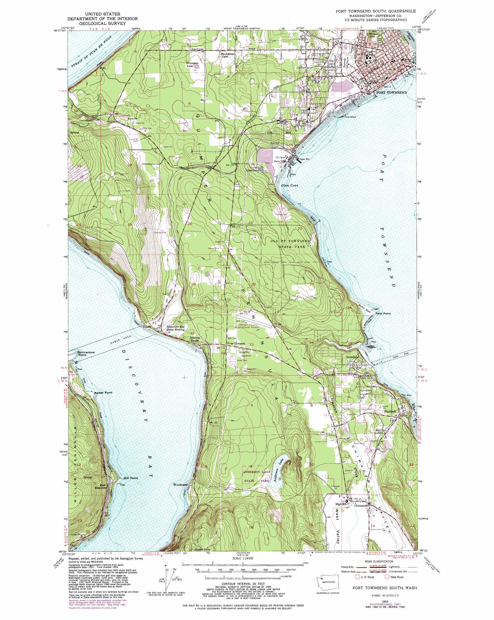
Port Townsend South Topo Map Washington
To zoom in, hover over the map of Port Townsend South
USGS Topo Quad 48122a7 - 1:24,000 scale
| Topo Map Name: | Port Townsend South |
| USGS Topo Quad ID: | 48122a7 |
| Print Size: | ca. 21 1/4" wide x 27" high |
| Southeast Coordinates: | 48° N latitude / 122.75° W longitude |
| Map Center Coordinates: | 48.0625° N latitude / 122.8125° W longitude |
| U.S. State: | WA |
| Filename: | o48122a7.jpg |
| Download Map JPG Image: | Port Townsend South topo map 1:24,000 scale |
| Map Type: | Topographic |
| Topo Series: | 7.5´ |
| Map Scale: | 1:24,000 |
| Source of Map Images: | United States Geological Survey (USGS) |
| Alternate Map Versions: |
Port Townsend South WA 1953, updated 1955 Download PDF Buy paper map Port Townsend South WA 1953, updated 1972 Download PDF Buy paper map Port Townsend South WA 1953, updated 1976 Download PDF Buy paper map Port Townsend South WA 1953, updated 1982 Download PDF Buy paper map Port Townsend South WA 2011 Download PDF Buy paper map Port Townsend South WA 2014 Download PDF Buy paper map |
1:24,000 Topo Quads surrounding Port Townsend South
Smith Island |
Oak Harbor |
Crescent Harbor |
||
Dungeness |
Port Townsend North |
Coupeville |
Camano |
|
Sequim |
Gardiner |
Port Townsend South |
Nordland |
Freeland |
Mount Zion |
Uncas |
Center |
Port Ludlow |
Hansville |
Mount Townsend |
Mount Walker |
Quilcene |
Lofall |
Port Gamble |
> Back to 48122a1 at 1:100,000 scale
> Back to 48122a1 at 1:250,000 scale
> Back to U.S. Topo Maps home
Port Townsend South topo map: Gazetteer
Port Townsend South: Airports
Hadlock Airport elevation 35m 114′Jefferson County International Airport elevation 33m 108′
Jefferson General Hospital Heliport elevation 55m 180′
Port Townsend South: Bars
Kuhn Spit elevation 3m 9′Port Townsend South: Bays
Glen Cove elevation 0m 0′Port Townsend elevation 0m 0′
Port Townsend South: Capes
Contractors Point elevation 3m 9′Kala Point elevation 2m 6′
Kalset Point elevation 1m 3′
Mill Point elevation -3m -10′
Quimper Peninsula elevation 72m 236′
Port Townsend South: Dams
Morgan Hill Reservoir Dam elevation 81m 265′Port Townsend South: Lakes
Anderson Lake elevation 78m 255′Buckmans Lake elevation 45m 147′
Strangers Lake elevation 44m 144′
Port Townsend South: Parks
Anderson Lake State Park elevation 78m 255′Chetzemolka Park elevation 16m 52′
Old Fort Townsend State Park elevation 59m 193′
Sather Park elevation 75m 246′
Port Townsend South: Populated Places
Adelma Beach elevation 20m 65′Chimacum elevation 37m 121′
Four Corners elevation 42m 137′
Glen Cove elevation 7m 22′
Irondale elevation 30m 98′
McGees (historical) elevation 82m 269′
Port Discovery elevation 37m 121′
Port Hadlock elevation 40m 131′
Port Townsend elevation 40m 131′
Tukey elevation 20m 65′
Woodmans elevation 3m 9′
Port Townsend South: Reservoirs
Morgan Hill Reservoir elevation 81m 265′Port Townsend South: Streams
Chimacum Creek elevation 2m 6′Contractors Creek elevation 2m 6′
Port Townsend South: Summits
Morgan Hill elevation 83m 272′Port Townsend South: Valleys
Chimacum Valley elevation 19m 62′West Valley elevation 40m 131′
Port Townsend South digital topo map on disk
Buy this Port Townsend South topo map showing relief, roads, GPS coordinates and other geographical features, as a high-resolution digital map file on DVD: