La Conner Topo Map Washington
To zoom in, hover over the map of La Conner
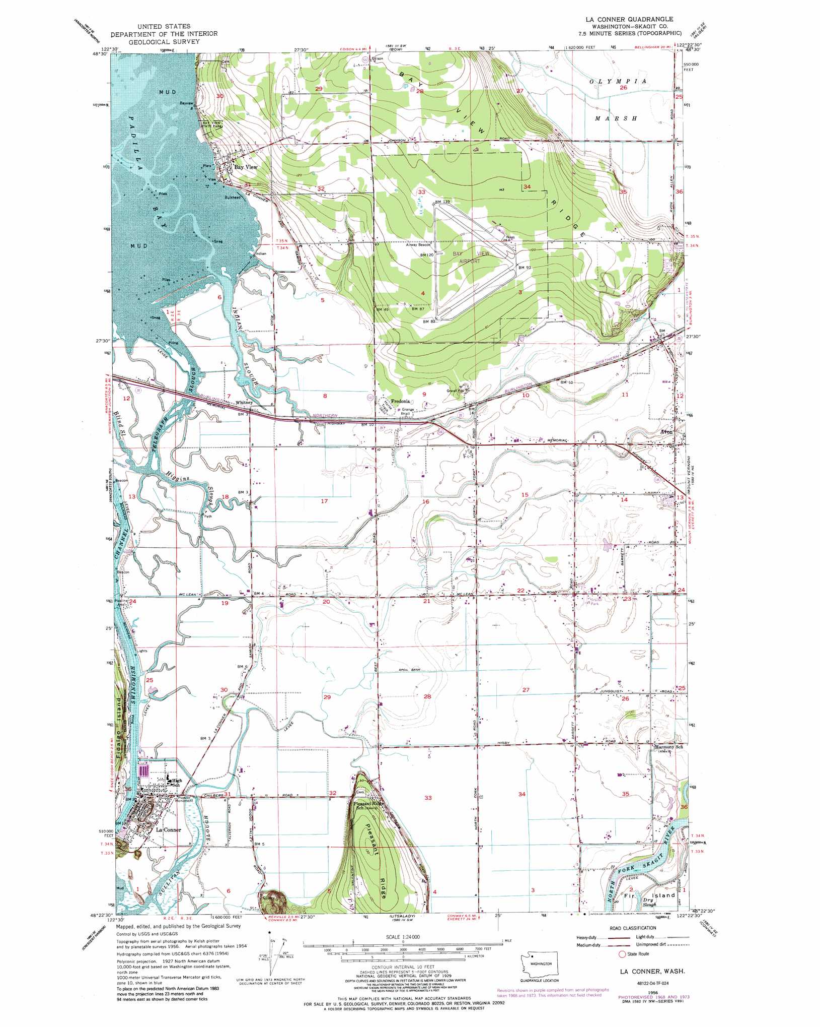
USGS Topo Quad 48122d4 - 1:24,000 scale
| Topo Map Name: | La Conner |
| USGS Topo Quad ID: | 48122d4 |
| Print Size: | ca. 21 1/4" wide x 27" high |
| Southeast Coordinates: | 48.375° N latitude / 122.375° W longitude |
| Map Center Coordinates: | 48.4375° N latitude / 122.4375° W longitude |
| U.S. State: | WA |
| Filename: | o48122d4.jpg |
| Download Map JPG Image: | La Conner topo map 1:24,000 scale |
| Map Type: | Topographic |
| Topo Series: | 7.5´ |
| Map Scale: | 1:24,000 |
| Source of Map Images: | United States Geological Survey (USGS) |
| Alternate Map Versions: |
La Conner WA 1956, updated 1958 Download PDF Buy paper map La Conner WA 1956, updated 1969 Download PDF Buy paper map La Conner WA 1956, updated 1976 Download PDF Buy paper map La Conner WA 1956, updated 1988 Download PDF Buy paper map La Conner WA 1998, updated 2002 Download PDF Buy paper map La Conner WA 2011 Download PDF Buy paper map La Conner WA 2014 Download PDF Buy paper map |
1:24,000 Topo Quads surrounding La Conner
Lummi Island |
Eliza Island |
Bellingham South |
Lake Whatcom |
Acme |
Cypress Island |
Anacortes North |
Bow |
Alger |
Sedro-Woolley North |
Deception Pass |
Anacortes South |
La Conner |
Mount Vernon |
Sedro-Woolley South |
Oak Harbor |
Crescent Harbor |
Utsalady |
Conway |
Mcmurray |
Coupeville |
Camano |
Juniper Beach |
Stanwood |
Arlington West |
> Back to 48122a1 at 1:100,000 scale
> Back to 48122a1 at 1:250,000 scale
> Back to U.S. Topo Maps home
La Conner topo map: Gazetteer
La Conner: Airports
Bay View Airport elevation 34m 111′Skagit Regional Airport elevation 31m 101′
La Conner: Channels
Swinomish Channel elevation 0m 0′La Conner: Flats
La Conner Flats elevation 2m 6′La Conner: Guts
Higgins Slough elevation 2m 6′Sullivan Slough elevation 0m 0′
Telegraph Slough elevation 1m 3′
La Conner: Parks
Bay View State Park elevation 14m 45′La Conner: Populated Places
Avon elevation 9m 29′Bay View elevation 7m 22′
Fredonia elevation 4m 13′
La Conner elevation 17m 55′
Whitney elevation 3m 9′
La Conner: Ridges
Pleasant Ridge elevation 38m 124′La Conner: Streams
Indian Slough elevation 0m 0′La Conner: Swamps
Olympia Marsh elevation 5m 16′La Conner digital topo map on disk
Buy this La Conner topo map showing relief, roads, GPS coordinates and other geographical features, as a high-resolution digital map file on DVD: