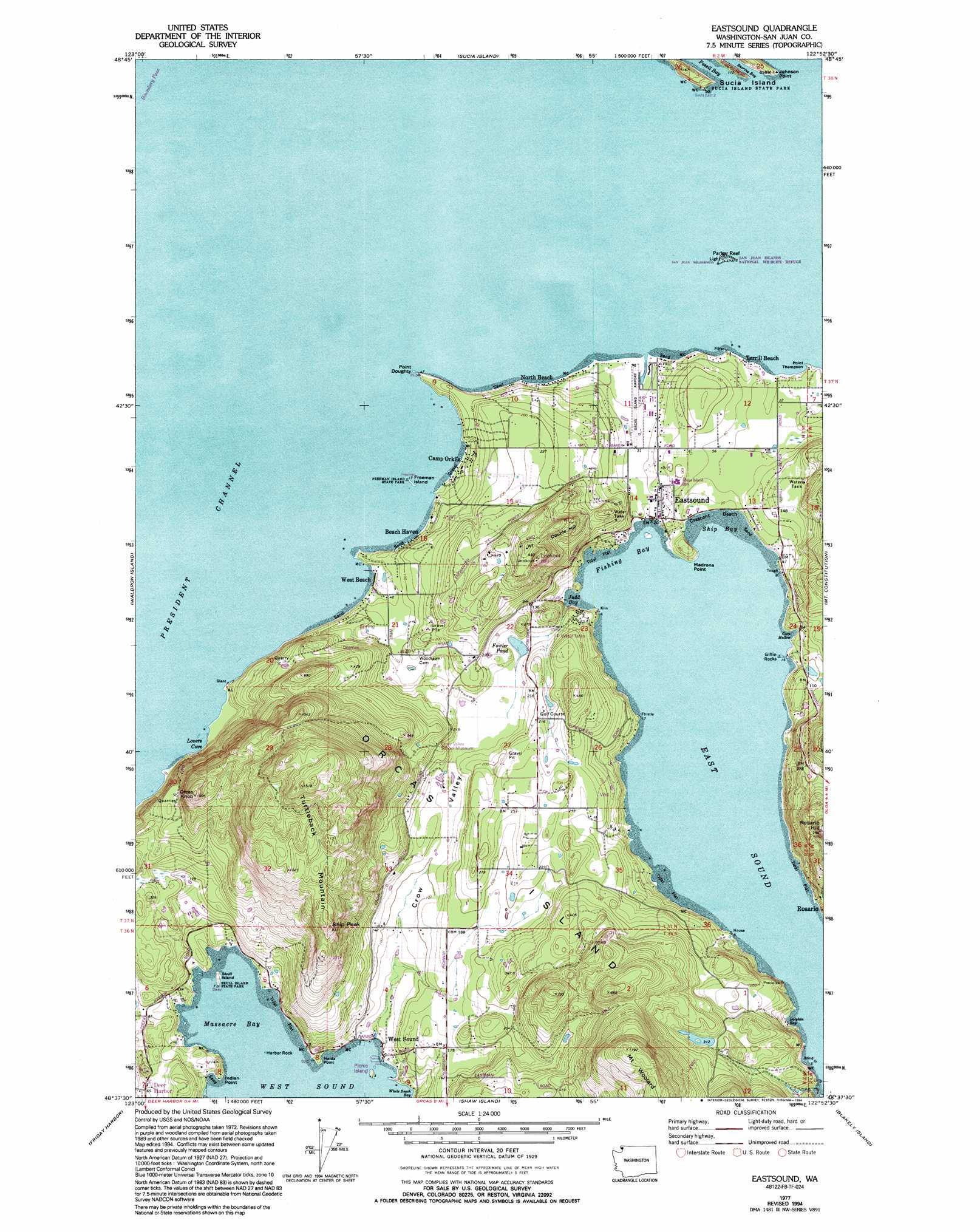
Eastsound Topo Map Washington
To zoom in, hover over the map of Eastsound
USGS Topo Quad 48122f8 - 1:24,000 scale
| Topo Map Name: | Eastsound |
| USGS Topo Quad ID: | 48122f8 |
| Print Size: | ca. 21 1/4" wide x 27" high |
| Southeast Coordinates: | 48.625° N latitude / 122.875° W longitude |
| Map Center Coordinates: | 48.6875° N latitude / 122.9375° W longitude |
| U.S. State: | WA |
| Filename: | o48122f8.jpg |
| Download Map JPG Image: | Eastsound topo map 1:24,000 scale |
| Map Type: | Topographic |
| Topo Series: | 7.5´ |
| Map Scale: | 1:24,000 |
| Source of Map Images: | United States Geological Survey (USGS) |
| Alternate Map Versions: |
Eastsound WA 1977, updated 1978 Download PDF Buy paper map Eastsound WA 1977, updated 1994 Download PDF Buy paper map Eastsound WA 1997, updated 2003 Download PDF Buy paper map Eastsound WA 2011 Download PDF Buy paper map Eastsound WA 2014 Download PDF Buy paper map |
1:24,000 Topo Quads surrounding Eastsound
Point Roberts |
Birch Point |
Blaine |
||
Sucia Island |
Lummi Bay |
|||
Stuart Island |
Waldron Island |
Eastsound |
Mount Constitution |
Lummi Island |
Roche Harbor |
Friday Harbor |
Shaw Island |
Blakely Island |
Cypress Island |
False Bay |
Richardson |
Lopez Pass |
Deception Pass |
> Back to 48122e1 at 1:100,000 scale
> Back to 48122a1 at 1:250,000 scale
> Back to U.S. Topo Maps home
Eastsound topo map: Gazetteer
Eastsound: Airports
Orcas Island Airport elevation 7m 22′Eastsound: Bars
Giffin Rocks elevation 0m 0′Harbor Rock elevation 1m 3′
Parker Reef elevation 0m 0′
Eastsound: Bays
Coon Hollow elevation 0m 0′Dolphin Bay elevation 0m 0′
Fishing Bay elevation 0m 0′
Judd Bay elevation 0m 0′
Lovers Cove elevation 2m 6′
Massacre Bay elevation 0m 0′
Ship Bay elevation 0m 0′
Snoring Bay elevation 0m 0′
White Beach Bay elevation 0m 0′
Eastsound: Beaches
Crescent Beach elevation 0m 0′Kimple Beach elevation 9m 29′
North Beach elevation 5m 16′
Terrill Beach elevation 2m 6′
Eastsound: Capes
Haida Point elevation 7m 22′Indian Point elevation 14m 45′
Johnson Point elevation 0m 0′
Madrona Point elevation 3m 9′
Point Doughty elevation 7m 22′
Point Kimple elevation 9m 29′
Point Thompson elevation 8m 26′
Wiggins Head elevation 15m 49′
Eastsound: Dams
Ayer Reservoir Dam elevation 96m 314′Fowler Reservoir Dam elevation 37m 121′
Schaefer Lake Dam elevation 53m 173′
Smith Dam elevation 175m 574′
Tourtleback Lake Dam elevation 45m 147′
Eastsound: Islands
Freeman Island elevation 2m 6′Orcas Island elevation 99m 324′
Picnic Island elevation 10m 32′
Skull Island elevation 11m 36′
Skull Rock elevation 0m 0′
Eastsound: Lakes
Schaefer Lake elevation 31m 101′Eastsound: Parks
Freeman Island State Park elevation 2m 6′Skull Island State Park elevation 5m 16′
Eastsound: Pillars
Ship Peak elevation 281m 921′Eastsound: Populated Places
Beach Haven elevation 3m 9′Camp Orkila elevation 6m 19′
Dolphin elevation 23m 75′
Eastsound elevation 15m 49′
Rosario elevation 50m 164′
West Beach elevation 5m 16′
West Sound elevation 8m 26′
Eastsound: Reservoirs
Ayer Reservoir elevation 96m 314′Fowler Pond elevation 37m 121′
Schaefer Lake elevation 53m 173′
Tourtleback Lake elevation 45m 147′
Eastsound: Summits
Double Hill elevation 170m 557′Lookout Hill elevation 213m 698′
Mount Woolard elevation 362m 1187′
Orcas Knob elevation 309m 1013′
Osprey Hill elevation 137m 449′
Rosario Hill elevation 232m 761′
Turtleback Mountain elevation 343m 1125′
Eastsound: Valleys
Crow Valley elevation 4m 13′Eastsound digital topo map on disk
Buy this Eastsound topo map showing relief, roads, GPS coordinates and other geographical features, as a high-resolution digital map file on DVD: