Bellingham North Topo Map Washington
To zoom in, hover over the map of Bellingham North
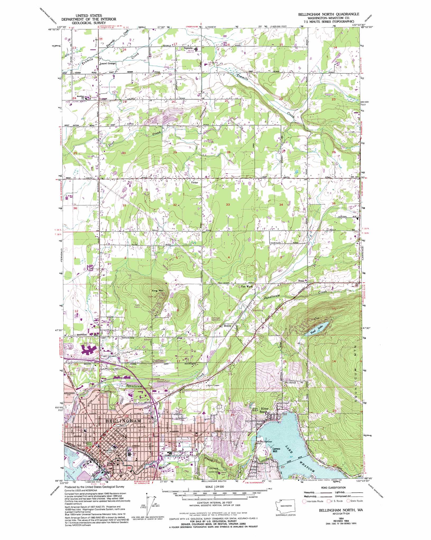
USGS Topo Quad 48122g4 - 1:24,000 scale
| Topo Map Name: | Bellingham North |
| USGS Topo Quad ID: | 48122g4 |
| Print Size: | ca. 21 1/4" wide x 27" high |
| Southeast Coordinates: | 48.75° N latitude / 122.375° W longitude |
| Map Center Coordinates: | 48.8125° N latitude / 122.4375° W longitude |
| U.S. State: | WA |
| Filename: | o48122g4.jpg |
| Download Map JPG Image: | Bellingham North topo map 1:24,000 scale |
| Map Type: | Topographic |
| Topo Series: | 7.5´ |
| Map Scale: | 1:24,000 |
| Source of Map Images: | United States Geological Survey (USGS) |
| Alternate Map Versions: |
Bellingham North WA 1954, updated 1957 Download PDF Buy paper map Bellingham North WA 1954, updated 1970 Download PDF Buy paper map Bellingham North WA 1954, updated 1974 Download PDF Buy paper map Bellingham North WA 1954, updated 1982 Download PDF Buy paper map Bellingham North WA 1954, updated 1994 Download PDF Buy paper map Bellingham North WA 2011 Download PDF Buy paper map Bellingham North WA 2014 Download PDF Buy paper map |
1:24,000 Topo Quads surrounding Bellingham North
Blaine |
Bertrand Creek |
Lynden |
Sumas |
Kendall |
Lummi Bay |
Ferndale |
Bellingham North |
Lawrence |
Deming |
Lummi Island |
Eliza Island |
Bellingham South |
Lake Whatcom |
Acme |
Cypress Island |
Anacortes North |
Bow |
Alger |
Sedro-Woolley North |
> Back to 48122e1 at 1:100,000 scale
> Back to 48122a1 at 1:250,000 scale
> Back to U.S. Topo Maps home
Bellingham North topo map: Gazetteer
Bellingham North: Airports
Saint Joseph Hospital Campus Heliport elevation 44m 144′Bellingham North: Channels
I and J Street Waterway elevation 3m 9′I and J Street Waterway elevation 4m 13′
Bellingham North: Crossings
Iowa Street Interchange elevation 14m 45′Meridian Street Interchange elevation 32m 104′
Sunset Street Interchange elevation 52m 170′
Bellingham North: Dams
Heavens-Lass Lagoon Dam elevation 65m 213′Whatcom Lake Dam elevation 98m 321′
Bellingham North: Lakes
Lake Whatcom elevation 98m 321′Sunset Pond elevation 31m 101′
Toad Lake elevation 219m 718′
Bellingham North: Parks
Battersby Field elevation 21m 68′Bloede Donovan Park elevation 99m 324′
Broadway Park elevation 32m 104′
Elizabeth Park elevation 21m 68′
Roosevelt Field elevation 25m 82′
Saint Clair Park elevation 64m 209′
Whatcom Falls Park elevation 94m 308′
Bellingham North: Populated Places
Alabama Hill elevation 67m 219′Bellingham elevation 21m 68′
Dewey elevation 51m 167′
Eureka elevation 33m 108′
Forest Ridge elevation 127m 416′
Larson Mill elevation 103m 337′
Laurel elevation 29m 95′
Noon elevation 102m 334′
Parkview elevation 35m 114′
Roosevelt elevation 19m 62′
Silver Beach elevation 112m 367′
Van Wyck elevation 62m 203′
Victor elevation 86m 282′
Washington Colony (historical) elevation 9m 29′
Bellingham North: Reservoirs
Heavens-Lass Lagoon elevation 65m 213′Heron Pond elevation 28m 91′
Lake Whatcom elevation 98m 321′
Bellingham North: Streams
Baker Creek elevation 26m 85′Fourmile Creek elevation 19m 62′
Spring Creek elevation 37m 121′
Toad Creek elevation 48m 157′
Whatcom Creek elevation 2m 6′
Bellingham North: Summits
King Mountain elevation 168m 551′Toad Mountain elevation 318m 1043′
Bellingham North digital topo map on disk
Buy this Bellingham North topo map showing relief, roads, GPS coordinates and other geographical features, as a high-resolution digital map file on DVD: