Port Angeles Topo Map Washington
To zoom in, hover over the map of Port Angeles
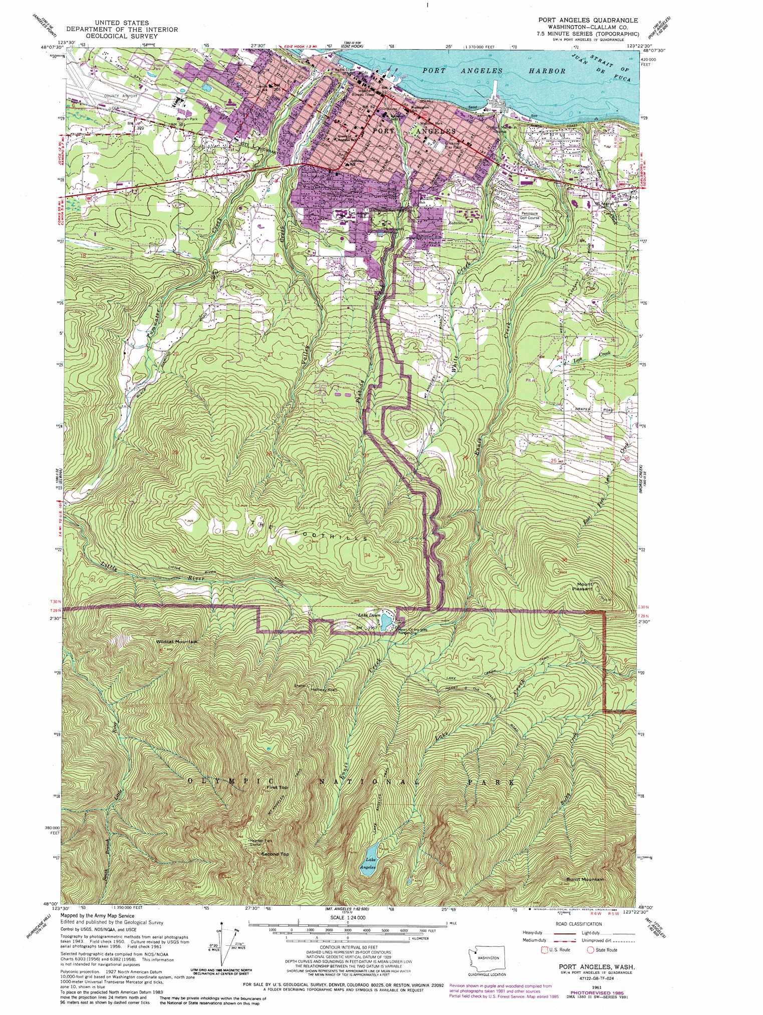
USGS Topo Quad 48123a4 - 1:24,000 scale
| Topo Map Name: | Port Angeles |
| USGS Topo Quad ID: | 48123a4 |
| Print Size: | ca. 21 1/4" wide x 27" high |
| Southeast Coordinates: | 48° N latitude / 123.375° W longitude |
| Map Center Coordinates: | 48.0625° N latitude / 123.4375° W longitude |
| U.S. State: | WA |
| Filename: | o48123a4.jpg |
| Download Map JPG Image: | Port Angeles topo map 1:24,000 scale |
| Map Type: | Topographic |
| Topo Series: | 7.5´ |
| Map Scale: | 1:24,000 |
| Source of Map Images: | United States Geological Survey (USGS) |
| Alternate Map Versions: |
Port Angeles WA 1950, updated 1955 Download PDF Buy paper map Port Angeles WA 1961, updated 1961 Download PDF Buy paper map Port Angeles WA 1961, updated 1979 Download PDF Buy paper map Port Angeles WA 1961, updated 1986 Download PDF Buy paper map Port Angeles WA 2011 Download PDF Buy paper map Port Angeles WA 2014 Download PDF Buy paper map |
| FStopo: | US Forest Service topo Port Angeles is available: Download FStopo PDF Download FStopo TIF |
1:24,000 Topo Quads surrounding Port Angeles
Joyce |
Angeles Point |
Ediz Hook |
||
Lake Sutherland |
Elwha |
Port Angeles |
Morse Creek |
Carlsborg |
Mount Carrie |
Hurricane Hill |
Mount Angeles |
Maiden Peak |
Tyler Peak |
Mount Olympus |
Mount Queets |
Mccartney Peak |
Wellesley Peak |
Mount Deception |
> Back to 48123a1 at 1:100,000 scale
> Back to 48122a1 at 1:250,000 scale
> Back to U.S. Topo Maps home
Port Angeles topo map: Gazetteer
Port Angeles: Airports
Clallam County Airport elevation 82m 269′Eclipse Heliport elevation 177m 580′
Lawson Airpark elevation 196m 643′
William R Fairchild International Airport elevation 82m 269′
Port Angeles: Bays
Port Angeles Harbor elevation 1m 3′Port Angeles: Dams
Black Diamond Reservoir Dam elevation 126m 413′Lake Dawn Dam elevation 551m 1807′
Peabody Heights Reservoir Dam elevation 122m 400′
Port Angeles: Lakes
Lake Angeles elevation 1289m 4229′Lake Dawn elevation 551m 1807′
Port Angeles: Parks
Erickson Play Field elevation 35m 114′Lincoln Park elevation 85m 278′
Webster Park elevation 31m 101′
Port Angeles: Populated Places
Port Angeles elevation 22m 72′Port Angeles: Ranges
The Foothills elevation 751m 2463′Port Angeles: Reservoirs
Black Diamond Reservoir elevation 126m 413′Lake Dawn elevation 551m 1807′
Peabody Heights Reservoir elevation 122m 400′
Port Angeles Reservoir elevation 123m 403′
Port Angeles: Streams
Cowen Creek elevation 348m 1141′East Fork Lees Creek elevation 90m 295′
Ennis Creek elevation 3m 9′
Lees Creek elevation 3m 9′
Peabody Creek elevation 11m 36′
Tumwater Creek elevation 4m 13′
Valley Creek elevation 0m 0′
White Creek elevation 3m 9′
Port Angeles: Summits
Burnt Mountain elevation 1498m 4914′First Top elevation 1682m 5518′
Halfway Rock elevation 867m 2844′
Mount Pleasant elevation 797m 2614′
Second Top elevation 1828m 5997′
Wildcat Mountain elevation 947m 3106′
Port Angeles: Trails
Lake Creek Trail elevation 531m 1742′Port Angeles digital topo map on disk
Buy this Port Angeles topo map showing relief, roads, GPS coordinates and other geographical features, as a high-resolution digital map file on DVD: