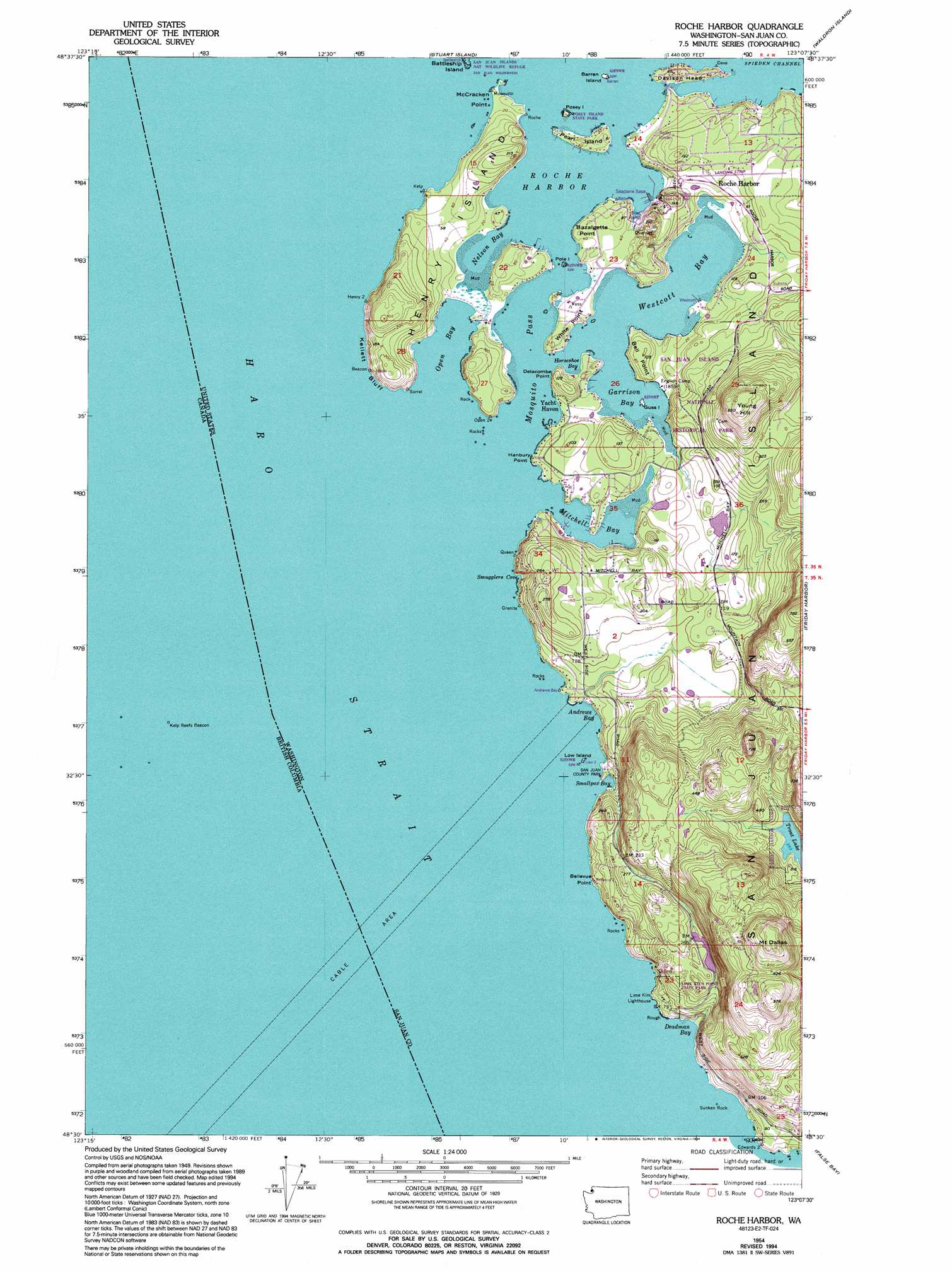
Roche Harbor Topo Map Washington
To zoom in, hover over the map of Roche Harbor
USGS Topo Quad 48123e2 - 1:24,000 scale
| Topo Map Name: | Roche Harbor |
| USGS Topo Quad ID: | 48123e2 |
| Print Size: | ca. 21 1/4" wide x 27" high |
| Southeast Coordinates: | 48.5° N latitude / 123.125° W longitude |
| Map Center Coordinates: | 48.5625° N latitude / 123.1875° W longitude |
| U.S. State: | WA |
| Filename: | o48123e2.jpg |
| Download Map JPG Image: | Roche Harbor topo map 1:24,000 scale |
| Map Type: | Topographic |
| Topo Series: | 7.5´ |
| Map Scale: | 1:24,000 |
| Source of Map Images: | United States Geological Survey (USGS) |
| Alternate Map Versions: |
Roche Harbor WA 1954, updated 1957 Download PDF Buy paper map Roche Harbor WA 1954, updated 1962 Download PDF Buy paper map Roche Harbor WA 1954, updated 1981 Download PDF Buy paper map Roche Harbor WA 1954, updated 1994 Download PDF Buy paper map Roche Harbor WA 2011 Download PDF Buy paper map Roche Harbor WA 2014 Download PDF Buy paper map |
1:24,000 Topo Quads surrounding Roche Harbor
Sucia Island |
||||
Stuart Island |
Waldron Island |
Eastsound |
||
Roche Harbor |
Friday Harbor |
Shaw Island |
||
False Bay |
Richardson |
|||
> Back to 48123e1 at 1:100,000 scale
> Back to 48122a1 at 1:250,000 scale
> Back to U.S. Topo Maps home
Roche Harbor topo map: Gazetteer
Roche Harbor: Airports
Roche Harbor Airport elevation 38m 124′Roche Harbor Seaplane Base elevation 8m 26′
Roche Harbor: Areas
Friday Harbor Watershed elevation 78m 255′Roche Harbor: Bays
Andrews Bay elevation 0m 0′Deadman Bay elevation 0m 0′
Garrison Bay elevation 0m 0′
Horseshoe Bay elevation 0m 0′
Mitchell Bay elevation 0m 0′
Mosquito Bay elevation 0m 0′
Nelson Bay elevation 0m 0′
Open Bay elevation 0m 0′
Roche Harbor elevation 0m 0′
Smallpox Bay elevation 12m 39′
Smugglers Cove elevation 1m 3′
Westcott Bay elevation 0m 0′
Roche Harbor: Capes
Bazalgette Point elevation 7m 22′Bell Point elevation 7m 22′
Bellevue Point elevation 19m 62′
Davison Head elevation 13m 42′
Delacombe Point elevation 34m 111′
Hanbury Point elevation 4m 13′
McCracken Point elevation 4m 13′
Sunset Point elevation 0m 0′
White Point elevation 12m 39′
Roche Harbor: Channels
Mosquito Pass elevation 0m 0′Roche Harbor: Cliffs
Kellett Bluff elevation 11m 36′Roche Harbor: Dams
Lawson Dam Number Two elevation 142m 465′Roache Habor Lake Dam elevation 74m 242′
Sams Dam elevation 71m 232′
Roche Harbor: Islands
Barren Island elevation 0m 0′Battleship Island elevation 10m 32′
Guss Island elevation 13m 42′
Henry Island elevation 13m 42′
Low Island elevation 8m 26′
Pearl Island elevation 14m 45′
Pole elevation 0m 0′
Posey elevation 7m 22′
Posey Island elevation 7m 22′
Sunken Rock elevation 0m 0′
Roche Harbor: Parks
Lime Kiln Point State Park elevation 57m 187′Posey Island State Park elevation 7m 22′
San Juan Park elevation 10m 32′
Roche Harbor: Populated Places
Roche Harbor elevation 19m 62′Yacht Haven elevation 8m 26′
Roche Harbor: Reservoirs
Carefree Lake elevation 71m 232′Roche Harbor Lake elevation 74m 242′
Roche Harbor: Summits
Mount Dallas elevation 331m 1085′Young Hill elevation 197m 646′
Roche Harbor digital topo map on disk
Buy this Roche Harbor topo map showing relief, roads, GPS coordinates and other geographical features, as a high-resolution digital map file on DVD: