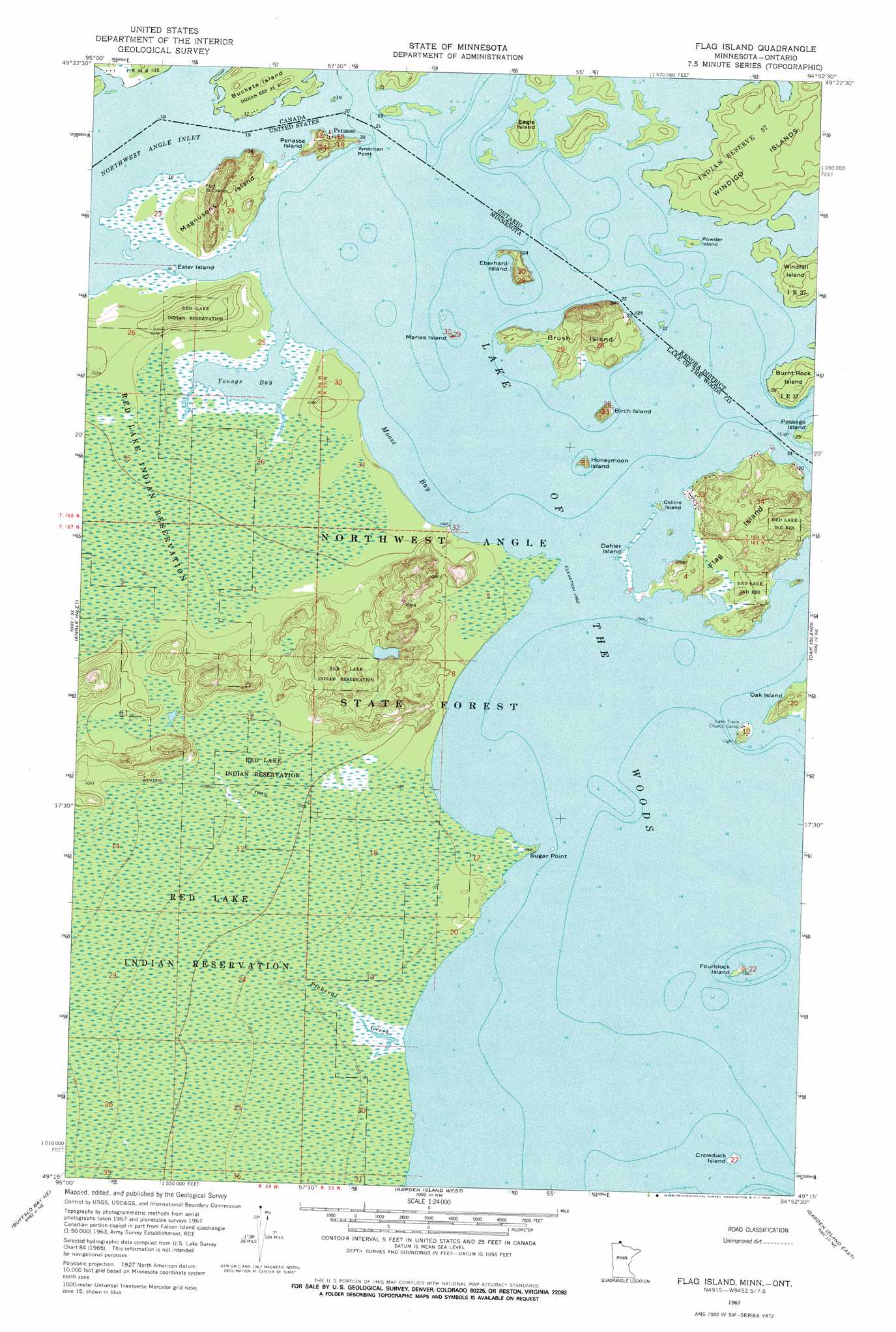
Flag Island Topo Map Minnesota
To zoom in, hover over the map of Flag Island
USGS Topo Quad 49094c8 - 1:24,000 scale
| Topo Map Name: | Flag Island |
| USGS Topo Quad ID: | 49094c8 |
| Print Size: | ca. 21 1/4" wide x 27" high |
| Southeast Coordinates: | 49.25° N latitude / 94.875° W longitude |
| Map Center Coordinates: | 49.3125° N latitude / 94.9375° W longitude |
| U.S. State: | MN |
| Filename: | o49094c8.jpg |
| Download Map JPG Image: | Flag Island topo map 1:24,000 scale |
| Map Type: | Topographic |
| Topo Series: | 7.5´ |
| Map Scale: | 1:24,000 |
| Source of Map Images: | United States Geological Survey (USGS) |
| Alternate Map Versions: |
Flag Island MN 1967, updated 1969 Download PDF Buy paper map Flag Island MN 2011 Download PDF Buy paper map Flag Island MN 2013 Download PDF Buy paper map Flag Island MN 2016 Download PDF Buy paper map |
1:24,000 Topo Quads surrounding Flag Island
Angle Inlet Sw |
Angle Inlet |
Flag Island |
Oak Island |
|
Buffalo Bay Nw |
Buffalo Bay Ne |
Garden Island West |
Garden Island East |
|
> Back to 49094a1 at 1:100,000 scale
> Back to 49094a1 at 1:250,000 scale
> Back to U.S. Topo Maps home
Flag Island topo map: Gazetteer
Flag Island: Bars
Flag Island Reef elevation 324m 1062′Flag Island: Bays
Moose Bay elevation 324m 1062′Youngs Bay elevation 324m 1062′
Flag Island: Capes
American Point elevation 324m 1062′Sugar Point elevation 324m 1062′
Flag Island: Forests
Northwest Angle State Forest elevation 330m 1082′Flag Island: Islands
Birch Island elevation 329m 1079′Brush Island elevation 332m 1089′
Collins Island elevation 324m 1062′
Crowduck Island elevation 324m 1062′
Dahler Island elevation 324m 1062′
Ester Island elevation 324m 1062′
Flag Island elevation 333m 1092′
Fourblock Island elevation 325m 1066′
Honeymoon Island elevation 327m 1072′
Lambert Island elevation 329m 1079′
Magnusons Island elevation 328m 1076′
Maries Island elevation 324m 1062′
Penasse Island elevation 332m 1089′
Flag Island: Parks
Pierre Gaultier De Varennes-Sieur De La Verendrye Historical Marker elevation 326m 1069′Flag Island: Populated Places
Fort Saint Charles elevation 326m 1069′Penasse elevation 325m 1066′
Flag Island: Post Offices
Penasse Post Office (historical) elevation 324m 1062′Sugar Point Post Office (historical) elevation 324m 1062′
Sugar Point Post Office (historical) elevation 324m 1062′
Flag Island: Streams
Pickeral Creek elevation 324m 1062′Flag Island digital topo map on disk
Buy this Flag Island topo map showing relief, roads, GPS coordinates and other geographical features, as a high-resolution digital map file on DVD: