Orlando Topo Map Florida
To zoom in, hover over the map of Orlando
USGS Topo Map 28081e1 - 1:100,000 scale
| Topo Map Name: | Orlando |
| USGS Topo Quad ID: | 28081e1 |
| Print Size: | ca. 39" wide x 24" high |
| Southeast Coordinates: | 28.5° N latitude / 81° W longitude |
| Map Center Coordinates: | 28.75° N latitude / 81.5° W longitude |
| U.S. State: | FL |
| Filename: | 28081e1.jpg |
| Download Map JPG Image: | Orlando topo map 1:100,000 scale |
| Map Type: | Topographic |
| Topo Series: | 30´x60´ |
| Map Scale: | 1:100,000 |
| Source of Map Images: | United States Geological Survey (USGS) |
| Alternate Map Versions: |
Orlando FL 1979, updated 1980 Download PDF Buy paper map Orlando FL 1979, updated 1992 Download PDF Buy paper map Orlando FL 1979, updated 1992 Download PDF Buy paper map |
1:100,000 Topos surrounding Orlando
Ocala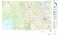 |
Daytona Beach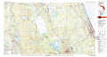 |
New Smyrna Beach |
Inverness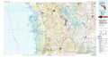 |
Orlando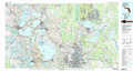 |
Titusville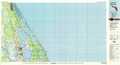 |
Tarpon Springs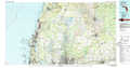 |
Kissimmee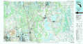 |
Cape Canaveral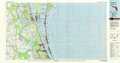 |
> Back to 28080a1 at 1:250,000 scale
> Back to U.S. Topo Maps home
1:24,000 Topo Quads covered by the spatial extent of this 100k map (Orlando)
|
Lady Lake 
|
Emeralda Island 
|
Umatilla 
|
Paisley 
|
Pine Lakes 
|
Orange City 
|
Lake Helen 
|
Lake Ashby 
|
|
Leesburg West 
|
Leesburg East 
|
Eustis 
|
Sorrento 
|
Sanford Sw 
|
Sanford 
|
Osteen 
|
Osceola 
|
|
Center Hill 
|
Hewey In The Hills 
|
Astatula 
|
Apopka 
|
Forest City 
|
Casselberry 
|
Oviedo 
|
Geneva 
|
|
Mascotte 
|
Clermont West 
|
Clermont East 
|
Winter Garden 
|
Orlando West 
|
Orlando East 
|
Oviedo Sw 
|
Bithlo 
|
