Boquillas Topo Map Texas
To zoom in, hover over the map of Boquillas
USGS Topo Map 29102a1 - 1:100,000 scale
| Topo Map Name: | Boquillas |
| USGS Topo Quad ID: | 29102a1 |
| Print Size: | ca. 39" wide x 24" high |
| Southeast Coordinates: | 29° N latitude / 102° W longitude |
| Map Center Coordinates: | 29.25° N latitude / 102.5° W longitude |
| U.S. State: | TX |
| Filename: | 29102a1.jpg |
| Download Map JPG Image: | Boquillas topo map 1:100,000 scale |
| Map Type: | Topographic |
| Topo Series: | 30´x60´ |
| Map Scale: | 1:100,000 |
| Source of Map Images: | United States Geological Survey (USGS) |
| Alternate Map Versions: |
Boquillas TX 1984, updated 1985 Download PDF Buy paper map Boquillas TX 1984, updated 1993 Download PDF Buy paper map |
1:100,000 Topos surrounding Boquillas
Santiago Mountains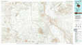 |
Dove Mountain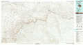 |
Comstock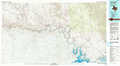 |
Chisos Mountains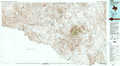 |
Boquillas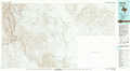 |
Amistead Village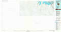 |
Mariscal Canyon |
> Back to 29102a1 at 1:250,000 scale
> Back to U.S. Topo Maps home
1:24,000 Topo Quads covered by the spatial extent of this 100k map (Boquillas)
|
Sue Peaks 
|
Stillwell Crossing 
|
||||||
|
Ernst Valley 
|
|||||||
|
Boquillas 
|
|||||||
