Camden Topo Map Arkansas
To zoom in, hover over the map of Camden
USGS Topo Map 33092e1 - 1:100,000 scale
| Topo Map Name: | Camden |
| USGS Topo Quad ID: | 33092e1 |
| Print Size: | ca. 39" wide x 24" high |
| Southeast Coordinates: | 33.5° N latitude / 92° W longitude |
| Map Center Coordinates: | 33.75° N latitude / 92.5° W longitude |
| U.S. State: | AR |
| Filename: | 33092e1.jpg |
| Download Map JPG Image: | Camden topo map 1:100,000 scale |
| Map Type: | Topographic |
| Topo Series: | 30´x60´ |
| Map Scale: | 1:100,000 |
| Source of Map Images: | United States Geological Survey (USGS) |
| Alternate Map Versions: |
Camden AR 1986, updated 1986 Download PDF Buy paper map |
1:100,000 Topos surrounding Camden
Arkadelphia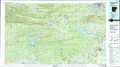 |
Malvern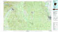 |
De Witt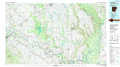 |
Hope |
Camden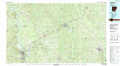 |
Dumas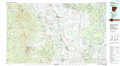 |
Magnolia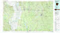 |
El Dorado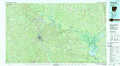 |
Crossett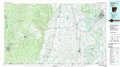 |
> Back to 33092a1 at 1:250,000 scale
> Back to U.S. Topo Maps home
1:24,000 Topo Quads covered by the spatial extent of this 100k map (Camden)
|
Sparkman Nw 
|
Sparkman 
|
Princeton West 
|
Princeton East 
|
Ivan 
|
Fordyce Ne 
|
Rison 
|
Calmer 
|
|
Tates Bluff 
|
Ouachita 
|
Holly Springs 
|
Hopeville 
|
Fordyce 
|
Kingsland 
|
New Edinburg 
|
Herbine 
|
|
Bragg City 
|
Harmony Grove 
|
Eagle Mills 
|
Bearden 
|
Chambersville 
|
Tinsman 
|
Mckinney 
|
Warren Ne 
|
|
Camden Sw 
|
Camden 
|
East Camden 
|
Woodberry 
|
Hampton 
|
Banks 
|
Farmville 
|
Warren 
|
