Tullahoma Topo Map Tennessee
To zoom in, hover over the map of Tullahoma
USGS Topo Map 35086a1 - 1:100,000 scale
| Topo Map Name: | Tullahoma |
| USGS Topo Quad ID: | 35086a1 |
| Print Size: | ca. 39" wide x 24" high |
| Southeast Coordinates: | 35° N latitude / 86° W longitude |
| Map Center Coordinates: | 35.25° N latitude / 86.5° W longitude |
| U.S. State: | TN |
| Filename: | 35086a1.jpg |
| Download Map JPG Image: | Tullahoma topo map 1:100,000 scale |
| Map Type: | Topographic |
| Topo Series: | 30´x60´ |
| Map Scale: | 1:100,000 |
| Source of Map Images: | United States Geological Survey (USGS) |
| Alternate Map Versions: |
Tullahoma TN 1981, updated 1982 Download PDF Buy paper map |
1:100,000 Topos surrounding Tullahoma
Hohenwald |
Murfreesboro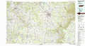 |
Mc Minnville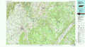 |
Lawrenceburg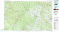 |
Tullahoma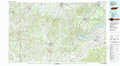 |
Chattanooga |
Tuscumbia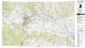 |
Huntsville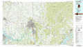 |
Chickamauga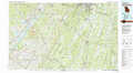 |
> Back to 35086a1 at 1:250,000 scale
> Back to U.S. Topo Maps home
1:24,000 Topo Quads covered by the spatial extent of this 100k map (Tullahoma)
|
Campbells Station 
|
Lewisburg 
|
Belfast 
|
Bedford 
|
Shelbyville 
|
Normandy 
|
Normandy Lake 
|
Manchester 
|
|
Brick Church 
|
Cornersville 
|
Petersburg 
|
Belleville 
|
Lynchburg West 
|
Lynchburg East 
|
Tullahoma 
|
Capitol Hill 
|
|
Tarpley 
|
Frankewing 
|
Boonshill 
|
Fayetteville 
|
Mulberry 
|
Lois 
|
Belvidere 
|
Winchester 
|
|
Elkton 
|
Dellrose 
|
Taft 
|
Lincoln 
|
Flintville 
|
Huntland 
|
Beans Creek 
|
Pitcher Ridge 
|
