Delano Topo Map California
To zoom in, hover over the map of Delano
USGS Topo Map 35119e1 - 1:100,000 scale
| Topo Map Name: | Delano |
| USGS Topo Quad ID: | 35119e1 |
| Print Size: | ca. 39" wide x 24" high |
| Southeast Coordinates: | 35.5° N latitude / 119° W longitude |
| Map Center Coordinates: | 35.75° N latitude / 119.5° W longitude |
| U.S. State: | CA |
| Filename: | 35119e1.jpg |
| Download Map JPG Image: | Delano topo map 1:100,000 scale |
| Map Type: | Topographic |
| Topo Series: | 30´x60´ |
| Map Scale: | 1:100,000 |
| Source of Map Images: | United States Geological Survey (USGS) |
| Alternate Map Versions: |
Delano CA 1993, updated 1993 Download PDF Buy paper map Delano CA 1993, updated 1993 Download PDF Buy paper map |
1:100,000 Topos surrounding Delano
Coalinga |
Visalia |
Three Rivers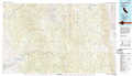 |
Paso Robles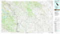 |
Delano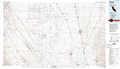 |
Isabella Lake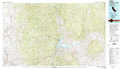 |
San Luis Obispo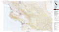 |
Taft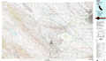 |
Tehachapi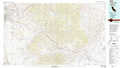 |
> Back to 35118a1 at 1:250,000 scale
> Back to U.S. Topo Maps home
1:24,000 Topo Quads covered by the spatial extent of this 100k map (Delano)
|
Los Viejos 
|
Dudley Ridge 
|
Hacienda Ranch Nw 
|
Hacienda Ranch Ne 
|
Alpaugh 
|
Pixley 
|
Sausalito School 
|
Ducor 
|
|
Avenal Gap 
|
West Camp 
|
Lone Tree Well 
|
Hacienda Ranch 
|
Allensworth 
|
Delano West 
|
Delano East 
|
Richgrove 
|
|
Emigrant Hill 
|
Antelope Plain 
|
Lost Hills Nw 
|
Lost Hills Ne 
|
Wasco Nw 
|
Pond 
|
Mcfarland 
|
Deepwell Ranch 
|
|
Shale Point 
|
Blackwells Corner 
|
Lost Hills 
|
Semitropic 
|
Wasco Sw 
|
Wasco 
|
Famoso 
|
North Of Oildale 
|
