Cambria Topo Map California
To zoom in, hover over the map of Cambria
USGS Topo Map 35121e1 - 1:100,000 scale
| Topo Map Name: | Cambria |
| USGS Topo Quad ID: | 35121e1 |
| Print Size: | ca. 39" wide x 24" high |
| Southeast Coordinates: | 35.5° N latitude / 121° W longitude |
| Map Center Coordinates: | 35.75° N latitude / 121.5° W longitude |
| U.S. State: | CA |
| Filename: | 35121e1.jpg |
| Download Map JPG Image: | Cambria topo map 1:100,000 scale |
| Map Type: | Topographic |
| Topo Series: | 30´x60´ |
| Map Scale: | 1:100,000 |
| Source of Map Images: | United States Geological Survey (USGS) |
| Alternate Map Versions: |
Cambria CA 1980, updated 1980 Download PDF Buy paper map Cambria CA 1980, updated 1987 Download PDF Buy paper map |
1:100,000 Topos surrounding Cambria
Point Sur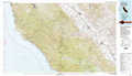 |
Coalinga |
|
Cambria |
Paso Robles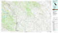 |
|
Point Estero |
San Luis Obispo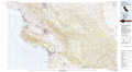 |
> Back to 35120a1 at 1:250,000 scale
> Back to U.S. Topo Maps home
1:24,000 Topo Quads covered by the spatial extent of this 100k map (Cambria)
|
Cape San Martin 
|
Alder Peak 
|
Jolon 
|
Williams Hill 
|
||||
|
Villa Creek 
|
Burro Mountain 
|
Burnett Peak 
|
Bryson 
|
||||
|
Piedras Blancas 
|
San Simeon 
|
Pebblestone Shut-In 
|
|||||
|
Pico Creek 
|
Cambria 
|
