Beckley Topo Map West Virginia
To zoom in, hover over the map of Beckley
USGS Topo Map 37081e1 - 1:100,000 scale
| Topo Map Name: | Beckley |
| USGS Topo Quad ID: | 37081e1 |
| Print Size: | ca. 39" wide x 24" high |
| Southeast Coordinates: | 37.5° N latitude / 81° W longitude |
| Map Center Coordinates: | 37.75° N latitude / 81.5° W longitude |
| U.S. States: | WV, VA, KY |
| Filename: | 37081e1.jpg |
| Download Map JPG Image: | Beckley topo map 1:100,000 scale |
| Map Type: | Topographic |
| Topo Series: | 30´x60´ |
| Map Scale: | 1:100,000 |
| Source of Map Images: | United States Geological Survey (USGS) |
| Alternate Map Versions: |
Beckley WV 1982, updated 1984 Download PDF Buy paper map |
1:100,000 Topos surrounding Beckley
Huntington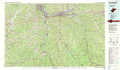 |
Charleston |
Marlinton |
Williamson |
Beckley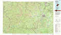 |
Lewisburg |
Pikeville |
Bluefield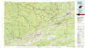 |
Radford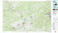 |
> Back to 37080a1 at 1:250,000 scale
> Back to U.S. Topo Maps home
1:24,000 Topo Quads covered by the spatial extent of this 100k map (Beckley)
|
Henlawson 
|
Clothier 
|
Wharton 
|
Whitesville 
|
Dorothy 
|
Pax 
|
Oak Hill 
|
Thurmond 
|
|
Logan 
|
Amherstdale 
|
Lorado 
|
Pilot Knob 
|
Arnett 
|
Eccles 
|
Beckley 
|
Prince 
|
|
Man 
|
Mallory 
|
Oceana 
|
Matheny 
|
Mcgraws 
|
Lester 
|
Crab Orchard 
|
Shady Spring 
|
|
Wharncliffe 
|
Gilbert 
|
Baileysville 
|
Pineville 
|
Mullens 
|
Rhodell 
|
Odd 
|
Flat Top 
|
