Somerset Topo Map Kentucky
To zoom in, hover over the map of Somerset
USGS Topo Map 37084a1 - 1:100,000 scale
| Topo Map Name: | Somerset |
| USGS Topo Quad ID: | 37084a1 |
| Print Size: | ca. 39" wide x 24" high |
| Southeast Coordinates: | 37° N latitude / 84° W longitude |
| Map Center Coordinates: | 37.25° N latitude / 84.5° W longitude |
| U.S. State: | KY |
| Filename: | 37084a1.jpg |
| Download Map JPG Image: | Somerset topo map 1:100,000 scale |
| Map Type: | Topographic |
| Topo Series: | 30´x60´ |
| Map Scale: | 1:100,000 |
| Source of Map Images: | United States Geological Survey (USGS) |
| Alternate Map Versions: |
Somerset KY 1982, updated 1983 Download PDF Buy paper map |
1:100,000 Topos surrounding Somerset
Elizabethtown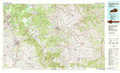 |
Harrodsburg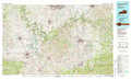 |
Irvine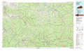 |
Campbellsville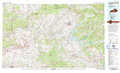 |
Somerset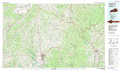 |
Hazard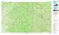 |
Tompkinsville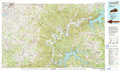 |
Corbin |
Middlesboro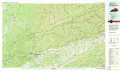 |
> Back to 37084a1 at 1:250,000 scale
> Back to U.S. Topo Maps home
1:24,000 Topo Quads covered by the spatial extent of this 100k map (Somerset)
|
Ellisburg 
|
Hustonville 
|
Halls Gap 
|
Crab Orchard 
|
Brodhead 
|
Wildie 
|
Johnetta 
|
Sandgap 
|
|
Liberty 
|
Yosemite 
|
Eubank 
|
Woodstock 
|
Maretburg 
|
Mount Vernon 
|
Livingston 
|
Parrot 
|
|
Phil 
|
Mintonville 
|
Science Hill 
|
Bobtown 
|
Shopville 
|
Billows 
|
Bernstadt 
|
London 
|
|
Eli 
|
Faubush 
|
Delmer 
|
Somerset 
|
Dykes 
|
Ano 
|
London Sw 
|
Lily 
|
