Leonardtown Topo Map Maryland
To zoom in, hover over the map of Leonardtown
USGS Topo Map 38076a1 - 1:100,000 scale
| Topo Map Name: | Leonardtown |
| USGS Topo Quad ID: | 38076a1 |
| Print Size: | ca. 39" wide x 24" high |
| Southeast Coordinates: | 38° N latitude / 76° W longitude |
| Map Center Coordinates: | 38.25° N latitude / 76.5° W longitude |
| U.S. States: | MD, VA |
| Filename: | 38076a1.jpg |
| Download Map JPG Image: | Leonardtown topo map 1:100,000 scale |
| Map Type: | Topographic |
| Topo Series: | 30´x60´ |
| Map Scale: | 1:100,000 |
| Source of Map Images: | United States Geological Survey (USGS) |
| Alternate Map Versions: |
Leonardtown MD 1983, updated 1984 Download PDF Buy paper map Leonardtown MD 1983, updated 1984 Download PDF Buy paper map |
1:100,000 Topos surrounding Leonardtown
Washington West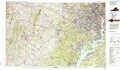 |
Washington East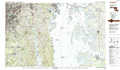 |
Seaford |
Fredericksburg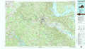 |
Leonardtown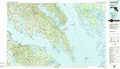 |
Salisbury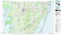 |
Richmond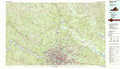 |
Tappahannock |
Chincoteague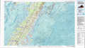 |
> Back to 38076a1 at 1:250,000 scale
> Back to U.S. Topo Maps home
1:24,000 Topo Quads covered by the spatial extent of this 100k map (Leonardtown)
|
Popes Creek 
|
Charlotte Hall 
|
Mechanicsville 
|
Broomes Island 
|
Cove Point 
|
Taylors Island 
|
Golden Hill 
|
Blackwater River 
|
|
Colonial Beach North 
|
Rock Point 
|
Leonardtown 
|
Hollywood 
|
Solomons Island 
|
Barren Island 
|
Honga 
|
Wingate 
|
|
Colonial Beach South 
|
Stratford Hall 
|
Saint Clements Island 
|
Piney Point 
|
Saint Marys City 
|
Point No Point 
|
Richland Point 
|
Bloodsworth Island 
|
|
Champlain 
|
Montross 
|
Machodoc 
|
Kinsale 
|
Saint George Island 
|
Point Lookout 
|
East Of Point Lookout 
|
Kedges Straits 
|
