Long Island East Topo Map New York
To zoom in, hover over the map of Long Island East
USGS Topo Map 40072e1 - 1:100,000 scale
| Topo Map Name: | Long Island East |
| USGS Topo Quad ID: | 40072e1 |
| Print Size: | ca. 39" wide x 24" high |
| Southeast Coordinates: | 40.5° N latitude / 72° W longitude |
| Map Center Coordinates: | 40.75° N latitude / 72.5° W longitude |
| U.S. State: | NY |
| Filename: | 40072e1.jpg |
| Download Map JPG Image: | Long Island East topo map 1:100,000 scale |
| Map Type: | Topographic |
| Topo Series: | 30´x60´ |
| Map Scale: | 1:100,000 |
| Source of Map Images: | United States Geological Survey (USGS) |
| Alternate Map Versions: |
Long Island East NY 1984, updated 1985 Download PDF Buy paper map Long Island East NY 1984, updated 1988 Download PDF Buy paper map Long Island East NY 1984, updated 1988 Download PDF Buy paper map |
1:100,000 Topos surrounding Long Island East
Bridgeport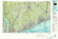 |
New Haven |
Block Island |
Long Island West |
Long Island East |
|
Long Branch |
> Back to 40072a1 at 1:250,000 scale
> Back to U.S. Topo Maps home
1:24,000 Topo Quads covered by the spatial extent of this 100k map (Long Island East)
|
Middle Island 
|
Wading River 
|
Riverhead 
|
Mattituck 
|
Southampton 
|
Sag Harbor 
|
East Hampton 
|
Napeague Beach 
|
|
Bellport 
|
Moriches 
|
Eastport 
|
Quogue 
|
Shinnecock Inlet 
|
|||
|
Howells Point 
|
Pattersquash Island 
|
||||||
