Long Island West Topo Map New York
To zoom in, hover over the map of Long Island West
USGS Topo Map 40073e1 - 1:100,000 scale
| Topo Map Name: | Long Island West |
| USGS Topo Quad ID: | 40073e1 |
| Print Size: | ca. 39" wide x 24" high |
| Southeast Coordinates: | 40.5° N latitude / 73° W longitude |
| Map Center Coordinates: | 40.75° N latitude / 73.5° W longitude |
| U.S. States: | NY, NJ, CT |
| Filename: | 40073e1.jpg |
| Download Map JPG Image: | Long Island West topo map 1:100,000 scale |
| Map Type: | Topographic |
| Topo Series: | 30´x60´ |
| Map Scale: | 1:100,000 |
| Source of Map Images: | United States Geological Survey (USGS) |
| Alternate Map Versions: |
Long Island West NY 1984, updated 1986 Download PDF Buy paper map Long Island West NY 1984, updated 1988 Download PDF Buy paper map |
1:100,000 Topos surrounding Long Island West
Middletown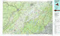 |
Bridgeport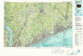 |
New Haven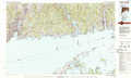 |
Newark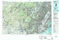 |
Long Island West |
Long Island East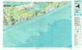 |
Trenton |
Long Branch |
> Back to 40072a1 at 1:250,000 scale
> Back to U.S. Topo Maps home
1:24,000 Topo Quads covered by the spatial extent of this 100k map (Long Island West)
|
Yonkers 
|
Mount Vernon 
|
Mamaroneck 
|
Bayville 
|
Lloyd Harbor 
|
Northport 
|
Saint James 
|
Port Jefferson 
|
|
Central Park 
|
Flushing 
|
Sea Cliff 
|
Hicksville 
|
Huntington 
|
Greenlawn 
|
Central Islip 
|
Patchogue 
|
|
Brooklyn 
|
Jamaica 
|
Lynbrook 
|
Freeport 
|
Amityville 
|
Bay Shore West 
|
Bay Shore East 
|
Sayville 
|
|
Coney Island 
|
Far Rockaway 
|
Lawrence 
|
Jones Inlet 
|
West Gilgo Beach 
|
