Williamsport East Topo Map Pennsylvania
To zoom in, hover over the map of Williamsport East
USGS Topo Map 41076a1 - 1:100,000 scale
| Topo Map Name: | Williamsport East |
| USGS Topo Quad ID: | 41076a1 |
| Print Size: | ca. 39" wide x 24" high |
| Southeast Coordinates: | 41° N latitude / 76° W longitude |
| Map Center Coordinates: | 41.25° N latitude / 76.5° W longitude |
| U.S. State: | PA |
| Filename: | 41076a1.jpg |
| Download Map JPG Image: | Williamsport East topo map 1:100,000 scale |
| Map Type: | Topographic |
| Topo Series: | 30´x60´ |
| Map Scale: | 1:100,000 |
| Source of Map Images: | United States Geological Survey (USGS) |
| Alternate Map Versions: |
Williamsport East PA 1984, updated 1985 Download PDF Buy paper map Williamsport East PA 1984, updated 1988 Download PDF Buy paper map |
1:100,000 Topos surrounding Williamsport East
Wellsboro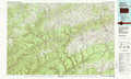 |
Towanda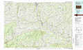 |
Honesdale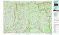 |
Williamsport West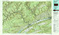 |
Williamsport East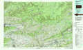 |
Scranton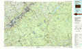 |
State College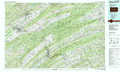 |
Sunbury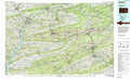 |
Allentown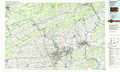 |
> Back to 41076a1 at 1:250,000 scale
> Back to U.S. Topo Maps home
1:24,000 Topo Quads covered by the spatial extent of this 100k map (Williamsport East)
|
Bodines 
|
Barbours 
|
Hillsgrove 
|
Eagles Mere 
|
Laporte 
|
Lopez 
|
Dutch Mountain 
|
Noxen 
|
|
Montoursville North 
|
Huntersville 
|
Picture Rocks 
|
Sonestown 
|
Elk Grove 
|
Red Rock 
|
Sweet Valley 
|
Harveys Lake 
|
|
Montoursville South 
|
Muncy 
|
Hughesville 
|
Lairdsville 
|
Benton 
|
Stillwater 
|
Shickshinny 
|
Nanticoke 
|
|
Allenwood 
|
Milton 
|
Washingtonville 
|
Millville 
|
Bloomsburg 
|
Mifflinville 
|
Berwick 
|
Sybertsville 
|
