Elkhart Topo Map Indiana
To zoom in, hover over the map of Elkhart
USGS Topo Map 41085e1 - 1:100,000 scale
| Topo Map Name: | Elkhart |
| USGS Topo Quad ID: | 41085e1 |
| Print Size: | ca. 39" wide x 24" high |
| Southeast Coordinates: | 41.5° N latitude / 85° W longitude |
| Map Center Coordinates: | 41.75° N latitude / 85.5° W longitude |
| U.S. States: | IN, MI |
| Filename: | 41085e1.jpg |
| Download Map JPG Image: | Elkhart topo map 1:100,000 scale |
| Map Type: | Topographic |
| Topo Series: | 30´x60´ |
| Map Scale: | 1:100,000 |
| Source of Map Images: | United States Geological Survey (USGS) |
| Alternate Map Versions: |
Elkhart IN 1985, updated 1985 Download PDF Buy paper map Elkhart IN 1985, updated 1991 Download PDF Buy paper map |
1:100,000 Topos surrounding Elkhart
Benton Harbor |
Kalamazoo |
Jackson |
South Bend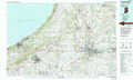 |
Elkhart |
Adrian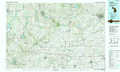 |
Knox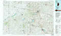 |
Fort Wayne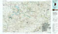 |
Defiance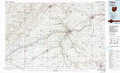 |
> Back to 41084a1 at 1:250,000 scale
> Back to U.S. Topo Maps home
1:24,000 Topo Quads covered by the spatial extent of this 100k map (Elkhart)
|
Vandalia 
|
Jones 
|
Three Rivers West 
|
Three Rivers East 
|
Nottawa 
|
Colon 
|
Bronson North 
|
Coldwater West 
|
|
Adamsville 
|
Mottville 
|
Constantine 
|
Klinger Lake 
|
Sturgis 
|
Burr Oak 
|
Bronson South 
|
Kinderhook 
|
|
Elkhart 
|
Bristol 
|
Middlebury 
|
Shipshewana 
|
Lagrange 
|
Mongo 
|
Orland 
|
Angola West 
|
|
Foraker 
|
Goshen 
|
Millersburg 
|
Topeka 
|
Oliver Lake 
|
Wolcottville 
|
Stroh 
|
Ashley 
|
