Chugwater Topo Map Wyoming
To zoom in, hover over the map of Chugwater
USGS Topo Map 41104e1 - 1:100,000 scale
| Topo Map Name: | Chugwater |
| USGS Topo Quad ID: | 41104e1 |
| Print Size: | ca. 39" wide x 24" high |
| Southeast Coordinates: | 41.5° N latitude / 104° W longitude |
| Map Center Coordinates: | 41.75° N latitude / 104.5° W longitude |
| U.S. States: | WY, NE |
| Filename: | 41104e1.jpg |
| Download Map JPG Image: | Chugwater topo map 1:100,000 scale |
| Map Type: | Topographic |
| Topo Series: | 30´x60´ |
| Map Scale: | 1:100,000 |
| Source of Map Images: | United States Geological Survey (USGS) |
| Alternate Map Versions: | none available in database |
1:100,000 Topos surrounding Chugwater
Laramie Peak |
Torrington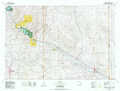 |
Hemingford |
Rock River |
Chugwater |
Scottsbluff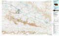 |
Laramie |
Cheyenne |
Kimball |
> Back to 41104a1 at 1:250,000 scale
> Back to U.S. Topo Maps home
1:24,000 Topo Quads covered by the spatial extent of this 100k map (Chugwater)
|
Ferguson Corner 
|
Bordeaux 
|
Dickinson Hill 
|
Glomill Reservoir 
|
Veteran 
|
Yoder 
|
Huntley 
|
Lyman 
|
|
Double L Ranch 
|
Chugwater 
|
Klutz Canyon 
|
Y B O Ranch 
|
Needle Rock 
|
Hawk Springs 
|
Duroc 
|
Robb Draw 
|
|
Whitcomb Hill 
|
Bristol Ridge Ne 
|
C S Ranch 
|
Cattail Ranch Ne 
|
Diamond Flat 
|
Kessler Gap 
|
La Grange 
|
Mccompsey Pass 
|
|
Bristol Ridge 
|
Moffett Ranch 
|
Indian Hill 
|
Cattail Ranch 
|
Rocky Hollow 
|
Meriden 
|
Petsch Reservoir 
|
Tremain 
|
