Powell Topo Map Wyoming
To zoom in, hover over the map of Powell
USGS Topo Map 44108e1 - 1:100,000 scale
| Topo Map Name: | Powell |
| USGS Topo Quad ID: | 44108e1 |
| Print Size: | ca. 39" wide x 24" high |
| Southeast Coordinates: | 44.5° N latitude / 108° W longitude |
| Map Center Coordinates: | 44.75° N latitude / 108.5° W longitude |
| U.S. State: | WY |
| Filename: | 44108e1.jpg |
| Download Map JPG Image: | Powell topo map 1:100,000 scale |
| Map Type: | Topographic |
| Topo Series: | 30´x60´ |
| Map Scale: | 1:100,000 |
| Source of Map Images: | United States Geological Survey (USGS) |
| Alternate Map Versions: |
Powell WY 1980, updated 1982 Download PDF Buy paper map |
1:100,000 Topos surrounding Powell
Red Lodge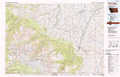 |
Bridger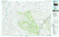 |
Lodge Grass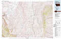 |
Cody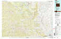 |
Powell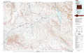 |
Burgess Junction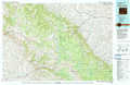 |
Carter Mountain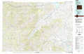 |
Basin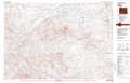 |
Worland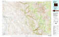 |
> Back to 44108a1 at 1:250,000 scale
> Back to U.S. Topo Maps home
1:24,000 Topo Quads covered by the spatial extent of this 100k map (Powell)
|
Elk Basin Nw 
|
Elk Basin 
|
Deaver Reservoir 
|
Frannie 
|
Cowley 
|
Sykes Spring 
|
Natural Trap Cave 
|
Simmons Canyon 
|
|
Elk Basin Sw 
|
Elk Basin Se 
|
Garland 
|
Byron 
|
Lovell 
|
Lovell Lakes 
|
Kane 
|
Cottonwood Canyon 
|
|
Vocation 
|
Ralston 
|
Gilmore Hill Nw 
|
Gilmore Hill Ne 
|
Jack Horner Reservoir 
|
North Emblem Reservoir 
|
Spence 
|
Alkali Creek 
|
|
Corbett Dam 
|
Stone Barn Camp 
|
Gilmore Hill 
|
Gilmore Hill Se 
|
Emblem 
|
Emblem Se 
|
Sheep Canyon 
|
Greybull North 
|
