Riggins Topo Map Idaho
To zoom in, hover over the map of Riggins
USGS Topo Map 45116a1 - 1:100,000 scale
| Topo Map Name: | Riggins |
| USGS Topo Quad ID: | 45116a1 |
| Print Size: | ca. 39" wide x 24" high |
| Southeast Coordinates: | 45° N latitude / 116° W longitude |
| Map Center Coordinates: | 45.25° N latitude / 116.5° W longitude |
| U.S. States: | ID, OR |
| Filename: | 45116a1.jpg |
| Download Map JPG Image: | Riggins topo map 1:100,000 scale |
| Map Type: | Topographic |
| Topo Series: | 30´x60´ |
| Map Scale: | 1:100,000 |
| Source of Map Images: | United States Geological Survey (USGS) |
| Alternate Map Versions: |
Riggins ID 1987, updated 1987 Download PDF Buy paper map |
1:100,000 Topos surrounding Riggins
Wallowa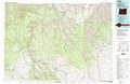 |
Grangeville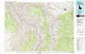 |
Elk City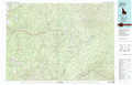 |
Enterprise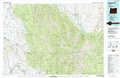 |
Riggins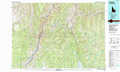 |
Warren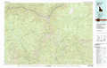 |
Baker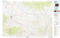 |
Mc Call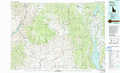 |
Pistol Creek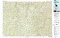 |
> Back to 45116a1 at 1:250,000 scale
> Back to U.S. Topo Maps home
1:24,000 Topo Quads covered by the spatial extent of this 100k map (Riggins)
|
Clear Lake Ridge 
|
Sheep Creek Divide 
|
Hat Point 
|
Old Time Mountain 
|
Kessler Creek 
|
Riggins 
|
Riggins Hot Springs 
|
Kelly Mountain 
|
|
Harl Butte 
|
Jaynes Ridge 
|
Squirrel Prairie 
|
He Devil 
|
Heavens Gate 
|
Pollock 
|
Patrick Butte 
|
Hershey Point 
|
|
Gumboot Butte 
|
Puderbaugh Ridge 
|
White Monument 
|
Purgatory Saddle 
|
Pollock Mountain 
|
Indian Mountain 
|
Hazard Lake 
|
Black Tip 
|
|
Duck Creek 
|
Homestead 
|
Cuprum 
|
Butterfield Gulch 
|
Railroad Saddle 
|
Bally Mountain 
|
Brundage Mountain 
|
Granite Lake 
|
