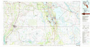
Ft Pierce Topo Map Florida
To zoom in, hover over the map of Ft Pierce
USGS Topo Map 27080a1 - 1:250,000 scale
| Topo Map Name: | Ft Pierce |
| USGS Topo Quad ID: | 27080a1 |
| Print Size: | ca. 32" wide x 22 1/2" high |
| Southeast Coordinates: | 27° N latitude / 80° W longitude |
| Map Center Coordinates: | 27.5° N latitude / 81° W longitude |
| U.S. State: | FL |
| Filename: | 27080a1.jpg |
| Download Map JPG Image: | Ft Pierce topo map 1:250,000 scale |
| Map Type: | Topographic |
| Topo Series: | 1°x2° |
| Map Scale: | 1:250,000 |
| Source of Map Images: | United States Geological Survey (USGS) |
| Alternate Map Versions: |
Fort Pierce FL 1956, updated 1965 Download PDF Buy paper map Fort Pierce FL 1956, updated 1974 Download PDF Buy paper map Fort Pierce FL 1956, updated 1976 Download PDF Buy paper map Fort Pierce FL 1956, updated 1984 Download PDF Buy paper map Fort Pierce FL 1959, updated 1959 Download PDF Buy paper map Fort Pierce FL 1959, updated 1959 Download PDF Buy paper map Fort Pierce FL 1988, updated 1988 Download PDF Buy paper map |
1:250,000 Topos surrounding Ft Pierce
Tarpon Springs / Plant City FL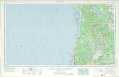 |
Orlando FL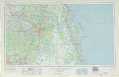 |
|
St Petersburg FL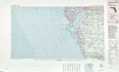 |
Ft Pierce FL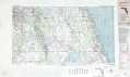 |
|
Charlotte Harbor FL |
West Palm Beach FL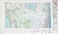 |
> Back to U.S. Topo Maps home
1:100,000 Topo Maps covered by the spatial extent of this 250k map (Ft Pierce)
Bartow FL |
Vero Beach FL |
Arcadia FL |
Fort Pierce FL |