Appalachicola Topo Map Florida
To zoom in, hover over the map of Appalachicola
USGS Topo Map 29084a1 - 1:250,000 scale
| Topo Map Name: | Appalachicola |
| USGS Topo Quad ID: | 29084a1 |
| Print Size: | ca. 32" wide x 22 1/2" high |
| Southeast Coordinates: | 29° N latitude / 84° W longitude |
| Map Center Coordinates: | 29.5° N latitude / 85° W longitude |
| U.S. State: | FL |
| Filename: | 29084a1.jpg |
| Download Map JPG Image: | Appalachicola topo map 1:250,000 scale |
| Map Type: | Topographic |
| Topo Series: | 1°x2° |
| Map Scale: | 1:250,000 |
| Source of Map Images: | United States Geological Survey (USGS) |
| Alternate Map Versions: |
Apalachicola FL 1949, updated 1949 Download PDF Buy paper map Apalachicola FL 1957, updated 1968 Download PDF Buy paper map Apalachicola FL 1957, updated 1976 Download PDF Buy paper map Apalachicola FL 1960, updated 1960 Download PDF Buy paper map Apalachicola FL 1967, updated 1975 Download PDF Buy paper map Apalachicola FL 1988, updated 1988 Download PDF Buy paper map |
1:250,000 Topos surrounding Appalachicola
Pensacola FL, AL |
Tallahassee FL, GA |
Valdosta FL, GA |
Appalachicola FL |
Gainesville FL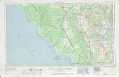 |
|
Tarpon Springs / Plant City FL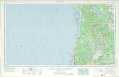 |
> Back to U.S. Topo Maps home
1:100,000 Topo Maps covered by the spatial extent of this 250k map (Appalachicola)
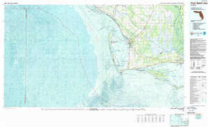
Port Saint Joe FL |
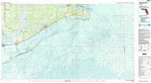
Carrabelle FL |