Hot Springs Topo Map South Dakota
To zoom in, hover over the map of Hot Springs
USGS Topo Map 43102a1 - 1:250,000 scale
| Topo Map Name: | Hot Springs |
| USGS Topo Quad ID: | 43102a1 |
| Print Size: | ca. 32" wide x 22 1/2" high |
| Southeast Coordinates: | 43° N latitude / 102° W longitude |
| Map Center Coordinates: | 43.5° N latitude / 103° W longitude |
| U.S. State: | SD |
| Filename: | 43102a1.jpg |
| Download Map JPG Image: | Hot Springs topo map 1:250,000 scale |
| Map Type: | Topographic |
| Topo Series: | 1°x2° |
| Map Scale: | 1:250,000 |
| Source of Map Images: | United States Geological Survey (USGS) |
| Alternate Map Versions: |
Hot Springs SD 1955, updated 1958 Download PDF Buy paper map Hot Springs SD 1955, updated 1964 Download PDF Buy paper map Hot Springs SD 1955, updated 1977 Download PDF Buy paper map Hot Springs SD 1955, updated 1978 Download PDF Buy paper map |
1:250,000 Topos surrounding Hot Springs
Gillette WY, SD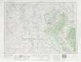 |
Rapid City SD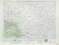 |
Pierre SD |
Newcastle WY, SD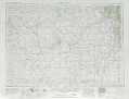 |
Hot Springs SD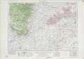 |
Martin SD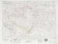 |
Torrington WY, NE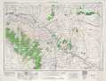 |
Alliance NE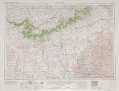 |
Valentine NE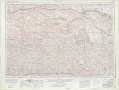 |
> Back to U.S. Topo Maps home
1:100,000 Topo Maps covered by the spatial extent of this 250k map (Hot Springs)
Mount Rushmore SD |
Wall SD |
Hot Springs SD, NE |
Pine Ridge SD, NE |


