Southeast coordinates of Hampton topo map
Interactive topo map of Southeast coordinates of Hampton, NH
| Place Name: | Southeast coordinates of Hampton |
| Feature Class: | Topo Map |
| Country: | United States |
| Latitude: | 42.875 |
| Longitude: | -70.75 |
| USGS Quad: | Hampton topo map |
| 7.5´ topo: | 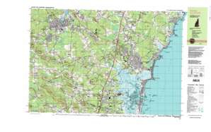 |
| State topo index: | NH topo index |
| Alternate map versions: | NH topographic maps Editions by year, direct download as GeoPDF. |
| 30´ x 60´ topo: | 1:100,000 scale map |
| 1° x 2° topo: | 1:250,000 scale map |
- Phillips Park
- Black Rock Creek
- Beech Hill
- Grape Hill
- Lucy Brook
- Sand Creek
- Blackwater River
- Ash Brook
- Austin Corners
- Bailey Brook
- Bass Beach
- Beckmans Island
- Beckmans Point
- Beckmans Pond
- Blackwater River
- Blind Creek
- Bloody Brook
- Bound Rock
- Brick School Corner
- Brickyard Brook
- Bride Hill
- Browns River
- Bruce Hill
- Brumley Hill
- Bugsmouth Hill
- Burke Pond
- Cable Road
- Cains Brook
- Cains Millpond
- Car Barn Hill
- Car Barn Pond
- Cemetery Corners
- Chair Hill
- Chapel Brook
- Clay Brook
- Cock Hill
- Coffin Hill
- Coffin Pond
- Coffins Mill
- Colcord Pond
- Commons Island
- Cornelius Brook
- Cottage Hill
- Dearborn Brook
- Dodge Ponds
- Dows Corner
- Drake Hill
- Drakes River
- Dudley Brook
- Eastman Corners
- Eastman Point
- Eastman Slough
- Eaton Hill
- Eel Ditch
- Eel Pond
- Elmwood Corners
- Exeter
- Exeter Reservoir
- Farm Brook
- Five Corners
- Fogg Corner
- Fogg Corners
- Fort Rock
- Fox Hill Point
- Frying Pan Hill
- Garland Brook
- Giles Hill
- Godfreys Ledge
- Gooch Corner
- Gove Brook
- Gove Hill
- Grape Hill
- Grapevine Run
- Grassy Brook
- Great Boars Head
- Great Brook
- Great Hill
- Great Meadows
- Halftide Rock
- Hampton
- Hampton Beach
- Hampton Beach State Park
- Hampton Falls
- Hampton Falls
- Hampton Falls River
- Hampton Flats
- Hampton Harbor
- Hampton Harbor Inlet
- Hampton Landing
- Hampton River
- Haynes Corner
- Hobbs Brook
- Hog Hill
- Hog Hill Swamp
- Hoosac Hill
- Horse Hill
- Hunts Island
- Hunts Island Creek
- Indian Ground Hill
- Jady Hill
- Jenress Beach
- Judes Pond
- Keene Hill
- Kenney Brook
- Kensington
- Kinney Hill
- Knowles Island
- Knowles Pond
- Lamprey Corners
- Lamprey Pond
- Landing Brook
- Line Swamp
- Little Boars Head
- Little River
- Little River
- Little River Swamp
- Locke Point
- Locke Pond
- Lower Gills Rock
- Lucy Brook
- Martin Hill
- Meadow Pond
- Meetinghouse Hill
- Mill Brook
- Mill Creek
- Mill Pond
- Mills Point
- Monahan Corners
- Moulton Ridge
- Muddy Pond
- Munt Hill
- Nason Corners
- New Zealand Hill
- Newfound Hill
- Nilus Brook
- Norris Brook
- North Beach
- North Brook
- North Hampton
- North Hampton Center
- Nudds Canal
- Old Millpond
- Old River
- Oliver Brook
- Palmer Hill
- Parkman Brook
- Parkman Corner
- Perkins Brook
- Perkins Hill
- Pevear Hill
- Philbrick Pond
- Philbrick Pond
- Pine Hill
- Plaice Cove
- Powderhouse Point
- Powells Point
- Prescott Corner
- Queens Bridge
- Riverside
- Robbins Point
- Rocky Ledge
- Rollins Hill
- Round Hill
- Round Rock
- Rye Beach
- Rye Ledge
- Sanborn Corners
- Scamen Brook
- Seabrook
- Seabrook Beach
- Seabrook Station
- Shaws Hill
- Shepherd Brook
- Smith Colony
- Smith Corner
- Smithtown
- South Hampton
- Spring Brook
- Stratham Heights
- Lockes Neck
- Swains Creek
- Tappan Corners
- Taylor River
- The Five Corners
- The Gove
- The Oaklands
- The Plantation
- The Rocks
- The Sands
- The Willows
- Thomas Rock
- Tide Mill Creek
- Titcomb Hill
- Towle Hill
- Towles Corner
- Town Hall Corner
- Upper Gills Rock
- Wadleigh Point
- Weare Corner
- Weares Mill
- Weymouth Hill
- Wheelwright Creek
- Winkley Brook
- Wolf Hill
- York Brook
- York Hill
- Walton Landing
- Exeter River
- Hampton Interchange
- Tyco Pad Heliport
- Exeter Hospital Heliport
- Hampton Airport
- Hampton Abex Incorporated Heliport
- Foss Heliport
- Seabrook Station Heliport
- Stratham Field
- Hampton Falls River Dam
- Hampton Falls River Reservoir
- Exeter Water Works Dam
- Exeter River Dam 1
- Exeter River Reservoir
- Mill Pond Dam
- Dodge Pond Dam
- Dodge Pond
- Taylor River Dam
- Taylor River Reservoir
- Town of Exeter Sewerage Lagoons Dam
- Town of Exeter Sewerage Lagoons Reservoir
- Little River Dam
- Taylor River Dam
- Taylor River Reservoir
- Adams Trailer Park
- Blacksnake Trailer Park
- Burrows-Brookside Sanctuary
- Doles Island
- Dunvegan Woods
- Exeter Waterfront Commercial Historic District
- Front Street Historic District
- Fuller Gardens
- Gilman Park
- Hampton Beach State Recreational Vehicle Park
- Hampton Beach Trailer Park
- Hampton Falls Post Office
- Hampton Salt Marsh Conservation Area
- Highland Road Historic District
- Inner Sunk Rocks
- Inner Tappen Rock
- Interchange 1
- Interchange 2
- Jewell Town District
- John D Eaton State Forest
- Mile Bridge
- North Hampton Beach
- North Hampton Mobile Home Park
- North Hampton State Park
- Old Cellar Rock
- Outer Sunk Rocks
- Outer Tappen Rock
- Phillips Exeter Academy Stadium
- Phillips Park
- Powwow River State Forest
- Sanborn
- Seabrook Park
- Shel Al Mobile Estates
- Smiths Corner Historic District
- South Hampton Town Green
- Town Center Historic District
- Jenness Beach State Park