Big Pine Key Topo Map Florida
To zoom in, hover over the map of Big Pine Key
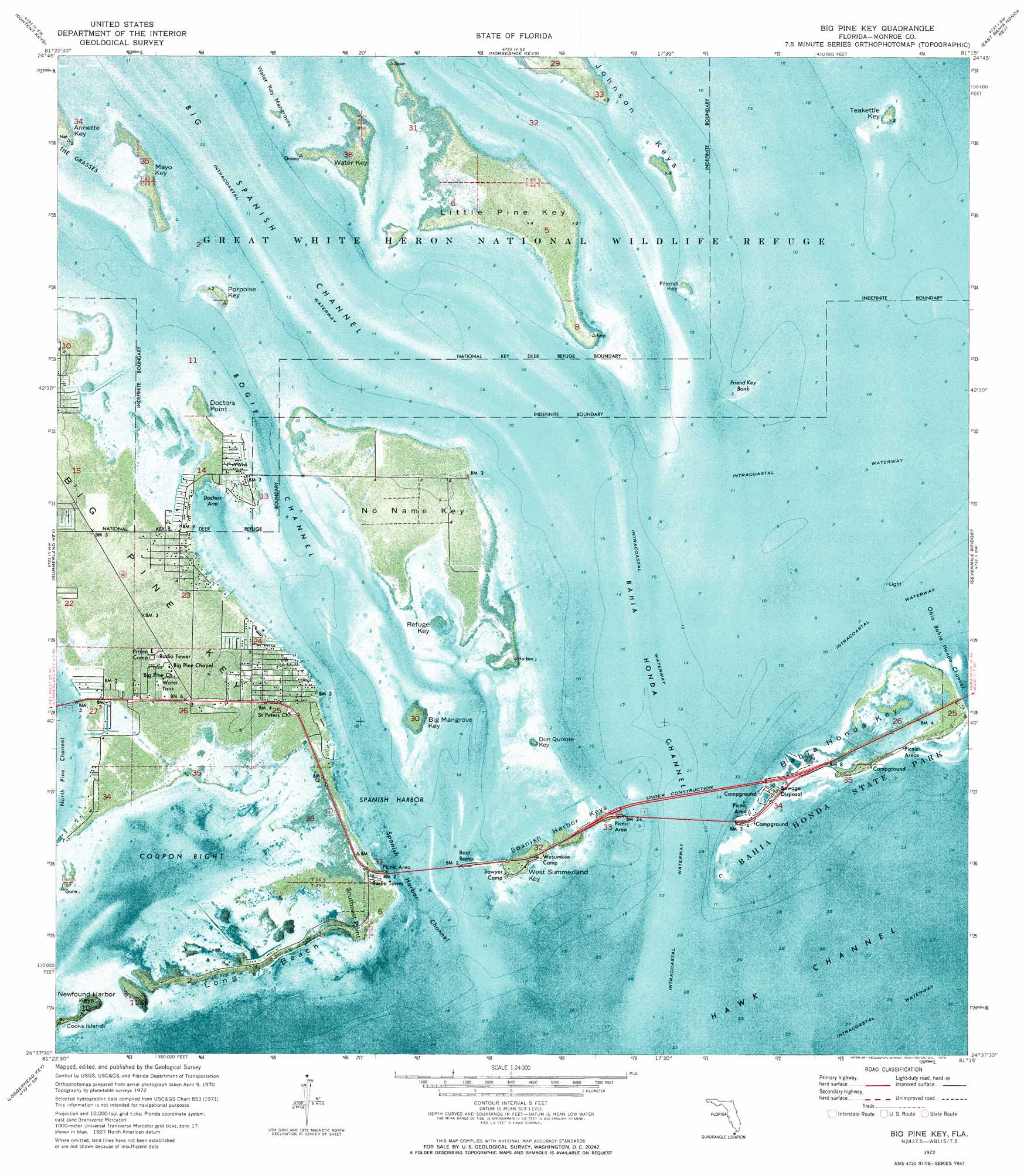
USGS Topo Quad 24081f3 - 1:24,000 scale
| Topo Map Name: | Big Pine Key |
| USGS Topo Quad ID: | 24081f3 |
| Print Size: | ca. 21 1/4" wide x 27" high |
| Southeast Coordinates: | 24.625° N latitude / 81.25° W longitude |
| Map Center Coordinates: | 24.6875° N latitude / 81.3125° W longitude |
| U.S. State: | FL |
| Filename: | P24081F3.jpg |
| Download Map JPG Image: | Big Pine Key topo map 1:24,000 scale |
| Map Type: | Orthophoto |
| Topo Series: | 7.5´ |
| Map Scale: | 1:24,000 |
| Source of Map Images: | United States Geological Survey (USGS) |
| Alternate Map Versions: |
Big Pine Key FL 1972, updated 1973 Download PDF Buy paper map Big Pine Key FL 2012 Download PDF Buy paper map Big Pine Key FL 2015 Download PDF Buy paper map |
1:24,000 Topo Quads surrounding Big Pine Key
East Bahia Honda Key Ne |
||||
Sawyer Key |
Content Keys |
Horseshoe Keys |
East Bahia Honda Key |
Bamboo Key |
Sugarloaf Key |
Summerland Key |
Big Pine Key |
Sevenmile Bridge |
Marathon |
Saddlebunch Keys |
Key Lois |
> Back to 24081e1 at 1:100,000 scale
> Back to 24080a1 at 1:250,000 scale
> Back to U.S. Topo Maps home
Big Pine Key topo map: Gazetteer
Big Pine Key: Bars
Friend Key Bank elevation 0m 0′Big Pine Key: Bays
Coupon Bight elevation 0m 0′Doctors Arm elevation 0m 0′
Pine Key Bight elevation 0m 0′
Spanish Harbor elevation 0m 0′
Big Pine Key: Beaches
Long Beach elevation 0m 0′Big Pine Key: Capes
Doctors Point elevation 0m 0′Southeast Point elevation 0m 0′
Big Pine Key: Channels
Bahia Honda Channel elevation 0m 0′Bogie Channel elevation 0m 0′
North Pine Channel elevation 0m 0′
Ohio Bahia Honda Channel elevation 0m 0′
Spanish Harbor Channel elevation 0m 0′
Big Pine Key: Islands
Bahia Honda Key elevation 0m 0′Big Mangrove Key elevation 0m 0′
Big Pine Key elevation 0m 0′
Cook Island elevation 0m 0′
Don Quixote Key elevation 0m 0′
Friend Key elevation 0m 0′
Little Pine Key elevation 0m 0′
Mayo Key elevation 0m 0′
No Name Key elevation 1m 3′
Porpoise Key elevation 0m 0′
Refuge Key elevation 0m 0′
Spanish Harbor Keys elevation 1m 3′
Teakettle Key elevation 0m 0′
Water Key elevation 0m 0′
Water Key Mangroves elevation 0m 0′
West Summerland Key elevation 1m 3′
Big Pine Key: Parks
Bahia Honda State Park elevation 0m 0′Coupon Bight Aquatic Preserve elevation 0m 0′
Big Pine Key: Populated Places
Big Pine elevation 1m 3′Big Pine Key elevation 1m 3′
Deans Trailer Park elevation 0m 0′
Howards Haven Mobile Home Park elevation 0m 0′
Big Pine Key: Post Offices
Big Pine Key Post Office elevation 1m 3′Big Pine Key digital topo map on disk
Buy this Big Pine Key topo map showing relief, roads, GPS coordinates and other geographical features, as a high-resolution digital map file on DVD: