Horseshoe Keys Topo Map Florida
To zoom in, hover over the map of Horseshoe Keys
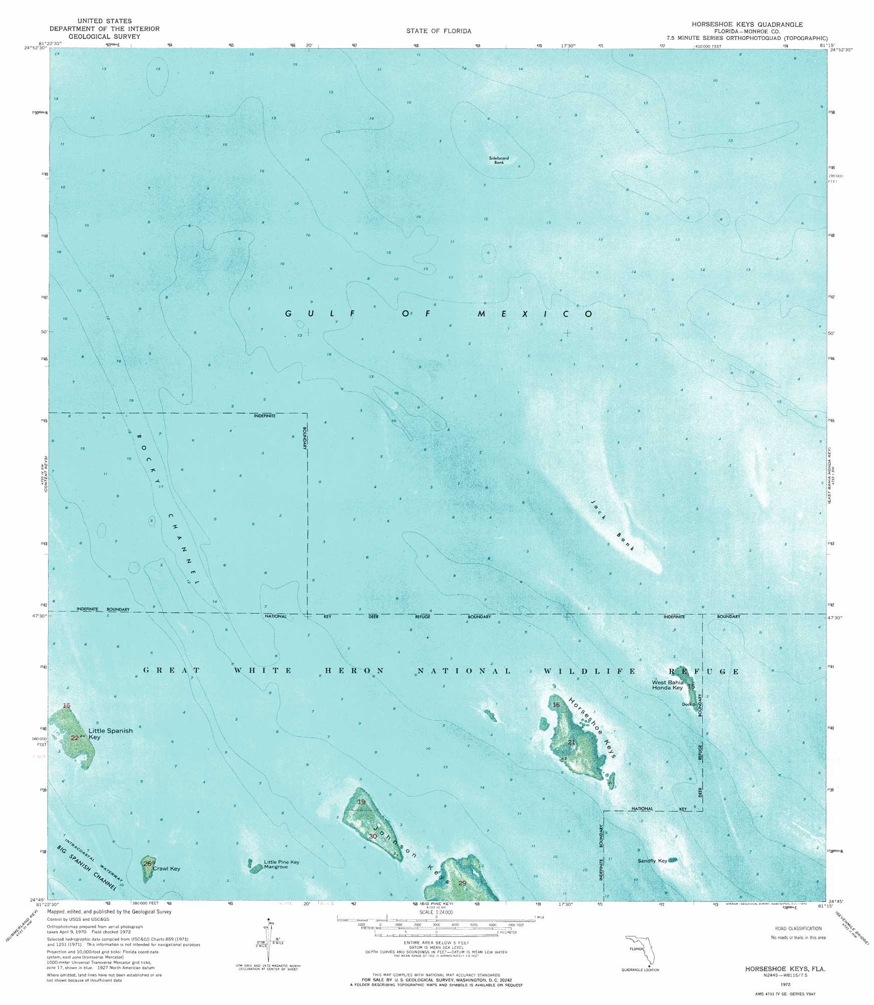
USGS Topo Quad 24081g3 - 1:24,000 scale
| Topo Map Name: | Horseshoe Keys |
| USGS Topo Quad ID: | 24081g3 |
| Print Size: | ca. 21 1/4" wide x 27" high |
| Southeast Coordinates: | 24.75° N latitude / 81.25° W longitude |
| Map Center Coordinates: | 24.8125° N latitude / 81.3125° W longitude |
| U.S. State: | FL |
| Filename: | P24081G3.jpg |
| Download Map JPG Image: | Horseshoe Keys topo map 1:24,000 scale |
| Map Type: | Orthophoto |
| Topo Series: | 7.5´ |
| Map Scale: | 1:24,000 |
| Source of Map Images: | United States Geological Survey (USGS) |
| Alternate Map Versions: |
Horseshoe Keys FL 1972, updated 1973 Download PDF Buy paper map Horseshoe Keys FL 1972, updated 1973 Download PDF Buy paper map Horseshoe Keys FL 2012 Download PDF Buy paper map Horseshoe Keys FL 2015 Download PDF Buy paper map |
1:24,000 Topo Quads surrounding Horseshoe Keys
Sandy Key |
||||
East Bahia Honda Key Ne |
||||
Sawyer Key |
Content Keys |
Horseshoe Keys |
East Bahia Honda Key |
Bamboo Key |
Sugarloaf Key |
Summerland Key |
Big Pine Key |
Sevenmile Bridge |
Marathon |
Saddlebunch Keys |
Key Lois |
> Back to 24081e1 at 1:100,000 scale
> Back to 24080a1 at 1:250,000 scale
> Back to U.S. Topo Maps home
Horseshoe Keys topo map: Gazetteer
Horseshoe Keys: Bars
Bullfrog Banks elevation 0m 0′Jack Bank elevation 0m 0′
Sideboard Bank elevation 0m 0′
Sunken Coral Heads elevation 0m 0′
Horseshoe Keys: Channels
Big Spanish Channel elevation 0m 0′Rocky Channel elevation 0m 0′
Horseshoe Keys: Islands
Crawl Key elevation 0m 0′Horseshoe Keys elevation 0m 0′
Johnson Keys elevation 0m 0′
Little Pine Key Mangrove elevation 0m 0′
Little Spanish Key elevation 0m 0′
Sandfly Key elevation 0m 0′
West Bahia Honda Key elevation 0m 0′
Horseshoe Keys digital topo map on disk
Buy this Horseshoe Keys topo map showing relief, roads, GPS coordinates and other geographical features, as a high-resolution digital map file on DVD: